more stats
1,722 ft
Distance
-196 ft
Descent
00:03:26
Avg time
-197 ft
Altitude change
958 ft
Altitude min
1,155 ft
Altitude max
1,155 ft
Altitude start
958 ft
Altitude end
-11.4%
Grade
-36%
Grade max
-4.1%
Grade min
1,722 ft
Distance down
00:03:26
Avg time

Discesa Freeride Details

  • Activities
    • Mountain Bike
    • Hike
    • Trail Running
  • Riding Area
    Vertemate Con Minoprio
    Vertemate con Minoprio
  • Difficulty Rating
  • Local Popularity
    100 in Mountain Biking [+]
    • 5 in Trail Running
    • 100 in Hiking
  • Global Ranking
    #40343 in Mountain Biking [+]
    • #139902 in Trail Running
    • #5107 in Hiking
  • Trail Type
    Singletrack
  • Bike Type
    DH, AM, XC
  • Direction
    Downhill Primary
    Popular Direction Shown
  • Physical Rating
    Easy
  • Dogs Allowed
    Yes
  • TTFs on Trail
    Drop, Jump, Roller Coaster

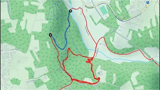
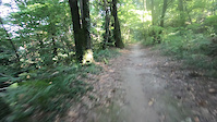
Discesa molto flow in stile bike park con curve in appoggio ben mantenute e drop/rampe di vario livello e altezza. Fondo compatto e pulito. La discesa è in stile enduro/freeride, ma poichè è sempre presente la chicken line si può intepretare anche con bici da downcountry o front XC.

Recent Activity on Trail

Past Week
  • 2 rides
  • 13 miles average
6 Months
  • 107 rides
  • 15 miles avg distance
All
  • 457 rides
  • Last: Jun 18, 2026
c1c2c3c4
January
February
March
April
May
June
July
August
September
October
November
December
Status:
on Jun 7, 2026
Variable
Avg: 4.3 (7 votes)
Your vote: 0

view (3,881)
close
3D
Trail Conditions
  • Unknown
  • Snow Groomed
  • Snow Packed
  • Snow Covered
  • Snow Cover Partial
  • Freeze/thaw Cycle
  • Icy
  • Prevalent Mud
  • Wet
  • Variable
  • Ideal
  • Dry
  • Very Dry
Trail Flow (Ridden Direction)
Trailforks scans users ridelogs to determine the most popular direction each trail is ridden. A good flowing trail network will have most trails flowing in a single direction according to their intension.
The colour categories are based on what percentage of riders are riding a trail in its intended direction.
  • > 96%
  • > 90%
  • > 80%
  • > 70%
  • > 50%
  • < 50%
  • bi-directional trail
  • no data
Trail Last Ridden
Trailforks scans ridelogs to determine the last time a trail was ridden.
  • < 2 days
  • < 1 week
  • < 2 weeks
  • < 1 month
  • < 6 months
  • > 6 months
Trail Ridden Direction
The intended direction a trail should be ridden.
  • Downhill Only
  • Downhill Primary
  • Both Directions
  • Uphill Primary
  • Uphill Only
  • One Direction
Contribute Details
Colors indicate trail is missing specified detail.
  • Description
  • Photos
  • Description & Photos
  • Videos
Trail Popularity ?
Trailforks scans ridelogs to determine which trails are ridden the most in the last 9 months. Trails are compared with nearby trails in the same city region with a possible 25 colour shades. Think of this as a heatmap, more rides = more kinetic energy = warmer colors.
  • most popular
  • popular
  • less popular
  • not popular
ATV/ORV/OHV Filter
Max Vehicle Width
inches
US Cell Coverage
Legend
cell carrier legend

Radar Time
Activity Recordings
Trailforks uses anonymized public activity data. ?
Activity Recordings
Trailforks uses anonymized public activity data. ?
Personal Heatmap
Activity Types
all / none
Options
2
Date range month
Winter Trails
Warning A routing network for winter maps does not exist. Selecting trails using the winter trails layer has been disabled.
Missing Trails
Most Popular
Least Popular
Trails are colored based on popularity. The more popular a trail is, the more red. Less popular trails trend towards green.
Jump Magnitude Heatmap
Heatmap of where riders jump on trails. Zoom in to see individual jumps, click circles to view jump details.
BC Backroad Status

Service Road Atlas is a free to use, community-driven service for viewing and creating reports on the numerous back-country service roads around B.C. and Alberta.

map legend
Slope Aspect
Direction the slope faces
Flat N NE E SE S SW W NW
Trails Deemphasized
Trails are shown in grey.
disable
Only show trails with no bike usage.
Enable
Suggested Layers
Based on selected activity type

    Save the current map location and zoom level as your default home location whenever this page is loaded.

    Save
        Directions to discesa-freeride trailhead (45.735470, 9.077190)

        Photos

        7 more »
        55 |
        Jan 29, 2024 @ 5:09am
        Jan 29, 2024
        35 |
        Sep 15, 2024 @ 9:24am
        Sep 15, 2024
        34 |
        Sep 15, 2024 @ 9:23am
        Sep 15, 2024
        39 |
        Sep 15, 2024 @ 9:23am
        Sep 15, 2024

        Videos

        2 more »
        202205  -  MTB   Vertemate Discesa Freeride
        2:48 | 290 | Dec 8, 2022 , Vertemate con Minoprio
        3:28 | 80 | Jul 24, 2024 , Vertemate con Minoprio

        2 Reviews & Comments


        We hope you've been enjoying Trailforks!

        Create a FREE account to view trail comments and much more.

        • By decos1981 & contributors
        • #113448 - 1,687 views

        Frequently Asked Questions About Discesa Freeride

        Where is Discesa Freeride located?
        Discesa Freeride is located in Vertemate Con Minoprio, Vertemate con Minoprio, Italy. It is part of the Vertemate Con Minoprio trail network. The trailhead is located at coordinates 45.73547, 9.07719.
        How hard is Discesa Freeride?
        Discesa Freeride is rated as Blue difficulty. The physical rating is Easy. The average grade is 11.4%.
        What is the elevation gain for Discesa Freeride?
        The trail has 196 ft of elevation descent. The elevation ranges from 958 ft to 1,155 ft.
        Is Discesa Freeride a point to point trail?
        Discesa Freeride is not a point to point trail. The direction is Downhill Primary. The trail type is singletrack.

        Hit the Trail

        Open in App

        Get this trail on your phone instantly.
        open trail in app

        Download Trail

        Save to wishlist, Garmin & download.
        save the trail

        Find Related Routes

        Find routes and users activities that include this trail.
        find routes for this trail

        You must enter a description before submitting.