more stats
781 ft
Distance
-104 ft
Descent
00:04:13
Avg time
-105 ft
Altitude change
868 ft
Altitude min
973 ft
Altitude max
973 ft
Altitude start
869 ft
Altitude end
-13.4%
Grade
-35.6%
Grade max
-0.8%
Grade min
705 ft
Distance down
33 ft
Distance flat
00:04:13
Avg time

Doggers Details

  • Activities
    • Mountain Bike
  • Riding Area
    Coast Gravity Park
    Sechelt, British Columbia
  • Difficulty Rating
  • Local Popularity
    95 in Mountain Biking
  • Global Ranking
    #28625 in Mountain Biking
  • Trail Type
    Singletrack
  • Bike Type
    DH, AM, XC, DJ
  • Direction
    Downhill Only
    Popular Direction Shown
  • Dogs Allowed
    Yes
  • TTFs on Trail
    Jump
  • Land Owner

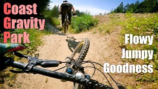
A favourite trail by many, maximum flow and fun is achieved at Dogger's with tabled jumps, hips and mage berms as seen in Ryan Howard's segment in "Arrival".

Bike Park

Traditionally Indigenous Territory

Recent Activity on Trail

Past Week
  • 2 rides
  • 11 miles average
6 Months
  • 28 rides
  • 14 miles avg distance
All
  • 410 rides
  • Last: Jun 21, 2026
c1c2c3c4
January
February
March
April
May
June
July
August
September
October
November
December
Status:
on Jul 7, 2025
Very Dry
Avg: 4.53 (41 votes)
Your vote: 0

view (6,048)
close
3D
Trail Conditions
  • Unknown
  • Snow Groomed
  • Snow Packed
  • Snow Covered
  • Snow Cover Partial
  • Freeze/thaw Cycle
  • Icy
  • Prevalent Mud
  • Wet
  • Variable
  • Ideal
  • Dry
  • Very Dry
Trail Flow (Ridden Direction)
Trailforks scans users ridelogs to determine the most popular direction each trail is ridden. A good flowing trail network will have most trails flowing in a single direction according to their intension.
The colour categories are based on what percentage of riders are riding a trail in its intended direction.
  • > 96%
  • > 90%
  • > 80%
  • > 70%
  • > 50%
  • < 50%
  • bi-directional trail
  • no data
Trail Last Ridden
Trailforks scans ridelogs to determine the last time a trail was ridden.
  • < 2 days
  • < 1 week
  • < 2 weeks
  • < 1 month
  • < 6 months
  • > 6 months
Trail Ridden Direction
The intended direction a trail should be ridden.
  • Downhill Only
  • Downhill Primary
  • Both Directions
  • Uphill Primary
  • Uphill Only
  • One Direction
Contribute Details
Colors indicate trail is missing specified detail.
  • Description
  • Photos
  • Description & Photos
  • Videos
Trail Popularity ?
Trailforks scans ridelogs to determine which trails are ridden the most in the last 9 months. Trails are compared with nearby trails in the same city region with a possible 25 colour shades. Think of this as a heatmap, more rides = more kinetic energy = warmer colors.
  • most popular
  • popular
  • less popular
  • not popular
ATV/ORV/OHV Filter
Max Vehicle Width
inches
US Cell Coverage
Legend
cell carrier legend

Radar Time
Activity Recordings
Trailforks uses anonymized public activity data. ?
Activity Recordings
Trailforks uses anonymized public activity data. ?
Personal Heatmap
Activity Types
all / none
Options
2
Date range month
Winter Trails
Warning A routing network for winter maps does not exist. Selecting trails using the winter trails layer has been disabled.
Missing Trails
Most Popular
Least Popular
Trails are colored based on popularity. The more popular a trail is, the more red. Less popular trails trend towards green.
Jump Magnitude Heatmap
Heatmap of where riders jump on trails. Zoom in to see individual jumps, click circles to view jump details.
BC Backroad Status

Service Road Atlas is a free to use, community-driven service for viewing and creating reports on the numerous back-country service roads around B.C. and Alberta.

map legend
Slope Aspect
Direction the slope faces
Flat N NE E SE S SW W NW
Trails Deemphasized
Trails are shown in grey.
disable
Only show trails with no bike usage.
Enable
Suggested Layers
Based on selected activity type

    Save the current map location and zoom level as your default home location whenever this page is loaded.

    Save
        Directions to doggers trailhead (49.501860, -123.722660)

        Photos

        16 more »
        493 |
        Jan 25, 2015 @ 10:42pm
        Jan 25, 2015
        170 |
        Mar 13, 2020 @ 5:36am
        Mar 13, 2020
        678 |
        Jan 21, 2020 @ 12:35pm
        Jan 21, 2020
        106 |
        Apr 3, 2019 @ 8:56am
        Apr 3, 2019

        Videos

        10 more »
        youtuber Red Dragon | Coast Gravity Park, BC
        2:30 | 11 | Jun 2, 2026 , Sechelt
        youtuber Exploring EVERY Trail at Coast Gravity Park - BC
        18:34 | 44 | May 16, 2026 , Sechelt
        Flowy Goodness! Coast Gravity Park | Sunshine...
        6:31 | 203 | Aug 17, 2022 , Sechelt
        youtuber Doggers - Coast Gravity
        892 | Dec 12, 2017 , Sechelt

        1 Review & Comments


        We hope you've been enjoying Trailforks!

        Create a FREE account to view trail comments and much more.

        Frequently Asked Questions About Doggers

        Where is Doggers located?
        Doggers is located in Coast Gravity Park, Sechelt, British Columbia, Canada. It is part of the Coast Gravity Park trail network. The trailhead is located at coordinates 49.50186, -123.72266.
        How hard is Doggers?
        Doggers is rated as Red difficulty. The average grade is 13.4%.
        What is the elevation gain for Doggers?
        The trail has 104 ft of elevation descent. The elevation ranges from 868 ft to 973 ft.
        Is Doggers a point to point trail?
        Yes, Doggers is a point to point trail. The direction is Downhill Only. The trail type is singletrack.

        Hit the Trail

        Open in App

        Get this trail on your phone instantly.
        open trail in app

        Download Trail

        Save to wishlist, Garmin & download.
        save the trail

        Find Related Routes

        Find routes and users activities that include this trail.
        find routes for this trail

        You must enter a description before submitting.