more stats
5.8 miles
Distance
415 ft
Climb
-4,542 ft
Descent
00:31:13
Avg time
-4,127 ft
Altitude change
460 ft
Altitude min
4,588 ft
Altitude max
4,588 ft
Altitude start
459 ft
Altitude end
-13.6%
Grade
-60%
Grade max
45.1%
Grade min
2,753 ft
Distance climb
5 miles
Distance down
157 ft
Distance flat
00:31:13
Avg time

Dome Trail Details

  • Activities
    • Mountain Bike
    • Hike
    • Trail Running
    • Snowshoe
    • Backcountry Ski
  • Riding Area
    Chugach State Park
    Anchorage, Alaska
  • Difficulty Rating
  • Local Popularity
    5 in Mountain Biking [+]
    • 5 in Trail Running
    • 35 in Hiking
    • 5 in Snowshoeing
    • 5 in Backcountry Skiing
  • Global Ranking
    #16065 in Mountain Biking [+]
    • #41898 in Trail Running
    • #3884 in Hiking
  • Trail Type
    Singletrack
  • Bike Type
    DH, AM, XC
  • Direction
    Both Directions
  • Climb Difficulty
    Black Diamond
  • Physical Rating
    Hard
  • Season
    MAY - OCT
  • Dogs Allowed
    Yes

RESTRICTED: Requires check-in on JBER iSportsman.

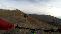
This is one of the best Anchorage area singletrack trails for riders that like a climbing challenge and can handle higher speeds with limited sight-lines and technical terrain. There are VERY steep sections, that even the best climbers will have to hike their bikes up, but the payoff is well worth the pain.

To get to the trailhead, park at the North Bivouac trailhead on the left when heading up Campbell Airstrip Road. Follow the doubletrack trail for a couple of miles, passing the stout metal fence next to Stuckagain Heights Trail. **From this point, you need to be signed in to the JBER iSportsman website.** Once past this gate, you'll descend a little more doubletrack and cross a wooden/metal bridge. Ride the gravel road for about a half mile(roughly), keeping an eye to the right for the unmarked clearing with a trail leading into the woods. This is the start of The Dome Trail.

Once on the trail, there is a steady climb with punchy steep sections until you get to a T intersection. Take a left at this T, the climb continues, with several steeper sections and more technical terrain. Just below the overlook, there is a STEEP, loose rocky climb. Once on the overlook, you can turn around the head down or keep climbing up and gain the ridgeline to the west (obvious trail) and extend this ride longer.

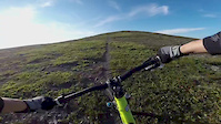
Enjoy the ride down At the T intersection, make a right and keep on smiling.

Note: There is an alternate route from Basher Road to get to the T intersection, but it eliminates the second half of the trail, which is the very fun flowy section.
show less text


Map Data
Terms of Use

Access Info Restricted Access

Getting to this trail requires the JBER iSportsman Pass (available here: jber.isportsman.net/). It is not suggested to ride this trail during peak times, as there are many hikers and you WILL be traveling fast on the descent.

Disclaimer

This is a multi-use trail. Please be courteous to the other trail users.

Local Trail Association
Traditionally Indigenous Territory

Recent Activity on Trail

Past Week
  • 0 rides
  •  
6 Months
  • 0 rides
  •  
All
  • 8 rides
  • Last: Nov 24, 2022
c1c2c3c4
January
February
March
April
May
June
July
August
September
October
November
December
update trails status or condition

Dome Trail Trail Reports

statusdatedescription
Aug 31, 2025 @ 6:13pm
Aug 31, 2025
A few of the lower sections almost totally covered by grass and weeds. But overall good trail conditions. Don't let some reports fool ya. This is...
Jul 12, 2024 @ 4:01pm
Jul 12, 2024
A little bushy but not too bad for July.
May 29, 2024 @ 5:49pm
May 29, 2024
Running great, on rainy days a few mud spots on upoer trail.
Nov 11, 2023 @ 6:06pm
Nov 11, 2023
First snow, status report needed
Jul 1, 2023 @ 6:28pm
Jul 1, 2023
Excellent condition. You’ll want sleeves, and full leather gloves. I took a few devils club to the back of my hands and it’s going to more...
more »
Status:
on Aug 31, 2025
Variable
Avg: 4.45 (5 votes)
Your vote: 0

view (184)
close
3D
Trail Conditions
  • Unknown
  • Snow Groomed
  • Snow Packed
  • Snow Covered
  • Snow Cover Partial
  • Freeze/thaw Cycle
  • Icy
  • Prevalent Mud
  • Wet
  • Variable
  • Ideal
  • Dry
  • Very Dry
Trail Flow (Ridden Direction)
Trailforks scans users ridelogs to determine the most popular direction each trail is ridden. A good flowing trail network will have most trails flowing in a single direction according to their intension.
The colour categories are based on what percentage of riders are riding a trail in its intended direction.
  • > 96%
  • > 90%
  • > 80%
  • > 70%
  • > 50%
  • < 50%
  • bi-directional trail
  • no data
Trail Last Ridden
Trailforks scans ridelogs to determine the last time a trail was ridden.
  • < 2 days
  • < 1 week
  • < 2 weeks
  • < 1 month
  • < 6 months
  • > 6 months
Trail Ridden Direction
The intended direction a trail should be ridden.
  • Downhill Only
  • Downhill Primary
  • Both Directions
  • Uphill Primary
  • Uphill Only
  • One Direction
Contribute Details
Colors indicate trail is missing specified detail.
  • Description
  • Photos
  • Description & Photos
  • Videos
Trail Popularity ?
Trailforks scans ridelogs to determine which trails are ridden the most in the last 9 months. Trails are compared with nearby trails in the same city region with a possible 25 colour shades. Think of this as a heatmap, more rides = more kinetic energy = warmer colors.
  • most popular
  • popular
  • less popular
  • not popular
ATV/ORV/OHV Filter
Max Vehicle Width
inches
US Cell Coverage
Legend
cell carrier legend

Radar Time
Activity Recordings
Trailforks uses anonymized public activity data. ?
Activity Recordings
Trailforks uses anonymized public activity data. ?
Personal Heatmap
Activity Types
all / none
Options
2
Date range month
Winter Trails
Warning A routing network for winter maps does not exist. Selecting trails using the winter trails layer has been disabled.
Missing Trails
Most Popular
Least Popular
Trails are colored based on popularity. The more popular a trail is, the more red. Less popular trails trend towards green.
Jump Magnitude Heatmap
Heatmap of where riders jump on trails. Zoom in to see individual jumps, click circles to view jump details.
BC Backroad Status

Service Road Atlas is a free to use, community-driven service for viewing and creating reports on the numerous back-country service roads around B.C. and Alberta.

map legend
Slope Aspect
Direction the slope faces
Flat N NE E SE S SW W NW
Trails Deemphasized
Trails are shown in grey.
disable
Only show trails with no bike usage.
Enable
Suggested Layers
Based on selected activity type

    Save the current map location and zoom level as your default home location whenever this page is loaded.

    Save
        Directions to dome-trail trailhead (61.158350, -149.587580)

        Photos

        18 more »
        93 |
        Oct 26, 2025 @ 8:39pm
        Oct 26, 2025
        52 |
        Sep 5, 2025 @ 12:55pm
        Sep 5, 2025
        81 |
        Oct 8, 2024 @ 11:17am
        Oct 8, 2024
        193 |
        Jul 1, 2023 @ 7:03pm
        Jul 1, 2023

        Videos

        2 more »
        2:15 | 913 | Sep 26, 2016 , Anchorage
        Dome Trail Anchorage
        0:49 | 792 | May 30, 2016 , Anchorage

        6 Reviews & Comments


        We hope you've been enjoying Trailforks!

        Create a FREE account to view trail comments and much more.

        Frequently Asked Questions About Dome Trail

        Where is Dome Trail located?
        Dome Trail is located in Chugach State Park, Anchorage, Alaska, United States. It is part of the Chugach State Park trail network. The trailhead is located at coordinates 61.15835, -149.58758.
        How hard is Dome Trail?
        Dome Trail is rated as Black Diamond difficulty. The physical rating is Hard. The average grade is 13.6%. The climb difficulty is rated Black Diamond.
        What is the elevation gain for Dome Trail?
        Dome Trail has 415 ft of elevation gain. The trail has 4,542 ft of elevation descent. The elevation ranges from 460 ft to 4,588 ft.
        Is Dome Trail a point to point trail?
        Dome Trail is not a point to point trail. The direction is Both Directions. The trail type is singletrack.

        Hit the Trail

        Open in App

        Get this trail on your phone instantly.
        open trail in app

        Download Trail

        Save to wishlist, Garmin & download.
        save the trail

        Find Related Routes

        Find routes and users activities that include this trail.
        find routes for this trail

        You must enter a description before submitting.