more stats
2,083 ft
Distance
-486 ft
Descent
00:10:15
Avg time
-486 ft
Altitude change
463 ft
Altitude min
948 ft
Altitude max
948 ft
Altitude start
463 ft
Altitude end
-23.3%
Grade
-57.9%
Grade max
-7.1%
Grade min
2,083 ft
Distance down
00:10:15
Avg time

Double Happy Details

  • Activities
    • Mountain Bike
    • E-Bike
  • Riding Area
  • Difficulty Rating
  • Voted Difficulty
    Black Diamond (4 votes)
  • Local Popularity
    75 in Mountain Biking [+]
    • 75 in E-Biking
  • Global Ranking
    #11244 in Mountain Biking [+]
    • #33157 in E-Biking
  • Trail Type
    Singletrack
  • Bike Type
    DH, AM
  • Direction
    Downhill Only
    Popular Direction Shown
  • Trail Visibility
    Always easy to follow
  • eBike Allowed
    Yes up to Class 1
  • Year Opened
    2023

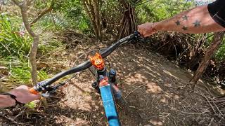
A tight tech trail hand built by WTP grade 5 dig crew.

Entry is at the grade 5 hub between Dig This and Pavlova and exits on to Mohaka Meander.

These trails are easily damaged when ridden in the wet so please stay off them after heavy rain until they are dry.

Local Trail Association

Recent Activity on Trail

Past Week
  • 0 rides
  •  
6 Months
  • 21 rides
  • 12 miles avg distance
All
  • 87 rides
  • Last: May 30, 2026
c1c2c3c4
January
February
March
April
May
June
July
August
September
October
November
December
update trails status or condition

Double Happy Trail Reports

statusdatedescription
Dec 15, 2025 @ 10:54pm (Pacific/Auckland)
Dec 15, 2025
Ruts developing early in trail where there used to be none. It’s very dry right now but must have been ridden recently in the wet. Stay off it...
Feb 15, 2024 @ 7:12pm
Feb 15, 2024
Running mint
Nov 4, 2023 @ 6:17pm
Nov 4, 2023
Extremely difficult more like a g6 or pro line. Very steep sections not for the faint hearted
more »
Status:
on Dec 15, 2025
Very Dry
Avg: 4.08 (6 votes)
Your vote: 0

view (556)
close
3D
Trail Conditions
  • Unknown
  • Snow Groomed
  • Snow Packed
  • Snow Covered
  • Snow Cover Partial
  • Freeze/thaw Cycle
  • Icy
  • Prevalent Mud
  • Wet
  • Variable
  • Ideal
  • Dry
  • Very Dry
Trail Flow (Ridden Direction)
Trailforks scans users ridelogs to determine the most popular direction each trail is ridden. A good flowing trail network will have most trails flowing in a single direction according to their intension.
The colour categories are based on what percentage of riders are riding a trail in its intended direction.
  • > 96%
  • > 90%
  • > 80%
  • > 70%
  • > 50%
  • < 50%
  • bi-directional trail
  • no data
Trail Last Ridden
Trailforks scans ridelogs to determine the last time a trail was ridden.
  • < 2 days
  • < 1 week
  • < 2 weeks
  • < 1 month
  • < 6 months
  • > 6 months
Trail Ridden Direction
The intended direction a trail should be ridden.
  • Downhill Only
  • Downhill Primary
  • Both Directions
  • Uphill Primary
  • Uphill Only
  • One Direction
Contribute Details
Colors indicate trail is missing specified detail.
  • Description
  • Photos
  • Description & Photos
  • Videos
Trail Popularity ?
Trailforks scans ridelogs to determine which trails are ridden the most in the last 9 months. Trails are compared with nearby trails in the same city region with a possible 25 colour shades. Think of this as a heatmap, more rides = more kinetic energy = warmer colors.
  • most popular
  • popular
  • less popular
  • not popular
ATV/ORV/OHV Filter
Max Vehicle Width
inches
US Cell Coverage
Legend
cell carrier legend

Radar Time
Activity Recordings
Trailforks uses anonymized public activity data. ?
Activity Recordings
Trailforks uses anonymized public activity data. ?
Personal Heatmap
Activity Types
all / none
Options
2
Date range month
Winter Trails
Warning A routing network for winter maps does not exist. Selecting trails using the winter trails layer has been disabled.
Missing Trails
Most Popular
Least Popular
Trails are colored based on popularity. The more popular a trail is, the more red. Less popular trails trend towards green.
Jump Magnitude Heatmap
Heatmap of where riders jump on trails. Zoom in to see individual jumps, click circles to view jump details.
BC Backroad Status

Service Road Atlas is a free to use, community-driven service for viewing and creating reports on the numerous back-country service roads around B.C. and Alberta.

map legend
Slope Aspect
Direction the slope faces
Flat N NE E SE S SW W NW
Trails Deemphasized
Trails are shown in grey.
disable
Only show trails with no bike usage.
Enable
Suggested Layers
Based on selected activity type

    Save the current map location and zoom level as your default home location whenever this page is loaded.

    Save
        Directions to double-happy trailhead (-41.235470, 174.933850)

        Photos

        No photos have been added for Double Happy yet, add a photo.

        Videos

        2 more »
        youtuber Double Happy @ Wainuiomata Trail Park
        4:16 | 430 | Oct 30, 2023 , Lower Hutt
        Is this the best grade 5 MTB trail in...
        3:23 | 166 | Jan 2, 2025 , Lower Hutt
        youtuber Double Happy @ Wainuiomata Trail Park
        4:16 | 335 | Nov 13, 2023 , Lower Hutt

        Routes with this trail

        21 miles 5,052 ft 28 Loop Race
        egfhwb UILYGFHWIue4rghilwue4rghyilweu4ghyrlwIJ4GYI

        7 Reviews & Comments


        We hope you've been enjoying Trailforks!

        Create a FREE account to view trail comments and much more.

        • By blackohTF Pro & contributors
        • #699054 - 1,044 views

        Frequently Asked Questions About Double Happy

        Where is Double Happy located?
        Double Happy is located in Wainuiomata Trail Park (WTP), Lower Hutt, New Zealand. It is part of the Wainuiomata Trail Park (WTP) trail network. The trailhead is located at coordinates -41.23547, 174.93385.
        How hard is Double Happy?
        Double Happy is rated as Black Diamond difficulty. The average grade is 23.3%.
        What is the elevation gain for Double Happy?
        The trail has 148 m of elevation descent. The elevation ranges from 141 m to 289 m.
        Is Double Happy a point to point trail?
        Yes, Double Happy is a point to point trail. The direction is Downhill Only. The trail type is singletrack.

        Hit the Trail

        Open in App

        Get this trail on your phone instantly.
        open trail in app

        Download Trail

        Save to wishlist, Garmin & download.
        save the trail

        Find Related Routes

        Find routes and users activities that include this trail.
        find routes for this trail

        You must enter a description before submitting.