more stats
2.0 miles
Distance
-1,342 ft
Descent
00:16:07
Avg time
-1,342 ft
Altitude change
466 ft
Altitude min
1,808 ft
Altitude max
1,808 ft
Altitude start
466 ft
Altitude end
-12.8%
Grade
-49.8%
Grade max
0.4%
Grade min
2 miles
Distance down
348 ft
Distance flat
00:16:07
Avg time

Down 'N Rowdy Details

  • Activities
    • Mountain Bike
    • E-Bike
    • Hike
    • Trail Running
  • Riding Area
    North Slope Trails
    Olympia, Washington
  • AKA
    Do Not Ride
  • Difficulty Rating
  • Voted Difficulty
    Black Diamond (2 votes)
  • Local Popularity
    95 in Mountain Biking [+]
    • 100 in E-Biking
    • 5 in Trail Running
    • 65 in Hiking
  • Global Ranking
    #22125 in Mountain Biking [+]
    • #2065 in E-Biking
    • #127751 in Trail Running
    • #120930 in Hiking
  • Trail Type
    Singletrack
  • Bike Type
    DH, AM
  • Direction
    Downhill Primary
    Popular Direction Shown
  • Physical Rating
    Moderate
  • Dogs Allowed
    Yes
  • eBike Allowed
    Yes up to Class 1
  • Land Owner
    WA State DNR

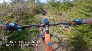
Down and Rowdy (DNR) is a long, technical freeride/enduro trail and part of the new North Slope Trails system of one-way, purpose-built mountain bike trails. Narrow all the way and steep in spots, this killer trail will challenge riders of all abilities. Access via the ORV Tie climb or by climbing or shuttling A-Line.

Local Trail Association
Traditionally Indigenous Territory

Recent Activity on Trail

Past Week
  • 0 rides
  •  
6 Months
  • 85 rides
  • 16 miles avg distance
All
  • 475 rides
  • Last: Jun 6, 2026
c1c2c3c4
January
February
March
April
May
June
July
August
September
October
November
December
update trails status or condition

Down 'N Rowdy Trail Reports

statusdatedescription
Jun 11, 2026 @ 5:43pm (America/Los_Angeles)
Jun 11, 2026
Not approved
Closed likely due to logging operations.
Jun 11, 2026 @ 5:43pm (America/Los_Angeles)
Jun 11, 2026
Not approved
Closed likely due to logging operations
Jun 10, 2026 @ 8:24am (America/Los_Angeles)
Jun 10, 2026
Not approved
Fence at trailhead with Closed sign.
Apr 5, 2026 @ 10:31pm (America/Los_Angeles)
Apr 5, 2026
Mar 4, 2026 @ 1:41pm (America/Los_Angeles)
Mar 4, 2026
Overall wet, but still riding very well 3/4/26
more »
Status:
on Apr 5, 2026
Ideal
Avg: 4.39 (35 votes)
Your vote: 0

view (3,938)
close
3D
Trail Conditions
  • Unknown
  • Snow Groomed
  • Snow Packed
  • Snow Covered
  • Snow Cover Partial
  • Freeze/thaw Cycle
  • Icy
  • Prevalent Mud
  • Wet
  • Variable
  • Ideal
  • Dry
  • Very Dry
Trail Flow (Ridden Direction)
Trailforks scans users ridelogs to determine the most popular direction each trail is ridden. A good flowing trail network will have most trails flowing in a single direction according to their intension.
The colour categories are based on what percentage of riders are riding a trail in its intended direction.
  • > 96%
  • > 90%
  • > 80%
  • > 70%
  • > 50%
  • < 50%
  • bi-directional trail
  • no data
Trail Last Ridden
Trailforks scans ridelogs to determine the last time a trail was ridden.
  • < 2 days
  • < 1 week
  • < 2 weeks
  • < 1 month
  • < 6 months
  • > 6 months
Trail Ridden Direction
The intended direction a trail should be ridden.
  • Downhill Only
  • Downhill Primary
  • Both Directions
  • Uphill Primary
  • Uphill Only
  • One Direction
Contribute Details
Colors indicate trail is missing specified detail.
  • Description
  • Photos
  • Description & Photos
  • Videos
Trail Popularity ?
Trailforks scans ridelogs to determine which trails are ridden the most in the last 9 months. Trails are compared with nearby trails in the same city region with a possible 25 colour shades. Think of this as a heatmap, more rides = more kinetic energy = warmer colors.
  • most popular
  • popular
  • less popular
  • not popular
ATV/ORV/OHV Filter
Max Vehicle Width
inches
US Cell Coverage
Legend
cell carrier legend

Radar Time
Activity Recordings
Trailforks uses anonymized public activity data. ?
Activity Recordings
Trailforks uses anonymized public activity data. ?
Personal Heatmap
Activity Types
all / none
Options
2
Date range month
Winter Trails
Warning A routing network for winter maps does not exist. Selecting trails using the winter trails layer has been disabled.
Missing Trails
Most Popular
Least Popular
Trails are colored based on popularity. The more popular a trail is, the more red. Less popular trails trend towards green.
Jump Magnitude Heatmap
Heatmap of where riders jump on trails. Zoom in to see individual jumps, click circles to view jump details.
BC Backroad Status

Service Road Atlas is a free to use, community-driven service for viewing and creating reports on the numerous back-country service roads around B.C. and Alberta.

map legend
Slope Aspect
Direction the slope faces
Flat N NE E SE S SW W NW
Trails Deemphasized
Trails are shown in grey.
disable
Only show trails with no bike usage.
Enable
Suggested Layers
Based on selected activity type

    Save the current map location and zoom level as your default home location whenever this page is loaded.

    Save
        Directions to down--n-rowdy-128040 trailhead (47.037760, -123.171230)

        Photos

        47 more »
        501 |
        Apr 26, 2019 @ 10:35am
        Apr 26, 2019
        509 |
        Apr 26, 2019 @ 10:34am
        Apr 26, 2019
        184 |
        Jul 6, 2021 @ 9:54pm
        Jul 6, 2021
        173 |
        Aug 19, 2020 @ 10:47pm
        Aug 19, 2020

        Videos

        12 more »
        youtuber Down 'N Rowdy, North Slope || LoFi Ride
        8:39 | 585 | Dec 30, 2023 , Olympia
        youtuber Down N Rowdy - North Slope Trails - Capitol...
        11:30 | 377 | Nov 13, 2022 , Olympia
        youtuber Down 'N Rowdy / Olympia, CA / MTB
        7:51 | 130 | Jul 1, 2025 , Olympia
        Down and Rowdy Trail -- North Slope Olympic...
        6:09 | 91 | May 5, 2025 , Olympia

        Routes with this trail

        5.0 16 miles 4,932 ft 12 Race
        17 miles 3,571 ft 13
        A sport course XC idea, avoids any expert downhill trails. Plenty of fun moto trails and some good...
        5.0 9 miles 2,636 ft 15
        Loop to hit two DH trails on the North Slope

        10 Reviews & Comments


        We hope you've been enjoying Trailforks!

        Create a FREE account to view trail comments and much more.

        • By racecascadiaTF Pro FOCF & contributors
        • #128040 - 12,669 views

        Frequently Asked Questions About Down 'N Rowdy

        Where is Down 'N Rowdy located?
        Down 'N Rowdy is located in North Slope Trails, Olympia, Washington, United States. It is part of the North Slope Trails trail network. The trailhead is located at coordinates 47.03776, -123.17123.
        How hard is Down 'N Rowdy?
        Down 'N Rowdy is rated as Black Diamond difficulty. The physical rating is Moderate. The average grade is 12.8%.
        What is the elevation gain for Down 'N Rowdy?
        The trail has 1,342 ft of elevation descent. The elevation ranges from 466 ft to 1,808 ft.
        Is Down 'N Rowdy a point to point trail?
        Down 'N Rowdy is not a point to point trail. The direction is Downhill Primary. The trail type is singletrack.

        Hit the Trail

        Open in App

        Get this trail on your phone instantly.
        open trail in app

        Download Trail

        Save to wishlist, Garmin & download.
        save the trail

        Find Related Routes

        Find routes and users activities that include this trail.
        find routes for this trail

        You must enter a description before submitting.