more stats
2,595 ft
Distance
35 ft
Climb
-244 ft
Descent
00:03:53
Avg time
-209 ft
Altitude change
1,484 ft
Altitude min
1,693 ft
Altitude max
1,693 ft
Altitude start
1,483 ft
Altitude end
-8.1%
Grade
-48.8%
Grade max
14.6%
Grade min
515 ft
Distance climb
1,824 ft
Distance down
256 ft
Distance flat
00:03:53
Avg time

Down DJ Details

  • Activities
    • Mountain Bike
    • E-Bike
    • Winter Fat Bike
  • Riding Area
  • Difficulty Rating
  • Voted Difficulty
    Blue (2 votes)
  • Local Popularity
    65 in Mountain Biking [+]
    • 85 in E-Biking
  • Global Ranking
    #14120 in Mountain Biking [+]
    • #3464 in E-Biking
  • Trail Type
    Singletrack
  • Bike Type
    DH, AM, XC, DJ, Fat
  • Physical Rating
    Easy
  • eBike Allowed
  • TTFs on Trail
    Berm, Drop, Jump, Gap Jump
  • Year Opened
    2017
  • Land Owner
    Hancock Victorian Plantations

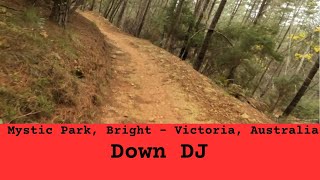
Down DJ is a wide, machine made flow trail with optional A lines on the sides. Enjoy the rollercoaster ride!
Easily accessed by the Up DJ climbing trail.

Trail Supporters

Bike Park

Local Trail Association
Traditionally Indigenous Territory

Recent Activity on Trail

Past Week
  • 0 rides
  •  
6 Months
  • 21 rides
  • 16 miles avg distance
All
  • 632 rides
  • Last: Jun 21, 2026
c1c2c3c4
January
February
March
April
May
June
July
August
September
October
November
December
update trails status or condition

Down DJ Trail Reports

statusdatedescription
Mar 12, 2026 @ 11:30am (Australia/Melbourne)
Mar 11, 2026
Due to postponement of the Harvest the trail is now OPEN
Jan 27, 2026 @ 10:43am (Australia/Melbourne)
Jan 26, 2026
Closed due to harvest. Visit our website for more information: https://www.elevationmystic.com/media/harvesting-oct25/
Dec 24, 2025 @ 9:41am (Australia/Melbourne)
Dec 23, 2025
Trail is temporarily open for Dec/Jan season
Oct 6, 2025 @ 11:38am (Australia/Melbourne)
Oct 5, 2025
Permanently closed due to harvesting.
Oct 6, 2025 @ 11:37am (Australia/Melbourne)
Oct 5, 2025
Permanently closed due to harvesting.
more »
Status:
on Mar 12, 2026
Ideal
Avg: 4.2 (19 votes)
Your vote: 0

view (6,588)
close
3D
Trail Conditions
  • Unknown
  • Snow Groomed
  • Snow Packed
  • Snow Covered
  • Snow Cover Partial
  • Freeze/thaw Cycle
  • Icy
  • Prevalent Mud
  • Wet
  • Variable
  • Ideal
  • Dry
  • Very Dry
Trail Flow (Ridden Direction)
Trailforks scans users ridelogs to determine the most popular direction each trail is ridden. A good flowing trail network will have most trails flowing in a single direction according to their intension.
The colour categories are based on what percentage of riders are riding a trail in its intended direction.
  • > 96%
  • > 90%
  • > 80%
  • > 70%
  • > 50%
  • < 50%
  • bi-directional trail
  • no data
Trail Last Ridden
Trailforks scans ridelogs to determine the last time a trail was ridden.
  • < 2 days
  • < 1 week
  • < 2 weeks
  • < 1 month
  • < 6 months
  • > 6 months
Trail Ridden Direction
The intended direction a trail should be ridden.
  • Downhill Only
  • Downhill Primary
  • Both Directions
  • Uphill Primary
  • Uphill Only
  • One Direction
Contribute Details
Colors indicate trail is missing specified detail.
  • Description
  • Photos
  • Description & Photos
  • Videos
Trail Popularity ?
Trailforks scans ridelogs to determine which trails are ridden the most in the last 9 months. Trails are compared with nearby trails in the same city region with a possible 25 colour shades. Think of this as a heatmap, more rides = more kinetic energy = warmer colors.
  • most popular
  • popular
  • less popular
  • not popular
ATV/ORV/OHV Filter
Max Vehicle Width
inches
US Cell Coverage
Legend
cell carrier legend

Radar Time
Activity Recordings
Trailforks uses anonymized public activity data. ?
Activity Recordings
Trailforks uses anonymized public activity data. ?
Personal Heatmap
Activity Types
all / none
Options
2
Date range month
Winter Trails
Warning A routing network for winter maps does not exist. Selecting trails using the winter trails layer has been disabled.
Missing Trails
Most Popular
Least Popular
Trails are colored based on popularity. The more popular a trail is, the more red. Less popular trails trend towards green.
Jump Magnitude Heatmap
Heatmap of where riders jump on trails. Zoom in to see individual jumps, click circles to view jump details.
BC Backroad Status

Service Road Atlas is a free to use, community-driven service for viewing and creating reports on the numerous back-country service roads around B.C. and Alberta.

map legend
Slope Aspect
Direction the slope faces
Flat N NE E SE S SW W NW
Trails Deemphasized
Trails are shown in grey.
disable
Only show trails with no bike usage.
Enable
Suggested Layers
Based on selected activity type

    Save the current map location and zoom level as your default home location whenever this page is loaded.

    Save
        Directions to down-dj trailhead (-36.750390, 146.963290)

        Photos

        No photos have been added for Down DJ yet, add a photo.

        Videos

        9 more »
        youtuber Mystic Park - Down DJ
        2:15 | 82 | Sep 21, 2025 , Bright
        Down DJ | Trail of the week | Mystic Bike Park
        0:48 | 111 | Jan 22, 2025 , Bright
        RideCraft MTB Trail Preview: Down DJ | Mystic...
        3:14 | 211 | Mar 12, 2024 , Bright
        Down DJ, Mystic MTB Park, Bright
        2:08 | 2040 | Mar 4, 2019 , Bright

        Routes with this trail

        15 miles 2,958 ft 56 Out & Back Race
        THULE B24 GE (trad) 2017 - 4 stages, practice saturday 12pm-9pm, race sunday 7am-12pm

        6 Reviews & Comments


        We hope you've been enjoying Trailforks!

        Create a FREE account to view trail comments and much more.

        • By DanMillarTF Pro & contributors
        • #98552 - 7,048 views

        Frequently Asked Questions About Down DJ

        Where is Down DJ located?
        Down DJ is located in Mystic Bike Park, Bright, Australia. It is part of the Mystic Bike Park trail network. The trailhead is located at coordinates -36.75039, 146.96329.
        How hard is Down DJ?
        Down DJ is rated as Blue difficulty. The physical rating is Easy. The average grade is 8.1%.
        What is the elevation gain for Down DJ?
        Down DJ has 11 m of elevation gain. The trail has 74 m of elevation descent. The elevation ranges from 452 m to 516 m.
        How long is Down DJ?
        Down DJ is 791.0 m long. The trail type is singletrack.

        Hit the Trail

        Open in App

        Get this trail on your phone instantly.
        open trail in app

        Download Trail

        Save to wishlist, Garmin & download.
        save the trail

        Find Related Routes

        Find routes and users activities that include this trail.
        find routes for this trail

        You must enter a description before submitting.