more stats
1.4 miles
Distance
33 ft
Climb
-995 ft
Descent
00:15:34
Avg time
-962 ft
Altitude change
889 ft
Altitude min
1,853 ft
Altitude max
1,853 ft
Altitude start
891 ft
Altitude end
-13.466%
Grade
-53.167%
Grade max
13.24%
Grade min
967 ft
Distance climb
1 mile
Distance down
549 ft
Distance flat
00:15:34
Avg time

Downhill Mt Coramba Details

  • Activities
    • Mountain Bike
  • Riding Area
    Mt Coramba
    Coffs Harbour
  • AKA
    Mt Coramba DH
  • Difficulty Rating
  • Local Popularity
    30 in Mountain Biking
  • Global Ranking
    #96378 in Mountain Biking
  • Trail Type
    Singletrack
  • Bike Type
    DH, AM
  • Direction
    Downhill Only
    Popular Direction Shown
  • Physical Rating
    Extreme
  • Dogs Allowed
    Yes
  • eBike Allowed
    Yes up to Class 1
  • TTFs on Trail
    Berm, Drop, Jump, Gap Jump, Rock Garden
  • Land Owner

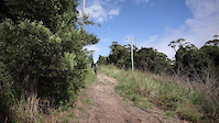
Overview: One of Australia’s most renowned and long standing downhill trails is surrounded by the beauty of the Coffs Harbour forested areas with spectacular views of the mountains and the sea.

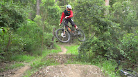
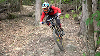
The trail has a rich history and is known for it’s amazing build quality and attention to detail. It is a pure downhill trail, managed Woolgoolga Mountain Bike Club. The exciting trail contains an abundance of features including smooth jumps, exciting drops, fun fast sections and challenging natural obstacles planned and built around the natural shapes of our beautiful forest.

Detail: The trail starts at one of two towers on top of Mt Coramba. The typical trail head starts at the lower tower with a more advanced section from the top tower. The trail is just over two kilometers long bearing east towards the sea and is entirely gravity fed. The trail contains many firm bermed sections, a lot of gap jumps, advanced drops and technical sections to be ridden only by experienced and advanced riders. Some sections have an alternate line to avoid the difficult obstacles but are still intermediate level.

The trail ends with some jumps built to thrill the rider and the people visiting to spectate in an open area designed to exhibit the exciting sport. Spectators are encouraged to come along and watch any of our events that can be found at www.facebook.com/WoolgoolgaMTB

Access to the trail is on a weathered dirt road. 4WD access is recommended and caution is advised if using a 2WD vehicle. Please be mindful of other road users.

Access Info

Contact Woolgoolga Mountain Bike Club for trail access. The trail is closed on wet days and not to be ridden.

Disclaimer

This trail is managed by Woolgoolga Mountain Bike Club

Trail Supporters
  • https://www.facebook.com/WoolgoolgaMTB
    Maintainer
Traditionally Indigenous Territory

Recent Activity on Trail

Past Week
  • 0 rides
  •  
6 Months
  • 0 rides
  •  
All
  • 5 rides
  • Last: Dec 5, 2025
c1c2c3c4
January
February
March
April
May
June
July
August
September
October
November
December
update trails status or condition

Downhill Mt Coramba Trail Reports

statusdatedescription
Sep 29, 2024 @ 8:53pm
Sep 29, 2024
Complete rework of this track has improved it vastly highly recommend, complete revival of this awesome track
Jul 15, 2023 @ 2:50am
Jul 15, 2023
Jun 29, 2023 @ 10:50pm
Jun 29, 2023
Track is clear, but some minor repairs are needed on the ramps for some features. The road up to Mt Coramba is in poor condition.
Jun 15, 2021 @ 5:03pm
Jun 15, 2021
Running sweet as...get out there and enjoy
Apr 24, 2021 @ 4:56pm
Apr 24, 2021
A few stray rocks and branches but flows well
more »
Status:
on Sep 29, 2024
Ideal
Avg: 3.9 (5 votes)
Your vote: 0

view (63)
close
3D
Trail Conditions
  • Unknown
  • Snow Groomed
  • Snow Packed
  • Snow Covered
  • Snow Cover Partial
  • Freeze/thaw Cycle
  • Icy
  • Prevalent Mud
  • Wet
  • Variable
  • Ideal
  • Dry
  • Very Dry
Trail Flow (Ridden Direction)
Trailforks scans users ridelogs to determine the most popular direction each trail is ridden. A good flowing trail network will have most trails flowing in a single direction according to their intension.
The colour categories are based on what percentage of riders are riding a trail in its intended direction.
  • > 96%
  • > 90%
  • > 80%
  • > 70%
  • > 50%
  • < 50%
  • bi-directional trail
  • no data
Trail Last Ridden
Trailforks scans ridelogs to determine the last time a trail was ridden.
  • < 2 days
  • < 1 week
  • < 2 weeks
  • < 1 month
  • < 6 months
  • > 6 months
Trail Ridden Direction
The intended direction a trail should be ridden.
  • Downhill Only
  • Downhill Primary
  • Both Directions
  • Uphill Primary
  • Uphill Only
  • One Direction
Contribute Details
Colors indicate trail is missing specified detail.
  • Description
  • Photos
  • Description & Photos
  • Videos
Trail Popularity ?
Trailforks scans ridelogs to determine which trails are ridden the most in the last 9 months. Trails are compared with nearby trails in the same city region with a possible 25 colour shades. Think of this as a heatmap, more rides = more kinetic energy = warmer colors.
  • most popular
  • popular
  • less popular
  • not popular
ATV/ORV/OHV Filter
Max Vehicle Width
inches
US Cell Coverage
Legend
cell carrier legend

Radar Time
Activity Recordings
Trailforks uses anonymized public activity data. ?
Activity Recordings
Trailforks uses anonymized public activity data. ?
Personal Heatmap
Activity Types
all / none
Options
2
Date range month
Winter Trails
Warning A routing network for winter maps does not exist. Selecting trails using the winter trails layer has been disabled.
Missing Trails
Most Popular
Least Popular
Trails are colored based on popularity. The more popular a trail is, the more red. Less popular trails trend towards green.
Jump Magnitude Heatmap
Heatmap of where riders jump on trails. Zoom in to see individual jumps, click circles to view jump details.
BC Backroad Status

Service Road Atlas is a free to use, community-driven service for viewing and creating reports on the numerous back-country service roads around B.C. and Alberta.

map legend
Slope Aspect
Direction the slope faces
Flat N NE E SE S SW W NW
Trails Deemphasized
Trails are shown in grey.
disable
Only show trails with no bike usage.
Enable
Suggested Layers
Based on selected activity type

    Save the current map location and zoom level as your default home location whenever this page is loaded.

    Save
        Directions to downhill-mt-coramba trailhead (-30.219284, 153.053654)

        Photos

        22 more »
        102 |
        Jan 11, 2024 @ 7:01pm
        Jan 11, 2024
        99 |
        Jan 11, 2024 @ 7:00pm
        Jan 11, 2024
        102 |
        Jul 17, 2021 @ 7:34pm
        Jul 17, 2021
        132 |
        Jun 15, 2021 @ 1:28am
        Jun 15, 2021

        Videos

        3 more »
        Raw edit | Norco bicycles | Sendy Gear |...
        0:38 | 309 | Aug 24, 2021 , Coffs Harbour
        "A" by Alex Shadbolt.
        0:44 | 1112 | Dec 26, 2018 , Coffs Harbour
        Alex // Shreds
        0:36 | 571 | Dec 6, 2018 , Coffs Harbour

        1 Review & Comments


        We hope you've been enjoying Trailforks!

        Create a FREE account to view trail comments and much more.

        Nearby Trails

        Frequently Asked Questions About Downhill Mt Coramba

        Where is Downhill Mt Coramba located?
        Downhill Mt Coramba is located in Mt Coramba, Coffs Harbour, Australia. It is part of the Mt Coramba trail network. The trailhead is located at coordinates -30.21928, 153.05365.
        How hard is Downhill Mt Coramba?
        Downhill Mt Coramba is rated as Black Diamond difficulty. The physical rating is Extreme. The average grade is 13.466%.
        What is the elevation gain for Downhill Mt Coramba?
        Downhill Mt Coramba has 33 ft of elevation gain. The trail has 995 ft of elevation descent. The elevation ranges from 889 ft to 1,853 ft.
        Is Downhill Mt Coramba a point to point trail?
        Yes, Downhill Mt Coramba is a point to point trail. The direction is Downhill Only. The trail type is singletrack.

        Hit the Trail

        Open in App

        Get this trail on your phone instantly.
        open trail in app

        Download Trail

        Save to wishlist, Garmin & download.
        save the trail

        Find Related Routes

        Find routes and users activities that include this trail.
        find routes for this trail

        You must enter a description before submitting.