This trail was sourced from OpenStreetMap with minimal metadata. If you have first-hand knowledge of this trail it would greatly help others to contribute information like difficulty, description, trail surface, photos and more.

more stats
2,794 ft
Distance
-575 ft
Descent
1,347 ft
High Point
-575 ft
Altitude change
773 ft
Altitude min
1,347 ft
Altitude start
773 ft
Altitude end
-20.575%
Grade
-29.37%
Grade max
-3.144%
Grade min
2,794 ft
Distance down

Dr. Doug Details

  • Activities
    • Downhill Ski
  • Riding Area
    Blue Mountain Ski Resort
    Blue Mountain Resort, Ontario
  • Difficulty Rating
  • Local Popularity
    80 in Skiing
  • Global Ranking
    #257 in Skiing
  • Winter only trail
  • Trail Type
    Singletrack
  • Snow Grooming
    Classic
  • Direction
    Both Directions
  • Lighting
    Yes
  • OSM Way

No community description for Dr. Doug trail has been added yet!

AI Generated Description

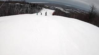
Dr. Doug is a 852 m blue difficulty singletrack trail located near Blue Mountain Resort Ontario. This downhill ski only trail. Winter use: Classic snow grooming.

Recent Activity on Trail

Past Week
  • 0 rides
  •  
6 Months
  • 92 rides
  • 19 miles avg distance
All
  • 355 rides
  •  
c1c2c3c4
January
February
March
April
May
June
July
August
September
October
November
December
update trails status or condition

Dr. Doug Trail Reports

statusdatedescription
Dec 18, 2019 @ 5:40am
Dec 18, 2019
more »
Status:
on Dec 18, 2019
Snow Covered
Avg: 3.09 (2 votes)
Your vote: 0

view (5,203)
close
3D
Trail Conditions
  • Unknown
  • Snow Groomed
  • Snow Packed
  • Snow Covered
  • Snow Cover Partial
  • Freeze/thaw Cycle
  • Icy
  • Prevalent Mud
  • Wet
  • Variable
  • Ideal
  • Dry
  • Very Dry
Trail Flow (Ridden Direction)
Trailforks scans users ridelogs to determine the most popular direction each trail is ridden. A good flowing trail network will have most trails flowing in a single direction according to their intension.
The colour categories are based on what percentage of riders are riding a trail in its intended direction.
  • > 96%
  • > 90%
  • > 80%
  • > 70%
  • > 50%
  • < 50%
  • bi-directional trail
  • no data
Trail Last Ridden
Trailforks scans ridelogs to determine the last time a trail was ridden.
  • < 2 days
  • < 1 week
  • < 2 weeks
  • < 1 month
  • < 6 months
  • > 6 months
Trail Ridden Direction
The intended direction a trail should be ridden.
  • Downhill Only
  • Downhill Primary
  • Both Directions
  • Uphill Primary
  • Uphill Only
  • One Direction
Contribute Details
Colors indicate trail is missing specified detail.
  • Description
  • Photos
  • Description & Photos
  • Videos
Trail Popularity ?
Trailforks scans ridelogs to determine which trails are ridden the most in the last 9 months. Trails are compared with nearby trails in the same city region with a possible 25 colour shades. Think of this as a heatmap, more rides = more kinetic energy = warmer colors.
  • most popular
  • popular
  • less popular
  • not popular
ATV/ORV/OHV Filter
Max Vehicle Width
inches
US Cell Coverage
Legend
cell carrier legend

Radar Time
Activity Recordings
Trailforks uses anonymized public activity data. ?
Activity Recordings
Trailforks uses anonymized public activity data. ?
Personal Heatmap
Activity Types
all / none
Options
2
Date range month
Winter Trails
Warning A routing network for winter maps does not exist. Selecting trails using the winter trails layer has been disabled.
Missing Trails
Most Popular
Least Popular
Trails are colored based on popularity. The more popular a trail is, the more red. Less popular trails trend towards green.
Jump Magnitude Heatmap
Heatmap of where riders jump on trails. Zoom in to see individual jumps, click circles to view jump details.
BC Backroad Status

Service Road Atlas is a free to use, community-driven service for viewing and creating reports on the numerous back-country service roads around B.C. and Alberta.

map legend
Slope Aspect
Direction the slope faces
Flat N NE E SE S SW W NW
Trails Deemphasized
Trails are shown in grey.
disable
Only show trails with no bike usage.
Enable
Suggested Layers
Based on selected activity type

    Save the current map location and zoom level as your default home location whenever this page is loaded.

    Save
        Directions to dr-doug trailhead (44.494536, -80.316510)

        Photos

        No photos have been added for Dr. Doug yet, add a photo.

        Videos

        2 more »
        dr doug to village
        2:38 | 174 | Dec 23, 2020 , Blue Mountain Resort
        dr.doug blue mountain ski
        0:55 | 805 | Oct 14, 2019 , Blue Mountain Resort

        Reviews / Comments

        No reviews yet, be the first to write a review or ask a question.
        Use trail reports to comment on trail conditions.


        We hope you've been enjoying Trailforks!

        Create a FREE account to view trail comments and much more.

        This trails GPS track was originally sourced from OpenStreetMap and will always be available for download in OSM Format.

        Frequently Asked Questions About Dr. Doug

        Where is Dr. Doug located?
        Dr. Doug is located in Blue Mountain Ski Resort, Blue Mountain Resort, Ontario, Canada. It is part of the Blue Mountain Ski Resort trail network. The trailhead is located at coordinates 44.49454, -80.31651.
        How hard is Dr. Doug?
        Dr. Doug is rated as Blue difficulty. The average grade is 20.575%.
        What is the elevation gain for Dr. Doug?
        The trail has 575 ft of elevation descent. The elevation ranges from 773 ft to 1,347 ft.
        Is Dr. Doug a point to point trail?
        Dr. Doug is not a point to point trail. The direction is Both Directions. The trail type is singletrack.

        Hit the Trail

        Open in App

        Get this trail on your phone instantly.
        open trail in app

        Download Trail

        Save to wishlist, Garmin & download.
        save the trail

        Find Related Routes

        Find routes and users activities that include this trail.
        find routes for this trail

        You must enter a description before submitting.