more stats
1,949 ft
Distance
-413 ft
Descent
00:17:01
Avg time
-413 ft
Altitude change
2,844 ft
Altitude min
3,258 ft
Altitude max
3,258 ft
Altitude start
2,844 ft
Altitude end
-21.2%
Grade
-55.1%
Grade max
-4.5%
Grade min
23 ft
Distance climb
1,926 ft
Distance down
00:17:01
Avg time

Dr. No Details

  • Activities
    • Mountain Bike
    • E-Bike
  • Riding Area
    Gillard
    Kelowna, British Columbia
  • Difficulty Rating
  • Voted Difficulty
    Double Black Diamond (2 votes)
  • Local Popularity
    50 in Mountain Biking [+]
    • 55 in E-Biking
  • Global Ranking
    #80182 in Mountain Biking [+]
    • #75431 in E-Biking
  • Trail Type
    Singletrack
  • Bike Type
    AM
  • Direction
    Downhill Only
    Popular Direction Shown
  • Climb Difficulty
    Double Black Diamond
  • Physical Rating
    Extreme
  • Dogs Allowed
    Yes
  • eBike Allowed
  • TTFs on Trail
    Log Ride, Rock Face, Rock Garden
  • Land Owner
    Rec Sites and Trail BC

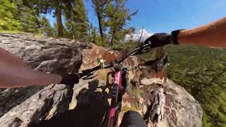
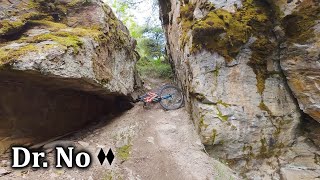
A time-honoured test-piece of steep, technical riding, Dr. No plummets through some of the coolest natural features around. Demanding cruxes leave little room for error, but there is time to gather one's breath in between. Have at

Local Trail Association
Traditionally Indigenous Territory

Recent Activity on Trail

Past Week
  • 0 rides
  •  
6 Months
  • 5 rides
  • 8 miles avg distance
All
  • 27 rides
  • Last: May 22, 2026
c1c2c3c4
January
February
March
April
May
June
July
August
September
October
November
December
update trails status or condition

Dr. No Trail Reports

statusdatedescription
Apr 5, 2026 @ 7:25pm (America/Vancouver)
Apr 5, 2026
reporter
Oct 3, 2024 @ 6:42pm
Oct 3, 2024
Apr 28, 2024 @ 1:34pm
Apr 28, 2024
Raked and buffed. Ready to ride.
Apr 21, 2024 @ 1:05pm
Apr 21, 2024
reporter Got the rest of those trees out of the way. good to go.
Apr 18, 2024 @ 8:02am
Apr 18, 2024
Was in the area and removed dead fall from the lower half of the trail. Right near the access road I created a path through but there are a number...
more »
Status:
on Apr 5, 2026
Ideal
Avg: 4.66 (12 votes)
Your vote: 0

view (177)
close
3D
Trail Conditions
  • Unknown
  • Snow Groomed
  • Snow Packed
  • Snow Covered
  • Snow Cover Partial
  • Freeze/thaw Cycle
  • Icy
  • Prevalent Mud
  • Wet
  • Variable
  • Ideal
  • Dry
  • Very Dry
Trail Flow (Ridden Direction)
Trailforks scans users ridelogs to determine the most popular direction each trail is ridden. A good flowing trail network will have most trails flowing in a single direction according to their intension.
The colour categories are based on what percentage of riders are riding a trail in its intended direction.
  • > 96%
  • > 90%
  • > 80%
  • > 70%
  • > 50%
  • < 50%
  • bi-directional trail
  • no data
Trail Last Ridden
Trailforks scans ridelogs to determine the last time a trail was ridden.
  • < 2 days
  • < 1 week
  • < 2 weeks
  • < 1 month
  • < 6 months
  • > 6 months
Trail Ridden Direction
The intended direction a trail should be ridden.
  • Downhill Only
  • Downhill Primary
  • Both Directions
  • Uphill Primary
  • Uphill Only
  • One Direction
Contribute Details
Colors indicate trail is missing specified detail.
  • Description
  • Photos
  • Description & Photos
  • Videos
Trail Popularity ?
Trailforks scans ridelogs to determine which trails are ridden the most in the last 9 months. Trails are compared with nearby trails in the same city region with a possible 25 colour shades. Think of this as a heatmap, more rides = more kinetic energy = warmer colors.
  • most popular
  • popular
  • less popular
  • not popular
ATV/ORV/OHV Filter
Max Vehicle Width
inches
US Cell Coverage
Legend
cell carrier legend

Radar Time
Activity Recordings
Trailforks uses anonymized public activity data. ?
Activity Recordings
Trailforks uses anonymized public activity data. ?
Personal Heatmap
Activity Types
all / none
Options
2
Date range month
Winter Trails
Warning A routing network for winter maps does not exist. Selecting trails using the winter trails layer has been disabled.
Missing Trails
Most Popular
Least Popular
Trails are colored based on popularity. The more popular a trail is, the more red. Less popular trails trend towards green.
Jump Magnitude Heatmap
Heatmap of where riders jump on trails. Zoom in to see individual jumps, click circles to view jump details.
BC Backroad Status

Service Road Atlas is a free to use, community-driven service for viewing and creating reports on the numerous back-country service roads around B.C. and Alberta.

map legend
Slope Aspect
Direction the slope faces
Flat N NE E SE S SW W NW
Trails Deemphasized
Trails are shown in grey.
disable
Only show trails with no bike usage.
Enable
Suggested Layers
Based on selected activity type

    Save the current map location and zoom level as your default home location whenever this page is loaded.

    Save
        Directions to dr-no trailhead (49.772860, -119.452550)

        Photos

        17 more »
        105 |
        Oct 3, 2024 @ 8:34pm
        Oct 3, 2024
        140 |
        May 16, 2024 @ 2:28pm
        May 16, 2024
        314 |
        May 7, 2021 @ 8:59am
        May 7, 2021
        486 |
        Sep 30, 2019 @ 10:17am
        Sep 30, 2019

        Videos

        5 more »
        Dr. No, Gillard, Kelowna, BC
        4:58 | 334 | Jun 27, 2024 , Kelowna
        Not For the Faint of Heart | Dr No - Gillard
        5:09 | 145 | Jun 11, 2024 , Kelowna
        Dr No after the rebuild
        3:31 | 1627 | May 27, 2013 , Kelowna
        Dr. No REDUX
        4:13 | 664 | Jan 20, 2012 , Kelowna

        Technical Trail Features (TTF)

        Routes with this trail

        3 miles 49 ft 12
        This is a steep route for Gillard. steeper then the easy route, so you know its steep

        1 Review & Comments


        We hope you've been enjoying Trailforks!

        Create a FREE account to view trail comments and much more.

        • By smokeTF Pro Simpcw & contributors
        • #19136 - 5,084 views

        Frequently Asked Questions About Dr. No

        Where is Dr. No located?
        Dr. No is located in Gillard, Kelowna, British Columbia, Canada. It is part of the Gillard trail network. The trailhead is located at coordinates 49.77286, -119.45255.
        How hard is Dr. No?
        Dr. No is rated as Double Black Diamond difficulty. The physical rating is Extreme. The average grade is 21.2%. The climb difficulty is rated Double Black Diamond.
        What is the elevation gain for Dr. No?
        The trail has 126 m of elevation descent. The elevation ranges from 867 m to 993 m.
        Is Dr. No a point to point trail?
        Yes, Dr. No is a point to point trail. The direction is Downhill Only. The trail type is singletrack.

        Hit the Trail

        Open in App

        Get this trail on your phone instantly.
        open trail in app

        Download Trail

        Save to wishlist, Garmin & download.
        save the trail

        Find Related Routes

        Find routes and users activities that include this trail.
        find routes for this trail

        You must enter a description before submitting.