more stats
6.6 miles
Distance
241 ft
Climb
-2,558 ft
Descent
00:58:27
Avg time
-2,317 ft
Altitude change
8,427 ft
Altitude min
10,910 ft
Altitude max
10,743 ft
Altitude start
8,425 ft
Altitude end
-6.7%
Grade
-53.9%
Grade max
13.8%
Grade min
1 mile
Distance climb
5 miles
Distance down
768 ft
Distance flat
00:58:27
Avg time

Dr. Park Details

  • Activities
    • Mountain Bike
    • Hike
    • Trail Running
  • Riding Area
    Spring Creek
    Crested Butte, Colorado
  • Ref Number
    #424
  • Difficulty Rating
  • Voted Difficulty
    Black Diamond (1 vote)
  • Local Popularity
    100 in Mountain Biking [+]
    • 75 in Trail Running
    • 70 in Hiking
  • Global Ranking
    #330 in Mountain Biking [+]
    • #167 in Trail Running
    • #1234 in Hiking
  • Trail Type
    Singletrack
  • Direction
    Downhill Primary
    Popular Direction Shown
  • Climb Difficulty
    Black Diamond
  • Physical Rating
    Moderate
  • Dogs Allowed
    Yes
  • eBike Allowed

***Potential for Access Restrictions*** - Due to lack of consideration from vehicular traffic along Spring Creek Road (CR744)

With an increase in shuttle traffic up Spring Creek Road and countless reports of speeding, homeowners are becoming unhappy with the situation. Please be respectful of homeowners and your fellow riders whom ride the full loop. Riders don't want to choke on your dust as you go speeding by in your vehicle. So please be considerate of the sensitive situation along Spring Creek Road, do what you can to minimize shuttle traffic and drive at appropriate speeds. Lets do what we can to retain access to the numerous great trails in the Spring Creek area.

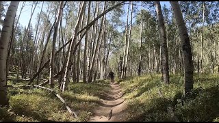
This downhill trail is awesome It starts of with a slow roll through a thick forest and is a bit of a short climb. The forest trail has cool wood crossings to avoid sections that typically stay muddy. It opens up to a meadow where you have the option to do the Doctor Park Bonus Loop.

The descent starts at this meadow and is fast through the meadow then quickly descends down and starts to get more and more rocky and loose. Rocks can be doubled up to keep up the speed. The middle section is blazing fast, kind of a smooth hardpacked sandy surface that you move fast through and can drift around the turns. Little water bars give you a little boost here and there.

The 3rd section opens up into a wide view of the valley before quickly descending the tight switchbacks that are reinforced with embedded cinder block. This section has some big boulders and is a fun and technical descent through the switchbacks until you dump out at the campgrounds trailhead.

Not open to e bikes.

Access Info

If you choose NOT to do the full 20 mile loop via the pedal up Spring Creek Road (CR744) thus choose to shuttle Dr. Park please park on the north side of spring creek. Do NOT attempt to cross the creek and drive up Doctor Gulch Road #7554, there has been a heavy and noticeable impact from vehicles driving the gulch road and parking at the delicate meadow at the start of the singletrack. Access to Dr. Park could be threatened if the trend continues.

Disclaimer

Winter CLOSURE: This trail is closed every winter until the Friday before Memorial Day for big game wintering habitat.

Trail Supporters
Local Trail Association
Traditionally Indigenous Territory

Recent Activity on Trail

Past Week
  • 6 rides
  • 15 miles average
6 Months
  • 38 rides
  • 18 miles avg distance
All
  • 517 rides
  • Last: Jun 29, 2026
c1c2c3c4
January
February
March
April
May
June
July
August
September
October
November
December
update trails status or condition

Dr. Park Trail Reports

statusdatedescription
Jun 15, 2026 @ 10:23am (America/Denver)
Jun 15, 2026
Jun 6, 2026 @ 10:01am (America/Denver)
Jun 6, 2026
Oct 1, 2025 @ 6:28pm (America/Denver)
Oct 1, 2025
Fall time all time.
Sep 21, 2025 @ 12:25pm (America/Denver)
Sep 21, 2025
Tree down mid trail before you enter the alpine section.
Aug 30, 2025 @ 12:17pm
Aug 30, 2025
The first traverse section before the downhill was quite wet, and muddy in spots, kinda on the edge of being too muddy to ride. But it was...
more »
Status:
on Jun 15, 2026
Dry
Avg: 4.62 (62 votes)
Your vote: 0

view (3,939)
close
3D
Trail Conditions
  • Unknown
  • Snow Groomed
  • Snow Packed
  • Snow Covered
  • Snow Cover Partial
  • Freeze/thaw Cycle
  • Icy
  • Prevalent Mud
  • Wet
  • Variable
  • Ideal
  • Dry
  • Very Dry
Trail Flow (Ridden Direction)
Trailforks scans users ridelogs to determine the most popular direction each trail is ridden. A good flowing trail network will have most trails flowing in a single direction according to their intension.
The colour categories are based on what percentage of riders are riding a trail in its intended direction.
  • > 96%
  • > 90%
  • > 80%
  • > 70%
  • > 50%
  • < 50%
  • bi-directional trail
  • no data
Trail Last Ridden
Trailforks scans ridelogs to determine the last time a trail was ridden.
  • < 2 days
  • < 1 week
  • < 2 weeks
  • < 1 month
  • < 6 months
  • > 6 months
Trail Ridden Direction
The intended direction a trail should be ridden.
  • Downhill Only
  • Downhill Primary
  • Both Directions
  • Uphill Primary
  • Uphill Only
  • One Direction
Contribute Details
Colors indicate trail is missing specified detail.
  • Description
  • Photos
  • Description & Photos
  • Videos
Trail Popularity ?
Trailforks scans ridelogs to determine which trails are ridden the most in the last 9 months. Trails are compared with nearby trails in the same city region with a possible 25 colour shades. Think of this as a heatmap, more rides = more kinetic energy = warmer colors.
  • most popular
  • popular
  • less popular
  • not popular
ATV/ORV/OHV Filter
Max Vehicle Width
inches
US Cell Coverage
Legend
cell carrier legend

Radar Time
Activity Recordings
Trailforks uses anonymized public activity data. ?
Activity Recordings
Trailforks uses anonymized public activity data. ?
Personal Heatmap
Activity Types
all / none
Options
2
Date range month
Winter Trails
Warning A routing network for winter maps does not exist. Selecting trails using the winter trails layer has been disabled.
Missing Trails
Most Popular
Least Popular
Trails are colored based on popularity. The more popular a trail is, the more red. Less popular trails trend towards green.
Jump Magnitude Heatmap
Heatmap of where riders jump on trails. Zoom in to see individual jumps, click circles to view jump details.
BC Backroad Status

Service Road Atlas is a free to use, community-driven service for viewing and creating reports on the numerous back-country service roads around B.C. and Alberta.

map legend
Slope Aspect
Direction the slope faces
Flat N NE E SE S SW W NW
Trails Deemphasized
Trails are shown in grey.
disable
Only show trails with no bike usage.
Enable
Suggested Layers
Based on selected activity type

    Save the current map location and zoom level as your default home location whenever this page is loaded.

    Save
        Directions to dr-park trailhead (38.800760, -106.718900)

        Photos

        56 more »
        568 |
        Aug 13, 2018 @ 1:29pm
        Aug 13, 2018
        472 |
        Aug 13, 2018 @ 1:29pm
        Aug 13, 2018
        79 |
        Sep 3, 2025 @ 10:08am
        Sep 3, 2025
        94 |
        Sep 3, 2025 @ 10:05am
        Sep 3, 2025

        Videos

        13 more »
        youtuber Doctors Park With Charlie Harrison & Nik...
        17:58 | 770 | Jul 8, 2020 , Crested Butte
        youtuber Mountain Biking Doctor Park // There's A...
        22:41 | 1023 | Aug 18, 2020 , Crested Butte
        youtuber The longest climb of my life.
        10:15 | 726 | Sep 3, 2020 , Crested Butte
        Epic ride down Dr. Park trail Crested Butte
        23:09 | 175 | May 6, 2024 , Crested Butte

        Routes with this trail

        4.0 19 miles 2,686 ft 4
        4.0 7 miles 241 ft 1 Point to Point
        Doctor Park is located in Taylor Canyon, and accessed via a dirt road climb that some people will opt to...
        5.0 28 miles 4,073 ft 8 Shuttled
        This route combines three of the best downhill trails in the Spring Creek area resulting in a highly...

        26 Reviews & Comments


        We hope you've been enjoying Trailforks!

        Create a FREE account to view trail comments and much more.

        • By toddTF Pro Trailforks & contributors
        • #22833 - 18,395 views

        Frequently Asked Questions About Dr. Park

        Where is Dr. Park located?
        Dr. Park is located in Spring Creek, Crested Butte, Colorado, United States. It is part of the Spring Creek trail network. The trailhead is located at coordinates 38.80076, -106.7189.
        How hard is Dr. Park?
        Dr. Park is rated as Black Diamond difficulty. The physical rating is Moderate. The average grade is 6.7%. The climb difficulty is rated Black Diamond.
        What is the elevation gain for Dr. Park?
        Dr. Park has 241 ft of elevation gain. The trail has 2,558 ft of elevation descent. The elevation ranges from 8,427 ft to 10,910 ft.
        Is Dr. Park a point to point trail?
        Dr. Park is not a point to point trail. The direction is Downhill Primary. The trail type is singletrack.

        Hit the Trail

        Open in App

        Get this trail on your phone instantly.
        open trail in app

        Download Trail

        Save to wishlist, Garmin & download.
        save the trail

        Find Related Routes

        Find routes and users activities that include this trail.
        find routes for this trail

        You must enter a description before submitting.