more stats
4,797 ft
Distance
10 ft
Climb
-53 ft
Descent
00:06:19
Avg time
-45 ft
Altitude change
884 ft
Altitude min
929 ft
Altitude max
928 ft
Altitude start
883 ft
Altitude end
-0.9%
Grade
-10.2%
Grade max
7.8%
Grade min
381 ft
Distance climb
1,316 ft
Distance down
3,054 ft
Distance flat
00:06:19
Avg time

Drift Details

  • Activities
    • Mountain Bike
    • E-Bike
    • Hike
    • Trail Running
    • Snowshoe
  • Riding Area
    Trowbridge Forest
    Thunder Bay, Ontario
  • AKA
    Hill Top Connector
  • Difficulty Rating
  • Local Popularity
    95 in Mountain Biking [+]
    • 75 in E-Biking
    • 55 in Trail Running
    • 85 in Hiking
    • 95 in Snowshoeing
  • Global Ranking
    #40821 in Mountain Biking [+]
    • #111803 in Trail Running
    • #54587 in Hiking
    • #873 in Snowshoeing
  • Hiking SAC Scale
    T1 Hiking
  • Trail Type
    Singletrack
  • Bike Type
    AM, XC
  • Direction
    Both Directions
    Popular Direction Shown
  • Climb Difficulty
    Blue
  • Physical Rating
    Moderate
  • Trail Visibility
    Always easy to follow
  • Season
    All year
  • Dogs Allowed
    Yes
  • eBike Allowed
    Yes up to Class 1
  • TTFs on Trail
    Drop, Jump, Gap Jump, Pump Track, Rock Garden
  • Year Opened
    2019

Recently completed this August, Drift is a taste of what's to come in the future of mountain biking in Trowbridge Forest.

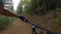
Starting from the top, the trail winds through the open boreal forest filled with lots of large berms and rollers. Keep an eye out for lots of optional features primary of rock that will allow every trip down the trail to be unique in either direction

This trail was made possible with the support and funding from the Thunder Bay Community Economic Development Commission, Thunder Bay City Park & Open Spaces Division, and your generous donations.

Trail Supporters
Local Trail Association

Recent Activity on Trail

Past Week
  • 15 rides
  • 9 miles average
6 Months
  • 83 rides
  • 10 miles avg distance
All
  • 1,205 rides
  • Last: Jun 22, 2026
c1c2c3c4
January
February
March
April
May
June
July
August
September
October
November
December
update trails status or condition

Drift Trail Reports

statusdatedescription
Jun 14, 2026 @ 10:28am (America/Vancouver)
Jun 14, 2026
Tree has been cleared, trail is in overall good shape.
May 10, 2026 @ 5:00pm (America/Toronto)
May 10, 2026
Tree down
Dec 29, 2025 @ 2:41pm (America/Toronto)
Dec 29, 2025
tree across trail close to north end on the side hill, low but can squeeze underneath
May 10, 2025 @ 2:44pm
May 10, 2025
reporter Trails are in good shape. There is some winter debris on some trails so ride with care. Please ride through any puddles.
Apr 26, 2025 @ 1:57pm
Apr 26, 2025
reporter The spring thaw is in full effect. Please avoid the trails
more »
Status:
on Jun 14, 2026
Variable
Avg: 4.26 (9 votes)
Your vote: 0

view (6,984)
close
3D
Trail Conditions
  • Unknown
  • Snow Groomed
  • Snow Packed
  • Snow Covered
  • Snow Cover Partial
  • Freeze/thaw Cycle
  • Icy
  • Prevalent Mud
  • Wet
  • Variable
  • Ideal
  • Dry
  • Very Dry
Trail Flow (Ridden Direction)
Trailforks scans users ridelogs to determine the most popular direction each trail is ridden. A good flowing trail network will have most trails flowing in a single direction according to their intension.
The colour categories are based on what percentage of riders are riding a trail in its intended direction.
  • > 96%
  • > 90%
  • > 80%
  • > 70%
  • > 50%
  • < 50%
  • bi-directional trail
  • no data
Trail Last Ridden
Trailforks scans ridelogs to determine the last time a trail was ridden.
  • < 2 days
  • < 1 week
  • < 2 weeks
  • < 1 month
  • < 6 months
  • > 6 months
Trail Ridden Direction
The intended direction a trail should be ridden.
  • Downhill Only
  • Downhill Primary
  • Both Directions
  • Uphill Primary
  • Uphill Only
  • One Direction
Contribute Details
Colors indicate trail is missing specified detail.
  • Description
  • Photos
  • Description & Photos
  • Videos
Trail Popularity ?
Trailforks scans ridelogs to determine which trails are ridden the most in the last 9 months. Trails are compared with nearby trails in the same city region with a possible 25 colour shades. Think of this as a heatmap, more rides = more kinetic energy = warmer colors.
  • most popular
  • popular
  • less popular
  • not popular
ATV/ORV/OHV Filter
Max Vehicle Width
inches
US Cell Coverage
Legend
cell carrier legend

Radar Time
Activity Recordings
Trailforks uses anonymized public activity data. ?
Activity Recordings
Trailforks uses anonymized public activity data. ?
Personal Heatmap
Activity Types
all / none
Options
2
Date range month
Winter Trails
Warning A routing network for winter maps does not exist. Selecting trails using the winter trails layer has been disabled.
Missing Trails
Most Popular
Least Popular
Trails are colored based on popularity. The more popular a trail is, the more red. Less popular trails trend towards green.
Jump Magnitude Heatmap
Heatmap of where riders jump on trails. Zoom in to see individual jumps, click circles to view jump details.
BC Backroad Status

Service Road Atlas is a free to use, community-driven service for viewing and creating reports on the numerous back-country service roads around B.C. and Alberta.

map legend
Slope Aspect
Direction the slope faces
Flat N NE E SE S SW W NW
Trails Deemphasized
Trails are shown in grey.
disable
Only show trails with no bike usage.
Enable
Suggested Layers
Based on selected activity type

    Save the current map location and zoom level as your default home location whenever this page is loaded.

    Save
        Directions to drift-135260 trailhead (48.482940, -89.207540)

        Photos

        19 more »
        159 |
        Feb 12, 2023 @ 8:20pm
        Feb 12, 2023
        305 |
        Sep 26, 2021 @ 2:02pm
        Sep 26, 2021
        336 |
        Sep 27, 2021 @ 11:57am
        Sep 27, 2021
        291 |
        Sep 26, 2021 @ 7:38pm
        Sep 26, 2021

        Videos

        1 more »
        Drift drop
        0:11 | 220 | Sep 4, 2023 , Thunder Bay

        Routes with this trail

        15 miles 1,025 ft 43 Loop
        Long course for the 2023 Blacksheep Poker Ride.
        5 miles 312 ft 4
        Fun Enduro Ride!!!!!!! 2022
        18 miles 1,221 ft 50 Loop
        Both routes for printing for the Blacksheep Poker Ride.

        1 Review & Comments


        We hope you've been enjoying Trailforks!

        Create a FREE account to view trail comments and much more.

        • By WanderingManTF Pro BSMTB & contributors
        • #135260 - 3,279 views

        Frequently Asked Questions About Drift

        Where is Drift located?
        Drift is located in Trowbridge Forest, Thunder Bay, Ontario, Canada. It is part of the Trowbridge Forest trail network. The trailhead is located at coordinates 48.48294, -89.20754.
        How hard is Drift?
        Drift is rated as Blue difficulty. The physical rating is Moderate. The average grade is 0.9%. The climb difficulty is rated Blue.
        What is the elevation gain for Drift?
        Drift has 10 ft of elevation gain. The trail has 53 ft of elevation descent. The elevation ranges from 884 ft to 929 ft.
        Is Drift a point to point trail?
        Drift is not a point to point trail. The direction is Both Directions. The trail type is singletrack.

        Hit the Trail

        Open in App

        Get this trail on your phone instantly.
        open trail in app

        Download Trail

        Save to wishlist, Garmin & download.
        save the trail

        Find Related Routes

        Find routes and users activities that include this trail.
        find routes for this trail

        You must enter a description before submitting.