more stats
3,698 ft
Distance
-938 ft
Descent
00:07:49
Avg time
-939 ft
Altitude change
2,299 ft
Altitude min
3,239 ft
Altitude max
3,239 ft
Altitude start
2,300 ft
Altitude end
-25.4%
Grade
-63.5%
Grade max
-6.6%
Grade min
16 ft
Distance climb
3,684 ft
Distance down
00:07:49
Avg time

Drifter Details

  • Activities
    • Mountain Bike
    • Winter Fat Bike
    • Hike
    • Trail Running
  • Riding Area
    Salmo Ski Hill Trails
    Salmo, British Columbia
  • Difficulty Rating
  • Local Popularity
    65 in Mountain Biking [+]
    • 5 in Trail Running
    • 5 in Hiking
  • Global Ranking
    #85250 in Mountain Biking [+]
    • #137141 in Trail Running
    • #130891 in Hiking
  • Trail Type
    Singletrack
  • Bike Type
    DH, AM, XC
  • Season
    3 season
  • Dogs Allowed
    Yes
  • Ride in Rain
    Yes
  • Land Owner

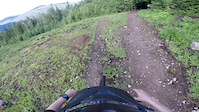
Raw and old school, built before the trail society existed. Once a loamer, still a super fun rocky and rooty drifter. One steep pitch mid trail with no easy out, a couple drops and jumps all with ride arounds, and a slightly spicy exit to the ski hill road.

Access Info

Climb either Sunset east or west then take Sunrise trail to link up to Drifter the first section of True Blue. Drifter is a sharp left after the rock roll on True Blue.

Local Trail Association

Recent Activity on Trail

Past Week
  • 0 rides
  •  
6 Months
  • 21 rides
  • 9 miles avg distance
All
  • 129 rides
  • Last: Jun 10, 2026
c1c2c3c4
January
February
March
April
May
June
July
August
September
October
November
December
update trails status or condition

Drifter Trail Reports

statusdatedescription
May 7, 2026 @ 5:18pm (America/Vancouver)
May 7, 2026
reporter Yes officially clear!! Enjoy
Apr 26, 2026 @ 11:08am (America/Vancouver)
Apr 26, 2026
Mar 22, 2026 @ 11:11am (America/Vancouver)
Mar 22, 2026
reporter Drifter was hit hard by December and January storms. We are working to get cleared and safe and rideable but not open yet.
Mar 21, 2026 @ 2:38pm (America/Vancouver)
Mar 21, 2026
Multiple trees down
Mar 21, 2026 @ 2:36pm (America/Vancouver)
Mar 21, 2026
more »
Status:
on May 7, 2026
Ideal
Avg: 4.45 (7 votes)
Your vote: 0

view (550)
close
3D
Trail Conditions
  • Unknown
  • Snow Groomed
  • Snow Packed
  • Snow Covered
  • Snow Cover Partial
  • Freeze/thaw Cycle
  • Icy
  • Prevalent Mud
  • Wet
  • Variable
  • Ideal
  • Dry
  • Very Dry
Trail Flow (Ridden Direction)
Trailforks scans users ridelogs to determine the most popular direction each trail is ridden. A good flowing trail network will have most trails flowing in a single direction according to their intension.
The colour categories are based on what percentage of riders are riding a trail in its intended direction.
  • > 96%
  • > 90%
  • > 80%
  • > 70%
  • > 50%
  • < 50%
  • bi-directional trail
  • no data
Trail Last Ridden
Trailforks scans ridelogs to determine the last time a trail was ridden.
  • < 2 days
  • < 1 week
  • < 2 weeks
  • < 1 month
  • < 6 months
  • > 6 months
Trail Ridden Direction
The intended direction a trail should be ridden.
  • Downhill Only
  • Downhill Primary
  • Both Directions
  • Uphill Primary
  • Uphill Only
  • One Direction
Contribute Details
Colors indicate trail is missing specified detail.
  • Description
  • Photos
  • Description & Photos
  • Videos
Trail Popularity ?
Trailforks scans ridelogs to determine which trails are ridden the most in the last 9 months. Trails are compared with nearby trails in the same city region with a possible 25 colour shades. Think of this as a heatmap, more rides = more kinetic energy = warmer colors.
  • most popular
  • popular
  • less popular
  • not popular
ATV/ORV/OHV Filter
Max Vehicle Width
inches
US Cell Coverage
Legend
cell carrier legend

Radar Time
Activity Recordings
Trailforks uses anonymized public activity data. ?
Activity Recordings
Trailforks uses anonymized public activity data. ?
Personal Heatmap
Activity Types
all / none
Options
2
Date range month
Winter Trails
Warning A routing network for winter maps does not exist. Selecting trails using the winter trails layer has been disabled.
Missing Trails
Most Popular
Least Popular
Trails are colored based on popularity. The more popular a trail is, the more red. Less popular trails trend towards green.
Jump Magnitude Heatmap
Heatmap of where riders jump on trails. Zoom in to see individual jumps, click circles to view jump details.
BC Backroad Status

Service Road Atlas is a free to use, community-driven service for viewing and creating reports on the numerous back-country service roads around B.C. and Alberta.

map legend
Slope Aspect
Direction the slope faces
Flat N NE E SE S SW W NW
Trails Deemphasized
Trails are shown in grey.
disable
Only show trails with no bike usage.
Enable
Suggested Layers
Based on selected activity type

    Save the current map location and zoom level as your default home location whenever this page is loaded.

    Save
        Directions to drifter-41753 trailhead (49.175770, -117.300110)

        Photos

        19 more »
        357 |
        Jun 5, 2017 @ 9:44pm
        Jun 5, 2017
        365 |
        Jun 5, 2017 @ 9:44pm
        Jun 5, 2017
        346 |
        Jun 5, 2017 @ 9:44pm
        Jun 5, 2017
        384 |
        Jun 5, 2017 @ 9:44pm
        Jun 5, 2017

        Videos

        2 more »
        youtuber Salmo's Best Kept Secret? // Salmo Ski Hill -...
        8:55 | 860 | Mar 2, 2021 , Salmo
        Drifter, Salmo Ski Hill
        4:01 | 337 | Jun 21, 2020 , Salmo

        Routes with this trail

        9 miles 3,183 ft 13 Race
        Salmo Virtual Enduro October 4th-12th Ride True Blue, Full Inducer and Drifter using Strava to record your...
        1.0 10 miles 3,225 ft 14 Loop Race
        SALMO ENDURO COURSE STAGE 1 FULL STAGE 2 STAGE 3 FULL TO SUNSET FINISH

        3 Reviews & Comments


        We hope you've been enjoying Trailforks!

        Create a FREE account to view trail comments and much more.

        • By rthomy & contributors
        • #41753 - 3,730 views

        Frequently Asked Questions About Drifter

        Where is Drifter located?
        Drifter is located in Salmo Ski Hill Trails, Salmo, British Columbia, Canada. It is part of the Salmo Ski Hill Trails trail network. The trailhead is located at coordinates 49.17577, -117.30011.
        How hard is Drifter?
        Drifter is rated as Black Diamond difficulty. The average grade is 25.4%.
        What is the elevation gain for Drifter?
        The trail has 286 m of elevation descent. The elevation ranges from 701 m to 987 m.
        How long is Drifter?
        Drifter is 1.1 km long. The trail type is singletrack.

        Hit the Trail

        Open in App

        Get this trail on your phone instantly.
        open trail in app

        Download Trail

        Save to wishlist, Garmin & download.
        save the trail

        Find Related Routes

        Find routes and users activities that include this trail.
        find routes for this trail

        You must enter a description before submitting.