more stats
15.0 miles
Distance
340 ft
Climb
-339 ft
Descent
01:01:54
Avg time
1 ft
Altitude change
30 ft
Altitude min
75 ft
Altitude max
36 ft
Altitude start
37 ft
Altitude end
0.001%
Grade
-3.819%
Grade max
3.931%
Grade min
6 miles
Distance climb
6 miles
Distance down
3 miles
Distance flat
01:01:54
Avg time

Drunen Details

  • Activities
    • Mountain Bike
  • Riding Area
  • Difficulty Rating
  • Voted Difficulty
    Green (1 vote)
  • Local Popularity
    100 in Mountain Biking
  • Global Ranking
    #22959 in Mountain Biking
  • Trail Type
    Singletrack
  • Bike Type
    XC
  • Direction
    Both Directions
  • Climb Difficulty
    Green
  • Physical Rating
    Moderate
  • Season
    All season
  • Dogs Allowed
    Yes
  • Ride in Rain
    Yes

IMPORTANT: It's illegal to ride on this trail without a license. License fees are € 5.00/day, € 7.50/weekend or € 12.00/year (updated to 2018 fees). Riding on this trail without a license is on your own risk. Licenses can be bought at Café De Klinkert, Café De Roestelberg in Kaatsheuvel, Café De Rustende Jager in Biezenmortel and Café De Drie Linden in Giersbergen or check https://www.natuurmonumenten.nl/mountainbiken/verkooppunten-mtb-vignet

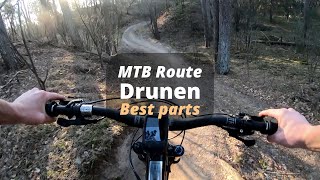
Challenging XC trail which can cause some problems for beginners. Lots of short climbs and descents for which you need a decent physical condition. Lot's of dry sand so it can handle a lot of water.

Access Info

trail can be started at the same place where the licenses can be bought.

Recent Activity on Trail

Past Week
  • 1 rides
  • 27 miles average
6 Months
  • 46 rides
  • 31 miles avg distance
All
  • 233 rides
  • Last: Jun 23, 2026
c1c2c3c4
January
February
March
April
May
June
July
August
September
October
November
December
update trails status or condition

Drunen Trail Reports

statusdatedescription
May 25, 2026 @ 10:25am (Europe/Amsterdam)
May 25, 2026
Mar 9, 2026 @ 11:50pm (Europe/Amsterdam)
Mar 9, 2026
Minor erosion (trail braiding, small ruts developing, brake bumps). Er is onderhoud gepleegd aan de west zijden hierdoor is deze mul. De...
May 31, 2025 @ 9:09am
May 31, 2025
Jun 19, 2024 @ 2:57am
Jun 19, 2024
Een aantal redelijk grote moerassen in de zwarte route. De escapes zijn door het bos aangelegd maar worden ook al zeer slecht. 80% goed, 20% zeer...
Mar 16, 2024 @ 3:28pm
Mar 16, 2024
Op een aantal Plekken, met name aan zuid west kant nog erg nat met flinke plassen. Met olifantenpaadjes is er omheen te rijden
more »
Status:
on May 25, 2026
Very Dry
Avg: 3.79 (13 votes)
Your vote: 0

view (3,445)
close
3D
Trail Conditions
  • Unknown
  • Snow Groomed
  • Snow Packed
  • Snow Covered
  • Snow Cover Partial
  • Freeze/thaw Cycle
  • Icy
  • Prevalent Mud
  • Wet
  • Variable
  • Ideal
  • Dry
  • Very Dry
Trail Flow (Ridden Direction)
Trailforks scans users ridelogs to determine the most popular direction each trail is ridden. A good flowing trail network will have most trails flowing in a single direction according to their intension.
The colour categories are based on what percentage of riders are riding a trail in its intended direction.
  • > 96%
  • > 90%
  • > 80%
  • > 70%
  • > 50%
  • < 50%
  • bi-directional trail
  • no data
Trail Last Ridden
Trailforks scans ridelogs to determine the last time a trail was ridden.
  • < 2 days
  • < 1 week
  • < 2 weeks
  • < 1 month
  • < 6 months
  • > 6 months
Trail Ridden Direction
The intended direction a trail should be ridden.
  • Downhill Only
  • Downhill Primary
  • Both Directions
  • Uphill Primary
  • Uphill Only
  • One Direction
Contribute Details
Colors indicate trail is missing specified detail.
  • Description
  • Photos
  • Description & Photos
  • Videos
Trail Popularity ?
Trailforks scans ridelogs to determine which trails are ridden the most in the last 9 months. Trails are compared with nearby trails in the same city region with a possible 25 colour shades. Think of this as a heatmap, more rides = more kinetic energy = warmer colors.
  • most popular
  • popular
  • less popular
  • not popular
ATV/ORV/OHV Filter
Max Vehicle Width
inches
US Cell Coverage
Legend
cell carrier legend

Radar Time
Activity Recordings
Trailforks uses anonymized public activity data. ?
Activity Recordings
Trailforks uses anonymized public activity data. ?
Personal Heatmap
Activity Types
all / none
Options
2
Date range month
Winter Trails
Warning A routing network for winter maps does not exist. Selecting trails using the winter trails layer has been disabled.
Missing Trails
Most Popular
Least Popular
Trails are colored based on popularity. The more popular a trail is, the more red. Less popular trails trend towards green.
Jump Magnitude Heatmap
Heatmap of where riders jump on trails. Zoom in to see individual jumps, click circles to view jump details.
BC Backroad Status

Service Road Atlas is a free to use, community-driven service for viewing and creating reports on the numerous back-country service roads around B.C. and Alberta.

map legend
Slope Aspect
Direction the slope faces
Flat N NE E SE S SW W NW
Trails Deemphasized
Trails are shown in grey.
disable
Only show trails with no bike usage.
Enable
Suggested Layers
Based on selected activity type

    Save the current map location and zoom level as your default home location whenever this page is loaded.

    Save
        Directions to drunen trailhead (51.639430, 5.148519)

        Photos

        147 more »
        62 |
        Jun 26, 2022 @ 11:14am
        Jun 26, 2022
        63 |
        Jun 26, 2022 @ 11:14am
        Jun 26, 2022
        42 |
        Jun 26, 2022 @ 11:14am
        Jun 26, 2022
        53 |
        Jun 26, 2022 @ 11:15am
        Jun 26, 2022

        Videos

        1 more »
        Best parts of MTB route Drunen
        12:31 | 184 | Jun 15, 2023 , Drunen

        Trail Lists

        1 Review & Comments


        We hope you've been enjoying Trailforks!

        Create a FREE account to view trail comments and much more.

        • By schralpcc & contributors
        • #9898 - 2,816 views

        Frequently Asked Questions About Drunen

        Where is Drunen located?
        Drunen is located in Drunen, Netherlands. It is part of the Drunen trail network. The trailhead is located at coordinates 51.63943, 5.14852.
        How hard is Drunen?
        Drunen is rated as Green difficulty. The physical rating is Moderate. The average grade is 0.001%. The climb difficulty is rated Green.
        What is the elevation gain for Drunen?
        Drunen has 340 ft of elevation gain. The trail has 339 ft of elevation descent. The elevation ranges from 30 ft to 75 ft.
        Is Drunen a point to point trail?
        Drunen is not a point to point trail. The direction is Both Directions. The trail type is singletrack.

        Hit the Trail

        Open in App

        Get this trail on your phone instantly.
        open trail in app

        Download Trail

        Save to wishlist, Garmin & download.
        save the trail

        Find Related Routes

        Find routes and users activities that include this trail.
        find routes for this trail

        You must enter a description before submitting.