more stats
4,567 ft
Distance
12 ft
Climb
-666 ft
Descent
00:07:58
Avg time
-653 ft
Altitude change
2,980 ft
Altitude min
3,633 ft
Altitude max
3,633 ft
Altitude start
2,979 ft
Altitude end
-14.3%
Grade
-38.7%
Grade max
10.6%
Grade min
200 ft
Distance climb
3,993 ft
Distance down
374 ft
Distance flat
00:07:58
Avg time

Duffman - Lower Details

  • Activities
    • Mountain Bike
  • Riding Area
    Whistler Mountain Bike Park
    Whistler, British Columbia
  • AKA
    Lower Duffman
  • Difficulty Rating
  • Local Popularity
    45 in Mountain Biking
  • Global Ranking
    #40194 in Mountain Biking
  • Trail Type
    Singletrack
  • Bike Type
    DH
  • Direction
    Downhill Only
    Popular Direction Shown
  • eBike Allowed
  • Land Owner

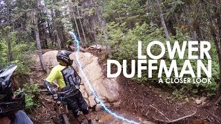
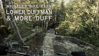
Dufman is a flowy downhill trail with rough rock patches at times, but generally it's on the easier side of a technical black diamond. Can ride it with an AM bike as well. No notable man-made features that I recall, mostly a natural trail.

Bike Park

Recent Activity on Trail

Past Week
  • 10 rides
  • 33 miles average
6 Months
  • 10 rides
  • 33 miles avg distance
All
  • 981 rides
  • Last: Jun 19, 2026
c1c2c3c4
January
February
March
April
May
June
July
August
September
October
November
December
update trails status or condition

Duffman - Lower Trail Reports

Status:
on Oct 18, 2025
Avg: 4.27 (57 votes)
Your vote: 0

view (6,672)
close
3D
Trail Conditions
  • Unknown
  • Snow Groomed
  • Snow Packed
  • Snow Covered
  • Snow Cover Partial
  • Freeze/thaw Cycle
  • Icy
  • Prevalent Mud
  • Wet
  • Variable
  • Ideal
  • Dry
  • Very Dry
Trail Flow (Ridden Direction)
Trailforks scans users ridelogs to determine the most popular direction each trail is ridden. A good flowing trail network will have most trails flowing in a single direction according to their intension.
The colour categories are based on what percentage of riders are riding a trail in its intended direction.
  • > 96%
  • > 90%
  • > 80%
  • > 70%
  • > 50%
  • < 50%
  • bi-directional trail
  • no data
Trail Last Ridden
Trailforks scans ridelogs to determine the last time a trail was ridden.
  • < 2 days
  • < 1 week
  • < 2 weeks
  • < 1 month
  • < 6 months
  • > 6 months
Trail Ridden Direction
The intended direction a trail should be ridden.
  • Downhill Only
  • Downhill Primary
  • Both Directions
  • Uphill Primary
  • Uphill Only
  • One Direction
Contribute Details
Colors indicate trail is missing specified detail.
  • Description
  • Photos
  • Description & Photos
  • Videos
Trail Popularity ?
Trailforks scans ridelogs to determine which trails are ridden the most in the last 9 months. Trails are compared with nearby trails in the same city region with a possible 25 colour shades. Think of this as a heatmap, more rides = more kinetic energy = warmer colors.
  • most popular
  • popular
  • less popular
  • not popular
ATV/ORV/OHV Filter
Max Vehicle Width
inches
US Cell Coverage
Legend
cell carrier legend

Radar Time
Activity Recordings
Trailforks uses anonymized public activity data. ?
Activity Recordings
Trailforks uses anonymized public activity data. ?
Personal Heatmap
Activity Types
all / none
Options
2
Date range month
Winter Trails
Warning A routing network for winter maps does not exist. Selecting trails using the winter trails layer has been disabled.
Missing Trails
Most Popular
Least Popular
Trails are colored based on popularity. The more popular a trail is, the more red. Less popular trails trend towards green.
Jump Magnitude Heatmap
Heatmap of where riders jump on trails. Zoom in to see individual jumps, click circles to view jump details.
BC Backroad Status

Service Road Atlas is a free to use, community-driven service for viewing and creating reports on the numerous back-country service roads around B.C. and Alberta.

map legend
Slope Aspect
Direction the slope faces
Flat N NE E SE S SW W NW
Trails Deemphasized
Trails are shown in grey.
disable
Only show trails with no bike usage.
Enable
Suggested Layers
Based on selected activity type

    Save the current map location and zoom level as your default home location whenever this page is loaded.

    Save
        Directions to duffman-lower trailhead (50.095230, -122.962970)

        Photos

        24 more »
        559 |
        Jan 6, 2015 @ 4:11am
        Jan 6, 2015
        1,093 |
        Jul 17, 2014 @ 9:14am
        Jul 17, 2014
        340 |
        Jul 21, 2016 @ 11:55pm
        Jul 21, 2016
        507 |
        May 14, 2016 @ 8:59am
        May 14, 2016

        Videos

        10 more »
        youtuber Whistler Bike Park | Lower Duffman - A Closer...
        7:44 | 1577 | Mar 2, 2018 , Whistler
        youtuber 13 of Whistler's Funnest Tech Trails -...
        18:59 | 185 | Feb 14, 2024 , Whistler
        Lower Duffman and More Duff ❱ Garbanzo Zone...
        6:50 | 390 | Jun 24, 2022 , Whistler
        Freight Train, No Joke, Duffman
        10:37 | 193 | Feb 22, 2022 , Whistler

        Trail Lists

        Routes with this trail

        4 miles 49 ft 11
        2024 Crankworx Garbo DH Course
        27 miles 10,660 ft 32 Point to Point Race
        Canadian Open Enduro - Crankworx 2025 - Sunday August 10 Closed Course practice Saturday August 9
        3.8 25 miles 8,957 ft 28 Point to Point Race
        Race route for the EWS2022 Whistler event

        1 Review & Comments


        We hope you've been enjoying Trailforks!

        Create a FREE account to view trail comments and much more.

        Frequently Asked Questions About Duffman - Lower

        Where is Duffman - Lower located?
        Duffman - Lower is located in Whistler Mountain Bike Park, Whistler, British Columbia, Canada. It is part of the Whistler Mountain Bike Park trail network. The trailhead is located at coordinates 50.09523, -122.96297.
        How hard is Duffman - Lower?
        Duffman - Lower is rated as Black Diamond difficulty. The average grade is 14.3%.
        What is the elevation gain for Duffman - Lower?
        Duffman - Lower has 12 ft of elevation gain. The trail has 666 ft of elevation descent. The elevation ranges from 2,980 ft to 3,633 ft.
        Is Duffman - Lower a point to point trail?
        Yes, Duffman - Lower is a point to point trail. The direction is Downhill Only. The trail type is singletrack.

        Hit the Trail

        Open in App

        Get this trail on your phone instantly.
        open trail in app

        Download Trail

        Save to wishlist, Garmin & download.
        save the trail

        Find Related Routes

        Find routes and users activities that include this trail.
        find routes for this trail

        You must enter a description before submitting.