more stats
3,753 ft
Distance
28 ft
Climb
-731 ft
Descent
00:07:56
Avg time
-703 ft
Altitude change
2,427 ft
Altitude min
3,130 ft
Altitude max
3,130 ft
Altitude start
2,427 ft
Altitude end
-18.736%
Grade
-49.621%
Grade max
10.043%
Grade min
266 ft
Distance climb
3,487 ft
Distance down
00:07:56
Avg time

Dziabar Details

  • Activities
    • Mountain Bike
    • E-Bike
  • Riding Area
  • AKA
    Dziabaros
  • Difficulty Rating
  • Voted Difficulty
    Black (10 votes)
  • Local Popularity
    80 in Mountain Biking [+]
    • 50 in E-Biking
  • Global Ranking
    #9302 in Mountain Biking [+]
    • #75099 in E-Biking
  • Trail Type
    Singletrack
  • Bike Type
    AM
  • Direction
    Downhill Only
    Popular Direction Shown
  • Physical Rating
    Moderate
  • Dogs Allowed
    Yes
  • eBike Allowed
    Yes up to Class 1
  • Land Owner
    Enduro Trails Bielsko-Biała

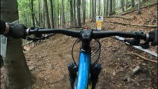
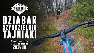
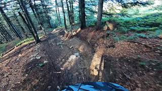
Stroma i kręta trasa w górnej części, z bardzo stromą skalistą ścianką w środkowej i bardzo szybką sekcją na końcu. Zaczyna się na polanie, przy górnej stacji Gondoli (piękny widok!) a kończy na przełęczy „Dylówki”. Wymaga całego asortymentu umiejętności, szczególnie opanowania roweru w stromym terenie.

Access Info

Po wyjściu z górnej stacji gondoli skręć w prawo przy tablicach z mapami. Start przy polanie dawnego stoku "Sahara".

Bike Park

Recent Activity on Trail

Past Week
  • 6 rides
  • 16 miles average
6 Months
  • 15 rides
  • 16 miles avg distance
All
  • 235 rides
  • Last: Jun 16, 2026
c1c2c3c4
January
February
March
April
May
June
July
August
September
October
November
December
update trails status or condition

Dziabar Trail Reports

statusdatedescription
Sep 22, 2025 @ 1:05pm (Europe/Warsaw)
Sep 22, 2025
May 11, 2025 @ 10:49am
May 11, 2025
Nov 10, 2024 @ 9:37am
Nov 10, 2024
Idealnie
Oct 24, 2024 @ 10:07am
Oct 24, 2024
Wejście na ściankę lekko błotniste. Potem już sucho.
Oct 22, 2024 @ 2:33pm
Oct 22, 2024
Trochę liści, poza tym super
more »
Status:
on Sep 22, 2025
Dry
Avg: 4.68 (29 votes)
Your vote: 0

view (5,395)
close
3D
Trail Conditions
  • Unknown
  • Snow Groomed
  • Snow Packed
  • Snow Covered
  • Snow Cover Partial
  • Freeze/thaw Cycle
  • Icy
  • Prevalent Mud
  • Wet
  • Variable
  • Ideal
  • Dry
  • Very Dry
Trail Flow (Ridden Direction)
Trailforks scans users ridelogs to determine the most popular direction each trail is ridden. A good flowing trail network will have most trails flowing in a single direction according to their intension.
The colour categories are based on what percentage of riders are riding a trail in its intended direction.
  • > 96%
  • > 90%
  • > 80%
  • > 70%
  • > 50%
  • < 50%
  • bi-directional trail
  • no data
Trail Last Ridden
Trailforks scans ridelogs to determine the last time a trail was ridden.
  • < 2 days
  • < 1 week
  • < 2 weeks
  • < 1 month
  • < 6 months
  • > 6 months
Trail Ridden Direction
The intended direction a trail should be ridden.
  • Downhill Only
  • Downhill Primary
  • Both Directions
  • Uphill Primary
  • Uphill Only
  • One Direction
Contribute Details
Colors indicate trail is missing specified detail.
  • Description
  • Photos
  • Description & Photos
  • Videos
Trail Popularity ?
Trailforks scans ridelogs to determine which trails are ridden the most in the last 9 months. Trails are compared with nearby trails in the same city region with a possible 25 colour shades. Think of this as a heatmap, more rides = more kinetic energy = warmer colors.
  • most popular
  • popular
  • less popular
  • not popular
ATV/ORV/OHV Filter
Max Vehicle Width
inches
US Cell Coverage
Legend
cell carrier legend

Radar Time
Activity Recordings
Trailforks uses anonymized public activity data. ?
Activity Recordings
Trailforks uses anonymized public activity data. ?
Personal Heatmap
Activity Types
all / none
Options
2
Date range month
Winter Trails
Warning A routing network for winter maps does not exist. Selecting trails using the winter trails layer has been disabled.
Missing Trails
Most Popular
Least Popular
Trails are colored based on popularity. The more popular a trail is, the more red. Less popular trails trend towards green.
Jump Magnitude Heatmap
Heatmap of where riders jump on trails. Zoom in to see individual jumps, click circles to view jump details.
BC Backroad Status

Service Road Atlas is a free to use, community-driven service for viewing and creating reports on the numerous back-country service roads around B.C. and Alberta.

map legend
Slope Aspect
Direction the slope faces
Flat N NE E SE S SW W NW
Trails Deemphasized
Trails are shown in grey.
disable
Only show trails with no bike usage.
Enable
Suggested Layers
Based on selected activity type

    Save the current map location and zoom level as your default home location whenever this page is loaded.

    Save
        Directions to dziabar trailhead (49.760970, 19.000860)

        Photos

        20 more »
        676 |
        Jul 6, 2018 @ 1:43am
        Jul 6, 2018
        462 |
        Sep 18, 2014 @ 12:35pm
        Sep 18, 2014
        345 |
        Oct 22, 2017 @ 11:18pm
        Oct 22, 2017
        43 |
        Aug 22, 2024 @ 10:41am
        Aug 22, 2024

        Videos

        10 more »
        Dziabar
        8:52 | 120 | Nov 9, 2024 , Bielsko-Biała
        Dziabar - czarna trasa na Szyndzielni (Enduro...
        6:03 | 214 | Jun 3, 2024 , Bielsko-Biała
        Szyndzielnia - Dziabar i tajniaki // Bielsko...
        12:27 | 496 | Nov 30, 2020 , Bielsko-Biała
        dziabar top
        0:23 | 282 | Aug 27, 2020 , Bielsko-Biała

        4 Reviews & Comments


        We hope you've been enjoying Trailforks!

        Create a FREE account to view trail comments and much more.

        Frequently Asked Questions About Dziabar

        Where is Dziabar located?
        Dziabar is located in Enduro Trails Bielsko-Biała, Bielsko-Biała, Poland. It is part of the Enduro Trails Bielsko-Biała trail network. The trailhead is located at coordinates 49.76097, 19.00086.
        How hard is Dziabar?
        Dziabar is rated as Black difficulty. The physical rating is Moderate. The average grade is 18.736%.
        What is the elevation gain for Dziabar?
        Dziabar has 28 ft of elevation gain. The trail has 731 ft of elevation descent. The elevation ranges from 2,427 ft to 3,130 ft.
        Is Dziabar a point to point trail?
        Yes, Dziabar is a point to point trail. The direction is Downhill Only. The trail type is singletrack.

        Hit the Trail

        Open in App

        Get this trail on your phone instantly.
        open trail in app

        Download Trail

        Save to wishlist, Garmin & download.
        save the trail

        Find Related Routes

        Find routes and users activities that include this trail.
        find routes for this trail

        You must enter a description before submitting.