This trail is permanently closed/decommissioned
more stats
2.0 miles
Distance
94 ft
Climb
-856 ft
Descent
00:10:33
Avg time
-762 ft
Altitude change
1,471 ft
Altitude min
2,235 ft
Altitude max
2,233 ft
Altitude start
1,473 ft
Altitude end
-7.4%
Grade
-58.6%
Grade max
26.1%
Grade min
1,355 ft
Distance climb
2 miles
Distance down
505 ft
Distance flat
00:10:33
Avg time

Eagle vs Shark Details

  • Activities
    • Mountain Bike
    • E-Bike
  • Riding Area
  • Difficulty Rating
  • Voted Difficulty
    Blue (1 vote)
  • Local Popularity
    65 in Mountain Biking [+]
    • 75 in E-Biking
  • Global Ranking
    #78 in Mountain Biking [+]
    • #1556 in E-Biking
  • Trail Type
    Singletrack
  • Bike Type
    AM, XC
  • Physical Rating
    Moderate
  • Trail Visibility
    Always easy to follow
  • Dogs Allowed
    Yes
  • eBike Allowed
    Yes up to Class 1
  • TTFs on Trail
    Berm
  • Year Opened
    2014

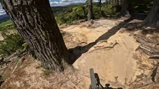
Eagle vs Shark is a beauty. Fast and flowing, mainly downhill, a bit like Corners, a hint of Split Enz and a favourite in no time flat.The trail starts at the top of Tawa Road, one of the highest points in the forest. It winds down a steep slope, facing north, ending on Windy Road (which runs close to parallel to Tarawera Road).
The open areas of this trail can succumb to frost damage, so please avoid when frosty.

Access Info

Top of Tawa Road

Trail Supporters
Local Trail Association

Recent Activity on Trail

Past Week
  • 0 rides
  •  
6 Months
  • 34 rides
  • 22.9 km avg distance
All
  • 1,265 rides
  • Last: Jan 9, 2026
c1c2c3c4
January
February
March
April
May
June
July
August
September
October
November
December
update trails status or condition

Eagle vs Shark Trail Reports

statusdatedescription
May 14, 2026 @ 2:55pm (Pacific/Auckland)
May 13, 2026
reporter Trail is still closed despite the entrance being opened up off skid site, Trail is very overgrown but will be dealt with in next couple of weeks RTT.
Apr 7, 2026 @ 7:46am (Pacific/Auckland)
Apr 6, 2026
Three of us work on EvS yesterday -- cleared several fallen trees and cut back overgrown veg. Did the lower 3/4 of the trail. Needs a rake and...
Apr 1, 2026 @ 8:23am (Pacific/Auckland)
Mar 31, 2026
Basically unrideable. Rutted, massively overgrown, and a number of big trees down. Sad times.
Jan 23, 2026 @ 6:25am (Pacific/Auckland)
Jan 22, 2026
Small tree down across trail, can ride under. In forest section just after an uphill. Lower section of eagle vs shark can be ridden on weekends...
Jan 8, 2026 @ 8:27pm (Pacific/Auckland)
Jan 7, 2026
more »
Status:
on May 14, 2026
Avg: 4.74 (73 votes)
Your vote: 0

view (9,255)
close
3D
Trail Conditions
  • Unknown
  • Snow Groomed
  • Snow Packed
  • Snow Covered
  • Snow Cover Partial
  • Freeze/thaw Cycle
  • Icy
  • Prevalent Mud
  • Wet
  • Variable
  • Ideal
  • Dry
  • Very Dry
Trail Flow (Ridden Direction)
Trailforks scans users ridelogs to determine the most popular direction each trail is ridden. A good flowing trail network will have most trails flowing in a single direction according to their intension.
The colour categories are based on what percentage of riders are riding a trail in its intended direction.
  • > 96%
  • > 90%
  • > 80%
  • > 70%
  • > 50%
  • < 50%
  • bi-directional trail
  • no data
Trail Last Ridden
Trailforks scans ridelogs to determine the last time a trail was ridden.
  • < 2 days
  • < 1 week
  • < 2 weeks
  • < 1 month
  • < 6 months
  • > 6 months
Trail Ridden Direction
The intended direction a trail should be ridden.
  • Downhill Only
  • Downhill Primary
  • Both Directions
  • Uphill Primary
  • Uphill Only
  • One Direction
Contribute Details
Colors indicate trail is missing specified detail.
  • Description
  • Photos
  • Description & Photos
  • Videos
Trail Popularity ?
Trailforks scans ridelogs to determine which trails are ridden the most in the last 9 months. Trails are compared with nearby trails in the same city region with a possible 25 colour shades. Think of this as a heatmap, more rides = more kinetic energy = warmer colors.
  • most popular
  • popular
  • less popular
  • not popular
ATV/ORV/OHV Filter
Max Vehicle Width
inches
US Cell Coverage
Legend
cell carrier legend

Radar Time
Activity Recordings
Trailforks uses anonymized public activity data. ?
Activity Recordings
Trailforks uses anonymized public activity data. ?
Personal Heatmap
Activity Types
all / none
Options
2
Date range month
Winter Trails
Warning A routing network for winter maps does not exist. Selecting trails using the winter trails layer has been disabled.
Missing Trails
Most Popular
Least Popular
Trails are colored based on popularity. The more popular a trail is, the more red. Less popular trails trend towards green.
Jump Magnitude Heatmap
Heatmap of where riders jump on trails. Zoom in to see individual jumps, click circles to view jump details.
BC Backroad Status

Service Road Atlas is a free to use, community-driven service for viewing and creating reports on the numerous back-country service roads around B.C. and Alberta.

map legend
Slope Aspect
Direction the slope faces
Flat N NE E SE S SW W NW
Trails Deemphasized
Trails are shown in grey.
disable
Only show trails with no bike usage.
Enable
Suggested Layers
Based on selected activity type

    Save the current map location and zoom level as your default home location whenever this page is loaded.

    Save
        Directions to eagle-vs-shark trailhead (-38.177520, 176.310310)

        Photos

        89 more »
        98 |
        Mar 26, 2025 @ 1:25pm
        Mar 26, 2025
        88 |
        Mar 26, 2025 @ 1:25pm
        Mar 26, 2025
        62 |
        Mar 26, 2025 @ 1:26pm
        Mar 26, 2025
        80 |
        Mar 26, 2025 @ 1:26pm
        Mar 26, 2025

        Videos

        31 more »
        youtuber Redwoods Rampage  [Ep#86]
        16:25 | 733 | Nov 14, 2019 , Rotorua
        youtuber Eagle vs Shark 2.0 - The Legend Returns!   [Ep#74]
        8:25 | 1330 | Mar 25, 2019 , Rotorua
        youtuber Eagle vs Shark @ Whakarewarewa Forest. Rotorua
        2:35 | 72 | Jan 5, 2026 , Rotorua
        youtuber Eagle v Shark @ Whakarewarewa Forest. Rotorua
        7:31 | 358 | Dec 4, 2023 , Rotorua

        Routes with this trail

        18 miles 3,188 ft 13 Loop
        Lake ride, taking in Blue & Green Lake but adding in a bit of great flow trail before and the ever popular...
        16 miles 3,368 ft 6 Loop
        RMTBC E-Bike Social Ride Short 02/11/24
        8 miles 1,886 ft 6 Loop
        Short and sharp loop that takes in a couple of the very best trails the Rotorua has to offer, without...

        16 Reviews & Comments


        We hope you've been enjoying Trailforks!

        Create a FREE account to view trail comments and much more.

        • By Demo4lifeTF Pro & contributors
        • #20149 - 21,545 views

        Frequently Asked Questions About Eagle vs Shark

        Where is Eagle vs Shark located?
        Eagle vs Shark is located in Whakarewarewa Forest, Rotorua, New Zealand. It is part of the Whakarewarewa Forest trail network. The trailhead is located at coordinates -38.17752, 176.31031.
        How hard is Eagle vs Shark?
        Eagle vs Shark is rated as Blue difficulty. The physical rating is Moderate. The average grade is 7.4%.
        What is the elevation gain for Eagle vs Shark?
        Eagle vs Shark has 94 ft of elevation gain. The trail has 856 ft of elevation descent. The elevation ranges from 1,471 ft to 2,235 ft.
        How long is Eagle vs Shark?
        Eagle vs Shark is 2.0 miles long. The trail type is singletrack.

        Hit the Trail

        Open in App

        Get this trail on your phone instantly.
        open trail in app

        Download Trail

        Save to wishlist, Garmin & download.
        save the trail

        Find Related Routes

        Find routes and users activities that include this trail.
        find routes for this trail

        You must enter a description before submitting.