more stats
2,100 ft
Distance
75 ft
Climb
-3 ft
Descent
00:06:21
Avg time
72 ft
Altitude change
1,670 ft
Altitude min
1,742 ft
Altitude max
1,671 ft
Altitude start
1,742 ft
Altitude end
3.4%
Grade
-8.9%
Grade max
12.1%
Grade min
1,053 ft
Distance climb
203 ft
Distance down
751 ft
Distance flat
00:06:21
Avg time

Earn It Details

  • Activities
    • Mountain Bike
    • E-Bike
  • Riding Area
    WinMan Trails
    Manitowish Waters, Wisconsin
  • Difficulty Rating
  • Local Popularity
    100 in Mountain Biking [+]
    • 100 in E-Biking
  • Global Ranking
    #931 in Mountain Biking
  • Trail Type
    Singletrack
  • Direction
    One Direction
    Popular Direction Shown
  • Climb Difficulty
    Blue
  • Physical Rating
    Moderate
  • Trail Visibility
    Always easy to follow
  • Dogs Allowed
    Yes
  • eBike Allowed
    Yes up to Class 1
  • Year Opened
    2021
  • Land Owner
    WinMan Trails

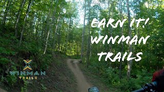
Earn it is a climbing trail with a couple of jumps thrown in to keep things fun. It takes riders to the central hub of the trail system allowing them to ride High Five, Send It, Roller Creek or the second portion of WinMan One

Local Trail Association

Recent Activity on Trail

Past Week
  • 6 rides
  • 22 miles average
6 Months
  • 45 rides
  • 13 miles avg distance
All
  • 488 rides
  • Last: Jun 20, 2026
c1c2c3c4
January
February
March
April
May
June
July
August
September
October
November
December
update trails status or condition

Earn It Trail Reports

Status:
on May 27, 2026
Ideal
Avg: 4.21 (3 votes)
Your vote: 0

view (5,464)
close
3D
Trail Conditions
  • Unknown
  • Snow Groomed
  • Snow Packed
  • Snow Covered
  • Snow Cover Partial
  • Freeze/thaw Cycle
  • Icy
  • Prevalent Mud
  • Wet
  • Variable
  • Ideal
  • Dry
  • Very Dry
Trail Flow (Ridden Direction)
Trailforks scans users ridelogs to determine the most popular direction each trail is ridden. A good flowing trail network will have most trails flowing in a single direction according to their intension.
The colour categories are based on what percentage of riders are riding a trail in its intended direction.
  • > 96%
  • > 90%
  • > 80%
  • > 70%
  • > 50%
  • < 50%
  • bi-directional trail
  • no data
Trail Last Ridden
Trailforks scans ridelogs to determine the last time a trail was ridden.
  • < 2 days
  • < 1 week
  • < 2 weeks
  • < 1 month
  • < 6 months
  • > 6 months
Trail Ridden Direction
The intended direction a trail should be ridden.
  • Downhill Only
  • Downhill Primary
  • Both Directions
  • Uphill Primary
  • Uphill Only
  • One Direction
Contribute Details
Colors indicate trail is missing specified detail.
  • Description
  • Photos
  • Description & Photos
  • Videos
Trail Popularity ?
Trailforks scans ridelogs to determine which trails are ridden the most in the last 9 months. Trails are compared with nearby trails in the same city region with a possible 25 colour shades. Think of this as a heatmap, more rides = more kinetic energy = warmer colors.
  • most popular
  • popular
  • less popular
  • not popular
ATV/ORV/OHV Filter
Max Vehicle Width
inches
US Cell Coverage
Legend
cell carrier legend

Radar Time
Activity Recordings
Trailforks uses anonymized public activity data. ?
Activity Recordings
Trailforks uses anonymized public activity data. ?
Personal Heatmap
Activity Types
all / none
Options
2
Date range month
Winter Trails
Warning A routing network for winter maps does not exist. Selecting trails using the winter trails layer has been disabled.
Missing Trails
Most Popular
Least Popular
Trails are colored based on popularity. The more popular a trail is, the more red. Less popular trails trend towards green.
Jump Magnitude Heatmap
Heatmap of where riders jump on trails. Zoom in to see individual jumps, click circles to view jump details.
BC Backroad Status

Service Road Atlas is a free to use, community-driven service for viewing and creating reports on the numerous back-country service roads around B.C. and Alberta.

map legend
Slope Aspect
Direction the slope faces
Flat N NE E SE S SW W NW
Trails Deemphasized
Trails are shown in grey.
disable
Only show trails with no bike usage.
Enable
Suggested Layers
Based on selected activity type

    Save the current map location and zoom level as your default home location whenever this page is loaded.

    Save
        Directions to earn-it trailhead (46.187360, -89.884480)

        Photos

        No photos have been added for Earn It yet, add a photo.

        Videos

        1 more »
        Earn It, WinMan Trails
        3:20 | 169 | Sep 2, 2022 , Manitowish Waters

        Routes with this trail

        5 miles 314 ft 6 Loop
        A tour of some of the best rocky tech, jumps, bridges and drops that WinMan has to offer.
        8 miles 510 ft 8 Loop
        Head out to the back side of WinMan for a great mix of jumps, berms, and rolling fun singletrack.

        Reviews / Comments

        No reviews yet, be the first to write a review or ask a question.
        Use trail reports to comment on trail conditions.


        We hope you've been enjoying Trailforks!

        Create a FREE account to view trail comments and much more.

        • By alfotschTF Pro Winman & contributors
        • #446266 - 491 views

        Frequently Asked Questions About Earn It

        Where is Earn It located?
        Earn It is located in WinMan Trails, Manitowish Waters, Wisconsin, United States. It is part of the WinMan Trails trail network. The trailhead is located at coordinates 46.18736, -89.88448.
        How hard is Earn It?
        Earn It is rated as Blue difficulty. The physical rating is Moderate. The average grade is 3.4%. The climb difficulty is rated Blue.
        What is the elevation gain for Earn It?
        Earn It has 75 ft of elevation gain. The trail has 3 ft of elevation descent. The elevation ranges from 1,670 ft to 1,742 ft.
        Is Earn It a point to point trail?
        Yes, Earn It is a point to point trail. The direction is One Direction. The trail type is singletrack.

        Hit the Trail

        Open in App

        Get this trail on your phone instantly.
        open trail in app

        Download Trail

        Save to wishlist, Garmin & download.
        save the trail

        Find Related Routes

        Find routes and users activities that include this trail.
        find routes for this trail

        You must enter a description before submitting.