more stats
3.0 miles
Distance
151 ft
Climb
-529 ft
Descent
00:28:03
Avg time
-378 ft
Altitude change
4,534 ft
Altitude min
4,983 ft
Altitude max
4,911 ft
Altitude start
4,534 ft
Altitude end
-2.4%
Grade
-26.7%
Grade max
14.6%
Grade min
4,285 ft
Distance climb
2 miles
Distance down
1,644 ft
Distance flat
00:28:03
Avg time

EKG Details

  • Activities
    • Mountain Bike
    • E-Bike
    • Winter Fat Bike
    • Hike
    • Trail Running
  • Riding Area
    Canmore Nordic Centre
    Canmore, Alberta
  • Difficulty Rating
  • Voted Difficulty
    Blue (1 vote)
  • Local Popularity
    90 in Mountain Biking [+]
    • 80 in E-Biking
    • 90 in Trail Running
    • 60 in Hiking
  • Global Ranking
    #1159 in Mountain Biking [+]
    • #658 in Trail Running
    • #65769 in Hiking
  • Trail Type
    Singletrack
  • Bike Type
    AM, XC, Fat
  • Direction
    Both Directions
    Popular Direction Shown
  • Climb Difficulty
    Blue
  • Physical Rating
    Moderate
  • Dogs Allowed
    Yes
  • eBike Allowed
  • TTFs on Trail
    Berm, Bridge
  • Land Owner
    Alberta Parks

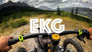
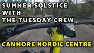
Probably the most-used trail at the Canmore Nordic Centre, and part of many race routes. It's 99% singletrack through forest and meadows, with many climbs and descents. Rooty sections, rocky sections and smooth sections - it has everything

Access Info

Most riders start on EKG East and keep rolling on EKG in a clockwise direction from the stadium area, but it can be done in either direction.

Recent Activity on Trail

Past Week
  • 7 rides
  • 9 miles average
6 Months
  • 99 rides
  • 9 miles avg distance
All
  • 1,136 rides
  • Last: Jun 24, 2026
c1c2c3c4
January
February
March
April
May
June
July
August
September
October
November
December
update trails status or condition

EKG Trail Reports

statusdatedescription
May 11, 2026 @ 10:31am (America/Edmonton)
May 11, 2026
Oct 13, 2025 @ 10:30am (America/Creston)
Oct 13, 2025
Tree down at the junction of Alberten and EKG
Sep 29, 2025 @ 10:03am (America/Creston)
Sep 29, 2025
Occasional loose cobble on the trail below the Odyssey junction. Keep your eyes peeled!
Sep 18, 2025 @ 6:10pm (America/Creston)
Sep 18, 2025
Aug 19, 2025 @ 3:46pm
Aug 19, 2025
A few very dry spots that are a bit slippery, but otherwise rides great!
more »
Status:
on May 11, 2026
Ideal
Avg: 4.47 (33 votes)
Your vote: 0

view (6,204)
close
3D
Trail Conditions
  • Unknown
  • Snow Groomed
  • Snow Packed
  • Snow Covered
  • Snow Cover Partial
  • Freeze/thaw Cycle
  • Icy
  • Prevalent Mud
  • Wet
  • Variable
  • Ideal
  • Dry
  • Very Dry
Trail Flow (Ridden Direction)
Trailforks scans users ridelogs to determine the most popular direction each trail is ridden. A good flowing trail network will have most trails flowing in a single direction according to their intension.
The colour categories are based on what percentage of riders are riding a trail in its intended direction.
  • > 96%
  • > 90%
  • > 80%
  • > 70%
  • > 50%
  • < 50%
  • bi-directional trail
  • no data
Trail Last Ridden
Trailforks scans ridelogs to determine the last time a trail was ridden.
  • < 2 days
  • < 1 week
  • < 2 weeks
  • < 1 month
  • < 6 months
  • > 6 months
Trail Ridden Direction
The intended direction a trail should be ridden.
  • Downhill Only
  • Downhill Primary
  • Both Directions
  • Uphill Primary
  • Uphill Only
  • One Direction
Contribute Details
Colors indicate trail is missing specified detail.
  • Description
  • Photos
  • Description & Photos
  • Videos
Trail Popularity ?
Trailforks scans ridelogs to determine which trails are ridden the most in the last 9 months. Trails are compared with nearby trails in the same city region with a possible 25 colour shades. Think of this as a heatmap, more rides = more kinetic energy = warmer colors.
  • most popular
  • popular
  • less popular
  • not popular
ATV/ORV/OHV Filter
Max Vehicle Width
inches
US Cell Coverage
Legend
cell carrier legend

Radar Time
Activity Recordings
Trailforks uses anonymized public activity data. ?
Activity Recordings
Trailforks uses anonymized public activity data. ?
Personal Heatmap
Activity Types
all / none
Options
2
Date range month
Winter Trails
Warning A routing network for winter maps does not exist. Selecting trails using the winter trails layer has been disabled.
Missing Trails
Most Popular
Least Popular
Trails are colored based on popularity. The more popular a trail is, the more red. Less popular trails trend towards green.
Jump Magnitude Heatmap
Heatmap of where riders jump on trails. Zoom in to see individual jumps, click circles to view jump details.
BC Backroad Status

Service Road Atlas is a free to use, community-driven service for viewing and creating reports on the numerous back-country service roads around B.C. and Alberta.

map legend
Slope Aspect
Direction the slope faces
Flat N NE E SE S SW W NW
Trails Deemphasized
Trails are shown in grey.
disable
Only show trails with no bike usage.
Enable
Suggested Layers
Based on selected activity type

    Save the current map location and zoom level as your default home location whenever this page is loaded.

    Save
        Directions to ekg-10027 trailhead (51.095370, -115.394470)

        Photos

        45 more »
        156 |
        Aug 22, 2023 @ 10:23am
        Aug 22, 2023
        149 |
        Aug 22, 2023 @ 10:23am
        Aug 22, 2023
        148 |
        Aug 22, 2023 @ 10:23am
        Aug 22, 2023
        123 |
        Apr 27, 2023 @ 9:33pm
        Apr 27, 2023

        Videos

        8 more »
        youtuber Alberta Trip(Part 3) - Visiting Banff &...
        11:15 | 1175 | Oct 15, 2018 , Canmore
        Christian Bagg rides EKG in Canmore
        10:01 | 1086 | Jan 13, 2021 , Canmore
        Canmore Nordic Centre // EKG - Odyssey - Coal...
        7:14 | 1662 | Jun 27, 2019 , Canmore
        GoPro: Full Canmore Mountain Biking May 24 2015
        1216 | May 27, 2015 , Canmore

        Routes with this trail

        4.0 5 miles 650 ft 3 Loop
        ORANGE LOOP: 7.5 km (mainly single track) • The CNC’s most popular trail. • Best ridden clockwise...
        5.0 8 miles 1,030 ft 9
        Have fun exploring the awesome single track up at the Nordic Center! Mostly climbing to start, with some...
        3.4 6 miles 719 ft 4 Loop
        Winter single track fat bike loop (2015-2016) as designated by Canmore Nordic Centre. When crossing XC ski...

        9 Reviews & Comments


        We hope you've been enjoying Trailforks!

        Create a FREE account to view trail comments and much more.

        • By megandTF Pro & contributors
        • #10027 - 18,072 views

        Frequently Asked Questions About EKG

        Where is EKG located?
        EKG is located in Canmore Nordic Centre, Canmore, Alberta, Canada. It is part of the Canmore Nordic Centre trail network. The trailhead is located at coordinates 51.09537, -115.39447.
        How hard is EKG?
        EKG is rated as Blue difficulty. The physical rating is Moderate. The average grade is 2.4%. The climb difficulty is rated Blue.
        What is the elevation gain for EKG?
        EKG has 151 ft of elevation gain. The trail has 529 ft of elevation descent. The elevation ranges from 4,534 ft to 4,983 ft.
        Is EKG a point to point trail?
        EKG is not a point to point trail. The direction is Both Directions. The trail type is singletrack.

        Hit the Trail

        Open in App

        Get this trail on your phone instantly.
        open trail in app

        Download Trail

        Save to wishlist, Garmin & download.
        save the trail

        Find Related Routes

        Find routes and users activities that include this trail.
        find routes for this trail

        You must enter a description before submitting.