more stats
1,545 ft
Distance
-189 ft
Descent
00:01:55
Avg time
-189 ft
Altitude change
857 ft
Altitude min
1,045 ft
Altitude max
1,045 ft
Altitude start
856 ft
Altitude end
-12.2%
Grade
-25%
Grade max
-2.1%
Grade min
1,545 ft
Distance down
00:01:55
Avg time

Electric Lettuce Details

  • Activities
    • Mountain Bike
    • Hike
    • Trail Running
  • Riding Area
    Vedder Mountain
    Chilliwack, British Columbia
  • Difficulty Rating
  • Voted Difficulty
    Blue (2 votes)
  • Local Popularity
    100 in Mountain Biking [+]
    • 80 in Trail Running
    • 80 in Hiking
  • Global Ranking
    #12120 in Mountain Biking [+]
    • #37902 in Trail Running
    • #65475 in Hiking
  • Trail Type
    Singletrack
  • Bike Type
    DH, AM
  • Direction
    Downhill Primary
    Popular Direction Shown
  • Dogs Allowed
    Yes
  • TTFs on Trail
    A-Frame, Jump
  • Land Owner
    RSTBC

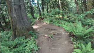
Generally a flowy trail. The top is fast with a couple optional jumps. The middle section has several wood features. The lower section of the trail flattens out, and has the largest skinny on the mountain (optional). The trail exits right above Allan's Trail and Femur

Trail Supporters
  • past supporters

Local Trail Association
Traditionally Indigenous Territory

Recent Activity on Trail

Past Week
  • 10 rides
  • 7 miles average
6 Months
  • 104 rides
  • 8 miles avg distance
All
  • 903 rides
  • Last: Jun 17, 2026
c1c2c3c4
January
February
March
April
May
June
July
August
September
October
November
December
Status:
on Jun 11, 2026
Avg: 4.51 (45 votes)
Your vote: 0

view (6,392)
close
3D
Trail Conditions
  • Unknown
  • Snow Groomed
  • Snow Packed
  • Snow Covered
  • Snow Cover Partial
  • Freeze/thaw Cycle
  • Icy
  • Prevalent Mud
  • Wet
  • Variable
  • Ideal
  • Dry
  • Very Dry
Trail Flow (Ridden Direction)
Trailforks scans users ridelogs to determine the most popular direction each trail is ridden. A good flowing trail network will have most trails flowing in a single direction according to their intension.
The colour categories are based on what percentage of riders are riding a trail in its intended direction.
  • > 96%
  • > 90%
  • > 80%
  • > 70%
  • > 50%
  • < 50%
  • bi-directional trail
  • no data
Trail Last Ridden
Trailforks scans ridelogs to determine the last time a trail was ridden.
  • < 2 days
  • < 1 week
  • < 2 weeks
  • < 1 month
  • < 6 months
  • > 6 months
Trail Ridden Direction
The intended direction a trail should be ridden.
  • Downhill Only
  • Downhill Primary
  • Both Directions
  • Uphill Primary
  • Uphill Only
  • One Direction
Contribute Details
Colors indicate trail is missing specified detail.
  • Description
  • Photos
  • Description & Photos
  • Videos
Trail Popularity ?
Trailforks scans ridelogs to determine which trails are ridden the most in the last 9 months. Trails are compared with nearby trails in the same city region with a possible 25 colour shades. Think of this as a heatmap, more rides = more kinetic energy = warmer colors.
  • most popular
  • popular
  • less popular
  • not popular
ATV/ORV/OHV Filter
Max Vehicle Width
inches
US Cell Coverage
Legend
cell carrier legend

Radar Time
Activity Recordings
Trailforks uses anonymized public activity data. ?
Activity Recordings
Trailforks uses anonymized public activity data. ?
Personal Heatmap
Activity Types
all / none
Options
2
Date range month
Winter Trails
Warning A routing network for winter maps does not exist. Selecting trails using the winter trails layer has been disabled.
Missing Trails
Most Popular
Least Popular
Trails are colored based on popularity. The more popular a trail is, the more red. Less popular trails trend towards green.
Jump Magnitude Heatmap
Heatmap of where riders jump on trails. Zoom in to see individual jumps, click circles to view jump details.
BC Backroad Status

Service Road Atlas is a free to use, community-driven service for viewing and creating reports on the numerous back-country service roads around B.C. and Alberta.

map legend
Slope Aspect
Direction the slope faces
Flat N NE E SE S SW W NW
Trails Deemphasized
Trails are shown in grey.
disable
Only show trails with no bike usage.
Enable
Suggested Layers
Based on selected activity type

    Save the current map location and zoom level as your default home location whenever this page is loaded.

    Save
        Directions to electric-lettuce trailhead (49.076930, -121.997050)

        Photos

        59 more »
        703 |
        Jun 9, 2017 @ 8:04am
        Jun 9, 2017
        466 |
        May 11, 2017 @ 9:02am
        May 11, 2017
        445 |
        Mar 22, 2013 @ 3:51pm
        Mar 22, 2013
        82 |
        Jun 5, 2023 @ 8:16pm
        Jun 5, 2023

        Videos

        7 more »
        Electric Lettuce  - Chilliwack, BC - MTB Trail...
        0:55 | 169 | Dec 30, 2024 , Chilliwack
        Electric Lettuce Vedder Mountain
        2:40 | 68 | Dec 29, 2024 , Chilliwack
        youtuber DO NOT BUY THESE!
        7:50 | 105 | Mar 6, 2024 , Chilliwack
        Electric Lettuce to Mango Mango Vedder Mountain
        2:51 | 214 | Aug 7, 2023 , Chilliwack

        Routes with this trail

        3.0 3 miles 831 ft 9 Loop
        Good climb on the awesome new , followed by flowy downhill fun. TTF's include bridges (can be bypassed)...
        3.0 6 miles 1,503 ft 14
        XC(ish) for BC loop. Long easy climb to warmup. mix of flow and tech trails that you around the top of ...
        3.5 6 miles 1,690 ft 37
        Inaugural Chilliwack Toonie Tuesday Ride. Pre-race competitive group riding, the goal is to push your own...

        1 Review & Comments


        We hope you've been enjoying Trailforks!

        Create a FREE account to view trail comments and much more.

        • By BCpovTF Pro & contributors
        • #949 - 10,465 views

        Frequently Asked Questions About Electric Lettuce

        Where is Electric Lettuce located?
        Electric Lettuce is located in Vedder Mountain, Chilliwack, British Columbia, Canada. It is part of the Vedder Mountain trail network. The trailhead is located at coordinates 49.07693, -121.99705.
        How hard is Electric Lettuce?
        Electric Lettuce is rated as Blue difficulty. The average grade is 12.2%.
        What is the elevation gain for Electric Lettuce?
        The trail has 189 ft of elevation descent. The elevation ranges from 857 ft to 1,045 ft.
        Is Electric Lettuce a point to point trail?
        Electric Lettuce is not a point to point trail. The direction is Downhill Primary. The trail type is singletrack.

        Hit the Trail

        Open in App

        Get this trail on your phone instantly.
        open trail in app

        Download Trail

        Save to wishlist, Garmin & download.
        save the trail

        Find Related Routes

        Find routes and users activities that include this trail.
        find routes for this trail

        You must enter a description before submitting.