more stats
6.6 miles
Distance
2,095 ft
Climb
-469 ft
Descent
02:46:59
Avg time
1,623 ft
Altitude change
3,224 ft
Altitude min
5,229 ft
Altitude max
3,224 ft
Altitude start
4,849 ft
Altitude end
4.6%
Grade
-19.8%
Grade max
32.9%
Grade min
5 miles
Distance climb
2 miles
Distance down
344 ft
Distance flat
02:46:59
Avg time

Elfin Lakes Details

  • Activities
    • Mountain Bike
    • E-Bike
    • Gravel Bike
    • Hike
    • Trail Running
    • Snowshoe
    • Backcountry Ski
  • Riding Area
    Elfin Lakes / Red Heather / Paul Ridge
    Squamish, British Columbia
  • AKA
    Diamond Head
  • Difficulty Rating
  • Voted Difficulty
    Blue (2 votes)
  • Local Popularity
    65 in Mountain Biking [+]
    • 80 in E-Biking
    • 50 in Trail Running
    • 95 in Hiking
    • 95 in Snowshoeing
    • 5 in Backcountry Skiing
  • Global Ranking
    #44517 in Mountain Biking [+]
    • #2463 in E-Biking
    • #61111 in Trail Running
    • #372 in Hiking
    • #13 in Snowshoeing
    • #589 in Backcountry Skiing
  • Hiking SAC Scale
    T1 Hiking
  • Trail Type
    Doubletrack
  • Snow Grooming
    Backcountry
  • Bike Type
    XC, Gravel
  • Direction
    Both Directions
  • Climb Difficulty
    Blue
  • Physical Rating
    Moderate
  • Trail Visibility
    Always easy to follow
  • Season
    bike Jun-Nov ski Nov-May
  • Family Friendly
    Yes
  • eBike Allowed
    Yes up to Class 1
  • Ride in Rain
    Yes
  • Land Owner

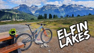
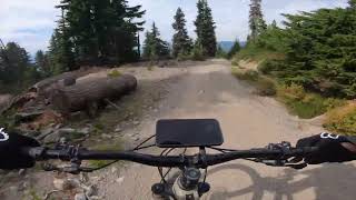
This is the Elfin Lakes trail that is used by hikers and bikers in summer and skiers and snowshoers in the winter. It starts at 950m elevation and climbs to the ridge high point at 1,600m and then down to Elfin Lakes at 1,500m. The trail is 21km return. However, due to the rocky surface, this ride feels like a solid 30km. Bring the fattest tires you have and run them at low PSI for maximum enjoyment

There is a waterfall partway up and a few other sources of water as long as it has not been dry for too long.

Please note, cycling is prohibited around the lakes. Cycling is only permitted on the trail to the campground.

Access Info

Go up to Diamond Head parking lot.

Disclaimer

Warning: It's prohibited under the Parks Act to harvest anything in the park, including blueberries. Blueberries are an important food source for bear leading into hibernation.

Trail Supporters

Recent Activity on Trail

Past Week
  • 1 rides
  • 15.5 km average
6 Months
  • 3 rides
  • 14.7 km avg distance
All
  • 212 rides
  • Last: Jun 20, 2026
c1c2c3c4
January
February
March
April
May
June
July
August
September
October
November
December
update trails status or condition

Elfin Lakes Trail Reports

statusdatedescription
Jun 15, 2026 @ 12:08pm (America/Vancouver)
Jun 15, 2026
Completely snow covered after the 5km to elfin lakes sign post
Oct 27, 2025 @ 11:09pm (America/Vancouver)
Oct 27, 2025
Snow line between 1100-1200
Oct 12, 2025 @ 10:51pm (America/Vancouver)
Oct 12, 2025
First snowfall of the season today, down to ~1200m
Aug 3, 2025 @ 9:52am
Aug 3, 2025
Looks like the trail has had a fair bit of work since last summer. It's much smoother now. Thanks to BC Parks!
Jul 28, 2025 @ 10:40am
Jul 28, 2025
Now very dry. Not a speck of snow anywhere. Amazing views. It might be a 10k ride from the parking lot but don’t expect to smash it out loud...
more »
Status:
on Jun 15, 2026
Snow Cover Partial
Avg: 3.89 (21 votes)
Your vote: 0

view (2,183)
close
3D
Trail Conditions
  • Unknown
  • Snow Groomed
  • Snow Packed
  • Snow Covered
  • Snow Cover Partial
  • Freeze/thaw Cycle
  • Icy
  • Prevalent Mud
  • Wet
  • Variable
  • Ideal
  • Dry
  • Very Dry
Trail Flow (Ridden Direction)
Trailforks scans users ridelogs to determine the most popular direction each trail is ridden. A good flowing trail network will have most trails flowing in a single direction according to their intension.
The colour categories are based on what percentage of riders are riding a trail in its intended direction.
  • > 96%
  • > 90%
  • > 80%
  • > 70%
  • > 50%
  • < 50%
  • bi-directional trail
  • no data
Trail Last Ridden
Trailforks scans ridelogs to determine the last time a trail was ridden.
  • < 2 days
  • < 1 week
  • < 2 weeks
  • < 1 month
  • < 6 months
  • > 6 months
Trail Ridden Direction
The intended direction a trail should be ridden.
  • Downhill Only
  • Downhill Primary
  • Both Directions
  • Uphill Primary
  • Uphill Only
  • One Direction
Contribute Details
Colors indicate trail is missing specified detail.
  • Description
  • Photos
  • Description & Photos
  • Videos
Trail Popularity ?
Trailforks scans ridelogs to determine which trails are ridden the most in the last 9 months. Trails are compared with nearby trails in the same city region with a possible 25 colour shades. Think of this as a heatmap, more rides = more kinetic energy = warmer colors.
  • most popular
  • popular
  • less popular
  • not popular
ATV/ORV/OHV Filter
Max Vehicle Width
inches
US Cell Coverage
Legend
cell carrier legend

Radar Time
Activity Recordings
Trailforks uses anonymized public activity data. ?
Activity Recordings
Trailforks uses anonymized public activity data. ?
Personal Heatmap
Activity Types
all / none
Options
2
Date range month
Winter Trails
Warning A routing network for winter maps does not exist. Selecting trails using the winter trails layer has been disabled.
Missing Trails
Most Popular
Least Popular
Trails are colored based on popularity. The more popular a trail is, the more red. Less popular trails trend towards green.
Jump Magnitude Heatmap
Heatmap of where riders jump on trails. Zoom in to see individual jumps, click circles to view jump details.
BC Backroad Status

Service Road Atlas is a free to use, community-driven service for viewing and creating reports on the numerous back-country service roads around B.C. and Alberta.

map legend
Slope Aspect
Direction the slope faces
Flat N NE E SE S SW W NW
Trails Deemphasized
Trails are shown in grey.
disable
Only show trails with no bike usage.
Enable
Suggested Layers
Based on selected activity type

    Save the current map location and zoom level as your default home location whenever this page is loaded.

    Save
        Directions to elfin-lakes trailhead (49.750160, -123.053020)

        Photos

        170 more »
        871 |
        Feb 20, 2019 @ 4:56pm
        Feb 20, 2019
        59 |
        Jul 6, 2025 @ 8:10pm
        Jul 6, 2025
        84 |
        Jul 6, 2025 @ 8:10pm
        Jul 6, 2025
        66 |
        Jul 6, 2025 @ 8:10pm
        Jul 6, 2025

        Videos

        8 more »
        youtuber The Squamish Alpine is Magical
        23:14 | 1614 | Dec 12, 2021 , Squamish
        youtuber Elfin Lakes Tour by E-Bike, Yes it's Legal!
        20:34 | 692 | Aug 3, 2023 , Squamish
        youtuber Elfin Lakes, Squamish Trail On A Mountain Bike...
        10:59 | 2748 | Oct 16, 2017 , Squamish
        Elfin Lakes Trail - Squamish BC
        4:15 | 290 | Sep 16, 2023 , Squamish

        Trail Lists

        • bms
          28 trails

        Routes with this trail

        3.2 13 miles 2,559 ft 1 Out & Back
        This is not your typical Squamish mountain bike ride. In fact, the entire ride is on double track and old...
        5.0 26 miles 5,727 ft 41 Loop
        The longest day of the year is a good enough excuse to go for the longest ride! This route will take you...
        2.0 28 miles 6,180 ft 6 Out & Back
        Climbing route to , followed by descent on Meadow of the Grizzly a

        17 Reviews & Comments


        We hope you've been enjoying Trailforks!

        Create a FREE account to view trail comments and much more.

        • By spinorama & contributors
        • #13359 - 42,328 views

        Frequently Asked Questions About Elfin Lakes

        Where is Elfin Lakes located?
        Elfin Lakes is located in Elfin Lakes / Red Heather / Paul Ridge, Squamish, British Columbia, Canada. It is part of the Elfin Lakes / Red Heather / Paul Ridge trail network. The trailhead is located at coordinates 49.75016, -123.05302.
        How hard is Elfin Lakes?
        Elfin Lakes is rated as Green difficulty. The physical rating is Moderate. The average grade is 4.6%. The climb difficulty is rated Blue.
        What is the elevation gain for Elfin Lakes?
        Elfin Lakes has 2,095 ft of elevation gain. The trail has 469 ft of elevation descent. The elevation ranges from 3,224 ft to 5,229 ft.
        Is Elfin Lakes a point to point trail?
        Elfin Lakes is not a point to point trail. The direction is Both Directions. The trail type is doubletrack.

        Hit the Trail

        Open in App

        Get this trail on your phone instantly.
        open trail in app

        Download Trail

        Save to wishlist, Garmin & download.
        save the trail

        Find Related Routes

        Find routes and users activities that include this trail.
        find routes for this trail

        You must enter a description before submitting.