more stats
4.3 miles
Distance
1,858 ft
Climb
-44 ft
Descent
01:27:28
Avg time
1,814 ft
Altitude change
7,108 ft
Altitude min
8,937 ft
Altitude max
7,108 ft
Altitude start
8,924 ft
Altitude end
7.9%
Grade
-13.6%
Grade max
48.8%
Grade min
4 miles
Distance climb
1,007 ft
Distance down
574 ft
Distance flat
01:27:28
Avg time

Emerald Lake Details

  • Activities
    • Mountain Bike
    • E-Bike
    • Horse
    • Hike
    • Trail Running
  • Riding Area
    Northern Gallatin Range
    Bozeman, Montana
  • Ref Number
    #434
  • Difficulty Rating
  • Voted Difficulty
    Blue (1 vote)
  • Local Popularity
    75 in Mountain Biking [+]
    • 75 in E-Biking
    • 70 in Trail Running
    • 95 in Hiking
    • 5 in Horseback
  • Global Ranking
    #64662 in Mountain Biking [+]
    • #74108 in Trail Running
    • #23588 in Hiking
  • Trail Type
    Singletrack
  • Bike Type
    AM, Fat
  • Direction
    Both Directions
  • Climb Difficulty
    Black Diamond
  • Physical Rating
    Hard
  • Season
    June-September
  • Dogs Allowed
    Yes
  • eBike Allowed
    Yes up to Class 1
  • TTFs on Trail
    Bridge
  • Land Owner
    Custer Gallatin National Forest

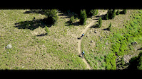
This out and back trail climbs steadily over roots and rocks before committing to a series of switchbacks eventually depositing you at Emerald Lake which is situated at the head of a stunning alpine basin. Retrace your route enjoying the full range of trail surfaces from the rough upper sections to the flowy forested floor of the lower canyon. **FYI** This trail is subject to the Trail Timeshare plan which prohibits mountain bike use on Sundays and Mondays between July 16 and September 5.

Access Info

The trailhead can be found at the end of the east fork road of hyalite canyon.

Disclaimer

No Mtn Bikes Sundays and Mondays; Trail Time Share July 16 to September 5. Ebikes and Motorcycles allowed W,Th, F, Sat from 7/16 until 9/04.

Trail Supporters

  • USFS
    Land Manager
Local Trail Association

Recent Activity on Trail

Past Week
  • 1 rides
  • 8 miles average
6 Months
  • 1 rides
  • 8 miles avg distance
All
  • 147 rides
  • Last: Jun 19, 2026
c1c2c3c4
January
February
March
April
May
June
July
August
September
October
November
December
update trails status or condition

Emerald Lake Trail Reports

statusdatedescription
Sep 18, 2025 @ 10:26am (America/Denver)
Sep 18, 2025
Wet side of good, maybe 10 big puddles, otherwise great conditions on the trail as of Wednesday. I suspect today, and through the weekend will be...
Aug 22, 2025 @ 5:46pm
Aug 22, 2025
reporter Downed trees have been removed.
Aug 15, 2025 @ 12:53pm
Aug 15, 2025
Two downed trees in the first few miles. Trails is quite loose and dusty on top.
Jun 18, 2025 @ 12:06pm
Jun 18, 2025
reporter Usfs cleared trees snow still to be expected higher up.
Jun 12, 2025 @ 6:22pm
Jun 12, 2025
Significant amount of downed trees and some snow cover. Snow became too much just before switchbacks started. Needs tree clearing and time to melt.
more »
Status:
on Sep 18, 2025
Variable
Avg: 4.26 (9 votes)
Your vote: 0

view (1,248)
close
3D
Trail Conditions
  • Unknown
  • Snow Groomed
  • Snow Packed
  • Snow Covered
  • Snow Cover Partial
  • Freeze/thaw Cycle
  • Icy
  • Prevalent Mud
  • Wet
  • Variable
  • Ideal
  • Dry
  • Very Dry
Trail Flow (Ridden Direction)
Trailforks scans users ridelogs to determine the most popular direction each trail is ridden. A good flowing trail network will have most trails flowing in a single direction according to their intension.
The colour categories are based on what percentage of riders are riding a trail in its intended direction.
  • > 96%
  • > 90%
  • > 80%
  • > 70%
  • > 50%
  • < 50%
  • bi-directional trail
  • no data
Trail Last Ridden
Trailforks scans ridelogs to determine the last time a trail was ridden.
  • < 2 days
  • < 1 week
  • < 2 weeks
  • < 1 month
  • < 6 months
  • > 6 months
Trail Ridden Direction
The intended direction a trail should be ridden.
  • Downhill Only
  • Downhill Primary
  • Both Directions
  • Uphill Primary
  • Uphill Only
  • One Direction
Contribute Details
Colors indicate trail is missing specified detail.
  • Description
  • Photos
  • Description & Photos
  • Videos
Trail Popularity ?
Trailforks scans ridelogs to determine which trails are ridden the most in the last 9 months. Trails are compared with nearby trails in the same city region with a possible 25 colour shades. Think of this as a heatmap, more rides = more kinetic energy = warmer colors.
  • most popular
  • popular
  • less popular
  • not popular
ATV/ORV/OHV Filter
Max Vehicle Width
inches
US Cell Coverage
Legend
cell carrier legend

Radar Time
Activity Recordings
Trailforks uses anonymized public activity data. ?
Activity Recordings
Trailforks uses anonymized public activity data. ?
Personal Heatmap
Activity Types
all / none
Options
2
Date range month
Winter Trails
Warning A routing network for winter maps does not exist. Selecting trails using the winter trails layer has been disabled.
Missing Trails
Most Popular
Least Popular
Trails are colored based on popularity. The more popular a trail is, the more red. Less popular trails trend towards green.
Jump Magnitude Heatmap
Heatmap of where riders jump on trails. Zoom in to see individual jumps, click circles to view jump details.
BC Backroad Status

Service Road Atlas is a free to use, community-driven service for viewing and creating reports on the numerous back-country service roads around B.C. and Alberta.

map legend
Slope Aspect
Direction the slope faces
Flat N NE E SE S SW W NW
Trails Deemphasized
Trails are shown in grey.
disable
Only show trails with no bike usage.
Enable
Suggested Layers
Based on selected activity type

    Save the current map location and zoom level as your default home location whenever this page is loaded.

    Save
        Directions to emerald-lake trailhead (45.458120, -110.921040)

        Photos

        42 more »
        76 |
        Jul 21, 2024 @ 6:28pm
        Jul 21, 2024
        108 |
        Jul 23, 2023 @ 1:49pm
        Jul 23, 2023
        135 |
        Sep 23, 2022 @ 8:07pm
        Sep 23, 2022
        158 |
        Jul 28, 2021 @ 6:33am
        Jul 28, 2021

        Videos

        4 more »
        Emerald Lake | Bozeman, MT | Montana Mountain...
        4:49 | 1095 | Jul 27, 2020 , Bozeman
        Elkat in the Alpine
        0:00 | 334 | Jul 7, 2020 , Bozeman
        Hyaltitude Racing
        10:17 | 99 | Dec 12, 2019 , Bozeman
        Emerald Lake Training day
        0:45 | 132 | Dec 12, 2019 , Bozeman

        1 Review & Comments


        We hope you've been enjoying Trailforks!

        Create a FREE account to view trail comments and much more.

        • By dirtweaselTF Pro & contributors
        • #60953 - 9,125 views

        Frequently Asked Questions About Emerald Lake

        Where is Emerald Lake located?
        Emerald Lake is located in Northern Gallatin Range, Bozeman, Montana, United States. It is part of the Northern Gallatin Range trail network. The trailhead is located at coordinates 45.45812, -110.92104.
        How hard is Emerald Lake?
        Emerald Lake is rated as Black Diamond difficulty. The physical rating is Hard. The average grade is 7.9%. The climb difficulty is rated Black Diamond.
        What is the elevation gain for Emerald Lake?
        Emerald Lake has 1,858 ft of elevation gain. The trail has 44 ft of elevation descent. The elevation ranges from 7,108 ft to 8,937 ft.
        Is Emerald Lake a point to point trail?
        Emerald Lake is not a point to point trail. The direction is Both Directions. The trail type is singletrack.

        Hit the Trail

        Open in App

        Get this trail on your phone instantly.
        open trail in app

        Download Trail

        Save to wishlist, Garmin & download.
        save the trail

        Find Related Routes

        Find routes and users activities that include this trail.
        find routes for this trail

        You must enter a description before submitting.