more stats
1.3 miles
Distance
12 ft
Climb
-962 ft
Descent
00:08:02
Avg time
-950 ft
Altitude change
419 ft
Altitude min
1,369 ft
Altitude max
1,369 ft
Altitude start
420 ft
Altitude end
-13.4%
Grade
-50.3%
Grade max
10.5%
Grade min
108 ft
Distance climb
1 mile
Distance down
312 ft
Distance flat
00:08:02
Avg time

En Petit Details

  • Activities
    • Mountain Bike
    • E-Bike
  • Riding Area
    Riudarenes
    Santa Coloma de Farners
  • Difficulty Rating
  • Voted Difficulty
    Red (6 votes)
  • Local Popularity
    95 in Mountain Biking [+]
    • 90 in E-Biking
  • Global Ranking
    #1112 in Mountain Biking [+]
    • #56 in E-Biking
  • Trail Type
    Singletrack
  • Bike Type
    AM
  • Direction
    Downhill Only
    Popular Direction Shown
  • Physical Rating
    Moderate
  • Trail Visibility
    Always easy to follow
  • Dogs Allowed
    Yes
  • eBike Allowed
    Yes up to Class 1
  • TTFs on Trail
    Jump, Roller Coaster
  • Year Opened
    2022

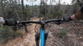
Avui 4 DEC 2022 hem estrenat el corriol d'En Petit. És el gos que durant molts anys ha acompanyat a qui ha fet molts dels corriols dels voltants.
Corriol que comença força pla amb alguns apoios i uns saltets molt petits. A la part mitjana té força més pendent amb algunes curves una mica tancades i amb una espècie de banyeres que molen molt. Finalment es torna més plana i amb un flow extrem al final de tot.

Recent Activity on Trail

Past Week
  • 2 rides
  • 17 miles average
6 Months
  • 106 rides
  • 19 miles avg distance
All
  • 325 rides
  • Last: Jun 12, 2026
c1c2c3c4
January
February
March
April
May
June
July
August
September
October
November
December
Status:
on May 17, 2026
Variable
Avg: 4.4 (24 votes)
Your vote: 0

view (2,735)
close
3D
Trail Conditions
  • Unknown
  • Snow Groomed
  • Snow Packed
  • Snow Covered
  • Snow Cover Partial
  • Freeze/thaw Cycle
  • Icy
  • Prevalent Mud
  • Wet
  • Variable
  • Ideal
  • Dry
  • Very Dry
Trail Flow (Ridden Direction)
Trailforks scans users ridelogs to determine the most popular direction each trail is ridden. A good flowing trail network will have most trails flowing in a single direction according to their intension.
The colour categories are based on what percentage of riders are riding a trail in its intended direction.
  • > 96%
  • > 90%
  • > 80%
  • > 70%
  • > 50%
  • < 50%
  • bi-directional trail
  • no data
Trail Last Ridden
Trailforks scans ridelogs to determine the last time a trail was ridden.
  • < 2 days
  • < 1 week
  • < 2 weeks
  • < 1 month
  • < 6 months
  • > 6 months
Trail Ridden Direction
The intended direction a trail should be ridden.
  • Downhill Only
  • Downhill Primary
  • Both Directions
  • Uphill Primary
  • Uphill Only
  • One Direction
Contribute Details
Colors indicate trail is missing specified detail.
  • Description
  • Photos
  • Description & Photos
  • Videos
Trail Popularity ?
Trailforks scans ridelogs to determine which trails are ridden the most in the last 9 months. Trails are compared with nearby trails in the same city region with a possible 25 colour shades. Think of this as a heatmap, more rides = more kinetic energy = warmer colors.
  • most popular
  • popular
  • less popular
  • not popular
ATV/ORV/OHV Filter
Max Vehicle Width
inches
US Cell Coverage
Legend
cell carrier legend

Radar Time
Activity Recordings
Trailforks uses anonymized public activity data. ?
Activity Recordings
Trailforks uses anonymized public activity data. ?
Personal Heatmap
Activity Types
all / none
Options
2
Date range month
Winter Trails
Warning A routing network for winter maps does not exist. Selecting trails using the winter trails layer has been disabled.
Missing Trails
Most Popular
Least Popular
Trails are colored based on popularity. The more popular a trail is, the more red. Less popular trails trend towards green.
Jump Magnitude Heatmap
Heatmap of where riders jump on trails. Zoom in to see individual jumps, click circles to view jump details.
BC Backroad Status

Service Road Atlas is a free to use, community-driven service for viewing and creating reports on the numerous back-country service roads around B.C. and Alberta.

map legend
Slope Aspect
Direction the slope faces
Flat N NE E SE S SW W NW
Trails Deemphasized
Trails are shown in grey.
disable
Only show trails with no bike usage.
Enable
Suggested Layers
Based on selected activity type

    Save the current map location and zoom level as your default home location whenever this page is loaded.

    Save
        Directions to en-petit-591089 trailhead (41.846790, 2.649170)

        Photos

        6 more »
        101 |
        Jan 31, 2023 @ 5:09am
        Jan 31, 2023
        107 |
        Jan 31, 2023 @ 5:09am
        Jan 31, 2023
        167 |
        Jan 3, 2023 @ 12:38pm
        Jan 3, 2023
        189 |
        Jan 3, 2023 @ 12:36pm
        Jan 3, 2023

        Videos

        0 more »
        youtuber Un altre corriol nou a Santa Coloma!! El Nen Petit
        4:33 | 427 | Mar 8, 2021 , Santa Coloma de Farners
        En Petit, Santa Coloma de Farners | enduro MTB...
        9:04 | 62 | Mar 29, 2026 , Santa Coloma de Farners
        MTB POV — En Petit (Catalan Winter)
        6:51 | 25 | Mar 3, 2026 , Santa Coloma de Farners
        ENTRENAMiENTO OFiCiAL ENDURO BTT LA SELVA...
        114 | Apr 1, 2023 , Santa Coloma de Farners

        Routes with this trail

        2.0 15 miles 3,508 ft 14 Loop
        Ruta para adentrarnos un poco más en la zona de Santa Coloma de Farners subiendo a la Ermita de para...
        22 miles 3,771 ft 25 Loop Race
        Recorregut oficial de BTT enduro La selva 2023

        8 Reviews & Comments


        We hope you've been enjoying Trailforks!

        Create a FREE account to view trail comments and much more.

        • By kiko67 & contributors
        • #591089 - 1,837 views

        Frequently Asked Questions About En Petit

        Where is En Petit located?
        En Petit is located in Riudarenes, Santa Coloma de Farners, Spain. It is part of the Riudarenes trail network. The trailhead is located at coordinates 41.84679, 2.64917.
        How hard is En Petit?
        En Petit is rated as Red difficulty. The physical rating is Moderate. The average grade is 13.4%.
        What is the elevation gain for En Petit?
        En Petit has 12 ft of elevation gain. The trail has 962 ft of elevation descent. The elevation ranges from 419 ft to 1,369 ft.
        Is En Petit a point to point trail?
        Yes, En Petit is a point to point trail. The direction is Downhill Only. The trail type is singletrack.

        Hit the Trail

        Open in App

        Get this trail on your phone instantly.
        open trail in app

        Download Trail

        Save to wishlist, Garmin & download.
        save the trail

        Find Related Routes

        Find routes and users activities that include this trail.
        find routes for this trail

        You must enter a description before submitting.