more stats
4,514 ft
Distance
79 ft
Climb
-52 ft
Descent
00:15:02
Avg time
28 ft
Altitude change
4,405 ft
Altitude min
4,484 ft
Altitude max
4,407 ft
Altitude start
4,436 ft
Altitude end
0.6%
Grade
-9.6%
Grade max
10.9%
Grade min
1,939 ft
Distance climb
1,818 ft
Distance down
682 ft
Distance flat
00:15:02
Avg time

Enchanted Forest Details

  • Activities
    • Mountain Bike
    • E-Bike
    • Hike
    • Trail Running
  • Riding Area
    Snowshoe Backcountry
    Snowshoe Village, West Virginia
  • Difficulty Rating
  • Local Popularity
    100 in Mountain Biking [+]
    • 100 in E-Biking
    • 90 in Trail Running
    • 85 in Hiking
  • Global Ranking
    #46775 in Mountain Biking [+]
    • #6416 in E-Biking
    • #50329 in Trail Running
    • #62859 in Hiking
  • Hiking SAC Scale
    T1 Hiking
  • Trail Type
    Singletrack
  • Bike Type
    AM, XC
  • Direction
    Both Directions
    Popular Direction Shown
  • Climb Difficulty
    Blue
  • Physical Rating
    Easy
  • Dogs Allowed
    Yes
  • eBike Allowed
    Yes up to Class 1
  • Ride in Rain
    Yes
  • Land Owner

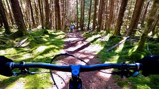
Great trail with lots of loam and rocks. There are lots of bridge sections to get you out of the mud. There are a couple of large boulders to ride over so the "climbing" aspect is a bit more technical. Be aware of wildlife as this area is very far from civilization and is very dense and quiet.

Access Info

Black Run Road

Local Trail Association
Traditionally Indigenous Territory

Recent Activity on Trail

Past Week
  • 0 rides
  •  
6 Months
  • 15 rides
  • 14 miles avg distance
All
  • 130 rides
  • Last: Jun 24, 2026
c1c2c3c4
January
February
March
April
May
June
July
August
September
October
November
December
Status:
on May 16, 2026
Ideal
Avg: 4.27 (5 votes)
Your vote: 0

view (970)
close
3D
Trail Conditions
  • Unknown
  • Snow Groomed
  • Snow Packed
  • Snow Covered
  • Snow Cover Partial
  • Freeze/thaw Cycle
  • Icy
  • Prevalent Mud
  • Wet
  • Variable
  • Ideal
  • Dry
  • Very Dry
Trail Flow (Ridden Direction)
Trailforks scans users ridelogs to determine the most popular direction each trail is ridden. A good flowing trail network will have most trails flowing in a single direction according to their intension.
The colour categories are based on what percentage of riders are riding a trail in its intended direction.
  • > 96%
  • > 90%
  • > 80%
  • > 70%
  • > 50%
  • < 50%
  • bi-directional trail
  • no data
Trail Last Ridden
Trailforks scans ridelogs to determine the last time a trail was ridden.
  • < 2 days
  • < 1 week
  • < 2 weeks
  • < 1 month
  • < 6 months
  • > 6 months
Trail Ridden Direction
The intended direction a trail should be ridden.
  • Downhill Only
  • Downhill Primary
  • Both Directions
  • Uphill Primary
  • Uphill Only
  • One Direction
Contribute Details
Colors indicate trail is missing specified detail.
  • Description
  • Photos
  • Description & Photos
  • Videos
Trail Popularity ?
Trailforks scans ridelogs to determine which trails are ridden the most in the last 9 months. Trails are compared with nearby trails in the same city region with a possible 25 colour shades. Think of this as a heatmap, more rides = more kinetic energy = warmer colors.
  • most popular
  • popular
  • less popular
  • not popular
ATV/ORV/OHV Filter
Max Vehicle Width
inches
US Cell Coverage
Legend
cell carrier legend

Radar Time
Activity Recordings
Trailforks uses anonymized public activity data. ?
Activity Recordings
Trailforks uses anonymized public activity data. ?
Personal Heatmap
Activity Types
all / none
Options
2
Date range month
Winter Trails
Warning A routing network for winter maps does not exist. Selecting trails using the winter trails layer has been disabled.
Missing Trails
Most Popular
Least Popular
Trails are colored based on popularity. The more popular a trail is, the more red. Less popular trails trend towards green.
Jump Magnitude Heatmap
Heatmap of where riders jump on trails. Zoom in to see individual jumps, click circles to view jump details.
BC Backroad Status

Service Road Atlas is a free to use, community-driven service for viewing and creating reports on the numerous back-country service roads around B.C. and Alberta.

map legend
Slope Aspect
Direction the slope faces
Flat N NE E SE S SW W NW
Trails Deemphasized
Trails are shown in grey.
disable
Only show trails with no bike usage.
Enable
Suggested Layers
Based on selected activity type

    Save the current map location and zoom level as your default home location whenever this page is loaded.

    Save
        Directions to enchanted-forest-61696 trailhead (38.452630, -80.003550)

        Photos

        4 more »
        164 |
        Oct 1, 2023 @ 6:31am
        Oct 1, 2023
        221 |
        Aug 1, 2022 @ 5:53am
        Aug 1, 2022
        64 |
        May 2, 2025 @ 3:00pm
        May 2, 2025
        63 |
        Oct 12, 2024 @ 4:36pm
        Oct 12, 2024

        Videos

        1 more »
        The Best Snowshoe Backcountry Route | Mountain...
        14:05 | 274 | Jul 27, 2022 , Snowshoe Village

        Routes with this trail

        12 miles 1,430 ft 9
        From the Snowshoe Mountain official blog:
        12 miles 1,387 ft 10
        Starting at the Corduroy Lodge, a long hiking loop that goes through the fingers then the airport....
        5 miles 847 ft 7 Loop
        A route I want to try in the back country of Snowshoe.

        1 Review & Comments


        We hope you've been enjoying Trailforks!

        Create a FREE account to view trail comments and much more.

        • By whiplashingitis & contributors
        • #61696 - 3,662 views

        Frequently Asked Questions About Enchanted Forest

        Where is Enchanted Forest located?
        Enchanted Forest is located in Snowshoe Backcountry, Snowshoe Village, West Virginia, United States. It is part of the Snowshoe Backcountry trail network. The trailhead is located at coordinates 38.45263, -80.00355.
        How hard is Enchanted Forest?
        Enchanted Forest is rated as Blue difficulty. The physical rating is Easy. The average grade is 0.6%. The climb difficulty is rated Blue.
        What is the elevation gain for Enchanted Forest?
        Enchanted Forest has 79 ft of elevation gain. The trail has 52 ft of elevation descent. The elevation ranges from 4,405 ft to 4,484 ft.
        Is Enchanted Forest a point to point trail?
        Enchanted Forest is not a point to point trail. The direction is Both Directions. The trail type is singletrack.

        Hit the Trail

        Open in App

        Get this trail on your phone instantly.
        open trail in app

        Download Trail

        Save to wishlist, Garmin & download.
        save the trail

        Find Related Routes

        Find routes and users activities that include this trail.
        find routes for this trail

        You must enter a description before submitting.