more stats
2,835 ft
Distance
2 ft
Climb
-356 ft
Descent
00:04:23
Avg time
-353 ft
Altitude change
1,914 ft
Altitude min
2,267 ft
Altitude max
2,267 ft
Altitude start
1,913 ft
Altitude end
-12.5%
Grade
-45.8%
Grade max
2.4%
Grade min
253 ft
Distance climb
2,507 ft
Distance down
75 ft
Distance flat
00:04:23
Avg time

Enduline Details

  • Activities
    • Mountain Bike
    • E-Bike
  • Riding Area
    Rocallaura Bikepark
    Rocallaura
  • Difficulty Rating
  • Voted Difficulty
    Red (2 votes)
  • Local Popularity
    50 in Mountain Biking [+]
    • 50 in E-Biking
  • Global Ranking
    #27831 in Mountain Biking [+]
    • #746 in E-Biking
  • Trail Type
    Singletrack
  • Bike Type
    AM
  • Direction
    Downhill Only
    Popular Direction Shown
  • Physical Rating
    Moderate
  • Trail Visibility
    Always easy to follow
  • eBike Allowed
    Yes up to Class 1
  • TTFs on Trail
    Berm, Drop, Jump, Wallride
  • Year Opened
    2022
  • Land Owner
    Antic Balneari de Rocallaura

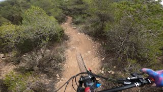
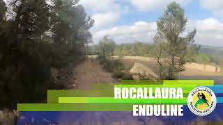
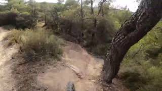
El trail més exigent de Rocallaura Bikepark, que obliga a aplicar-se en tot el seu recorregut. Mateix inici que Solana i igual que aquesta, té 3 encreuaments amb Remuntada (PRECAUCIÓ). Hi trobarem un tram inicial de flow, seguint amb un tram força vertical amb constraperalts, roques i drops. La pendent va disminuïnt després del 3r encreuament amb Remuntada per donar pas a un tram puja-baixa trencat. Precaució amb els salts a vista i amb la sortida que dona a la carretera. El tram d'Strava acaba abans de la baixada a la carretera.

Access Info

Mateix que Remuntada

Trail Supporters
Local Trail Association

Recent Activity on Trail

Past Week
  • 0 rides
  •  
6 Months
  • 5 rides
  • 12 miles avg distance
All
  • 54 rides
  • Last: Jun 20, 2026
c1c2c3c4
January
February
March
April
May
June
July
August
September
October
November
December
Status:
on Feb 14, 2026
Ideal
Avg: 4.15 (9 votes)
Your vote: 0

view (777)
close
3D
Trail Conditions
  • Unknown
  • Snow Groomed
  • Snow Packed
  • Snow Covered
  • Snow Cover Partial
  • Freeze/thaw Cycle
  • Icy
  • Prevalent Mud
  • Wet
  • Variable
  • Ideal
  • Dry
  • Very Dry
Trail Flow (Ridden Direction)
Trailforks scans users ridelogs to determine the most popular direction each trail is ridden. A good flowing trail network will have most trails flowing in a single direction according to their intension.
The colour categories are based on what percentage of riders are riding a trail in its intended direction.
  • > 96%
  • > 90%
  • > 80%
  • > 70%
  • > 50%
  • < 50%
  • bi-directional trail
  • no data
Trail Last Ridden
Trailforks scans ridelogs to determine the last time a trail was ridden.
  • < 2 days
  • < 1 week
  • < 2 weeks
  • < 1 month
  • < 6 months
  • > 6 months
Trail Ridden Direction
The intended direction a trail should be ridden.
  • Downhill Only
  • Downhill Primary
  • Both Directions
  • Uphill Primary
  • Uphill Only
  • One Direction
Contribute Details
Colors indicate trail is missing specified detail.
  • Description
  • Photos
  • Description & Photos
  • Videos
Trail Popularity ?
Trailforks scans ridelogs to determine which trails are ridden the most in the last 9 months. Trails are compared with nearby trails in the same city region with a possible 25 colour shades. Think of this as a heatmap, more rides = more kinetic energy = warmer colors.
  • most popular
  • popular
  • less popular
  • not popular
ATV/ORV/OHV Filter
Max Vehicle Width
inches
US Cell Coverage
Legend
cell carrier legend

Radar Time
Activity Recordings
Trailforks uses anonymized public activity data. ?
Activity Recordings
Trailforks uses anonymized public activity data. ?
Personal Heatmap
Activity Types
all / none
Options
2
Date range month
Winter Trails
Warning A routing network for winter maps does not exist. Selecting trails using the winter trails layer has been disabled.
Missing Trails
Most Popular
Least Popular
Trails are colored based on popularity. The more popular a trail is, the more red. Less popular trails trend towards green.
Jump Magnitude Heatmap
Heatmap of where riders jump on trails. Zoom in to see individual jumps, click circles to view jump details.
BC Backroad Status

Service Road Atlas is a free to use, community-driven service for viewing and creating reports on the numerous back-country service roads around B.C. and Alberta.

map legend
Slope Aspect
Direction the slope faces
Flat N NE E SE S SW W NW
Trails Deemphasized
Trails are shown in grey.
disable
Only show trails with no bike usage.
Enable
Suggested Layers
Based on selected activity type

    Save the current map location and zoom level as your default home location whenever this page is loaded.

    Save
        Directions to enduline trailhead (41.512530, 1.138970)

        Photos

        0 more »
        30 |
        Jan 20, 2024 @ 12:41am
        Jan 20, 2024

        Videos

        4 more »
        Enduline 2024 // Rocallaura
        2:22 | 227 | Jan 22, 2024 , Rocallaura
        PROBANDO LA #ENDULINE DEL #ROCALLAURABIKEPARK,...
        7:15 | 144 | Aug 3, 2023 , Rocallaura
        Rocallaura bikepark - Enduline
        3:33 | 148 | Jun 4, 2023 , Rocallaura
        Pov: Enduline Rocallaura
        2:41 | 203 | Feb 27, 2023 , Rocallaura

        1 Review & Comments


        We hope you've been enjoying Trailforks!

        Create a FREE account to view trail comments and much more.

        • By bandidosTF Pro & contributors
        • #582166 - 707 views

        Frequently Asked Questions About Enduline

        Where is Enduline located?
        Enduline is located in Rocallaura Bikepark, Rocallaura, Spain. It is part of the Rocallaura Bikepark trail network. The trailhead is located at coordinates 41.51253, 1.13897.
        How hard is Enduline?
        Enduline is rated as Red difficulty. The physical rating is Moderate. The average grade is 12.5%.
        What is the elevation gain for Enduline?
        Enduline has 2 ft of elevation gain. The trail has 356 ft of elevation descent. The elevation ranges from 1,914 ft to 2,267 ft.
        Is Enduline a point to point trail?
        Yes, Enduline is a point to point trail. The direction is Downhill Only. The trail type is singletrack.

        Hit the Trail

        Open in App

        Get this trail on your phone instantly.
        open trail in app

        Download Trail

        Save to wishlist, Garmin & download.
        save the trail

        Find Related Routes

        Find routes and users activities that include this trail.
        find routes for this trail

        You must enter a description before submitting.