more stats
2,014 ft
Distance
-336 ft
Descent
1,372 ft
High Point
-336 ft
Altitude change
1,036 ft
Altitude min
1,372 ft
Altitude start
1,037 ft
Altitude end
-16.7%
Grade
-95.7%
Grade max
-1.2%
Grade min
1,959 ft
Distance down
56 ft
Distance flat

Enro Details

  • Activities
    • Mountain Bike
    • E-Bike
  • Riding Area
  • Difficulty Rating
  • Local Popularity
    85 in Mountain Biking [+]
    • 100 in E-Biking
  • Global Ranking
    #150109 in Mountain Biking [+]
    • #9627 in E-Biking
  • Trail Type
    Singletrack
  • Bike Type
    DH, AM
  • Direction
    Downhill Only[+]
    Popular Direction Shown
    • Downhill Only for E-Biking
  • Physical Rating
    Moderate
  • Trail Visibility
    Sometimes hard to follow
  • eBike Allowed
    Yes up to Class 1
  • TTFs on Trail
    Berm, Bridge, Drop
  • Land Owner
    Urbariálne pozemkové spoločenstvo Bardejovská Nová Ves

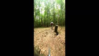
Enro je prírodný enduro trail vedený v technickom lesnom teréne. Trasa je charakteristická množstvom koreňov, odklonených úsekov, neprehľadných zákrut a úzkych prejazdov medzi stromami. Na trati sa nachádza aj niekoľko dropov a úzkych prejazdov pomedzi stromy, ktoré vyžadujú dobrú techniku jazdy.

Vzhľadom na svoj charakter je trail určený pokročilým jazdcom, najmä za mokra alebo po daždi.

V závere trailu nasleduje sekcia Pinball – prejazd medzi stromami cez prírodné vlny. Za ňou si jazdec môže vybrať z dvoch smerov - vľavo séria štyroch prepadov, tzv. Kaskády, vpravo dva prudké zrázy vedúce priamo na lesnú zvážnicu.

Local Trail Association

Recent Activity on Trail

Past Week
  • 0 rides
  •  
6 Months
  • 3 rides
  • 10 miles avg distance
All
  • 13 rides
  • Last: May 10, 2026
c1c2c3c4
January
February
March
April
May
June
July
August
September
October
November
December
update trails status or condition

Enro Trail Reports

statusdatedescription
Nov 10, 2024 @ 7:02am
Nov 10, 2024
reporter Fajne vyfukane, suchucke, len jazdit
more »
Status:
on Nov 10, 2024
Dry
Avg: 4.13 (1 votes)
Your vote: 0

view (214)
close
3D
Trail Conditions
  • Unknown
  • Snow Groomed
  • Snow Packed
  • Snow Covered
  • Snow Cover Partial
  • Freeze/thaw Cycle
  • Icy
  • Prevalent Mud
  • Wet
  • Variable
  • Ideal
  • Dry
  • Very Dry
Trail Flow (Ridden Direction)
Trailforks scans users ridelogs to determine the most popular direction each trail is ridden. A good flowing trail network will have most trails flowing in a single direction according to their intension.
The colour categories are based on what percentage of riders are riding a trail in its intended direction.
  • > 96%
  • > 90%
  • > 80%
  • > 70%
  • > 50%
  • < 50%
  • bi-directional trail
  • no data
Trail Last Ridden
Trailforks scans ridelogs to determine the last time a trail was ridden.
  • < 2 days
  • < 1 week
  • < 2 weeks
  • < 1 month
  • < 6 months
  • > 6 months
Trail Ridden Direction
The intended direction a trail should be ridden.
  • Downhill Only
  • Downhill Primary
  • Both Directions
  • Uphill Primary
  • Uphill Only
  • One Direction
Contribute Details
Colors indicate trail is missing specified detail.
  • Description
  • Photos
  • Description & Photos
  • Videos
Trail Popularity ?
Trailforks scans ridelogs to determine which trails are ridden the most in the last 9 months. Trails are compared with nearby trails in the same city region with a possible 25 colour shades. Think of this as a heatmap, more rides = more kinetic energy = warmer colors.
  • most popular
  • popular
  • less popular
  • not popular
ATV/ORV/OHV Filter
Max Vehicle Width
inches
US Cell Coverage
Legend
cell carrier legend

Radar Time
Activity Recordings
Trailforks uses anonymized public activity data. ?
Activity Recordings
Trailforks uses anonymized public activity data. ?
Personal Heatmap
Activity Types
all / none
Options
2
Date range month
Winter Trails
Warning A routing network for winter maps does not exist. Selecting trails using the winter trails layer has been disabled.
Missing Trails
Most Popular
Least Popular
Trails are colored based on popularity. The more popular a trail is, the more red. Less popular trails trend towards green.
Jump Magnitude Heatmap
Heatmap of where riders jump on trails. Zoom in to see individual jumps, click circles to view jump details.
BC Backroad Status

Service Road Atlas is a free to use, community-driven service for viewing and creating reports on the numerous back-country service roads around B.C. and Alberta.

map legend
Slope Aspect
Direction the slope faces
Flat N NE E SE S SW W NW
Trails Deemphasized
Trails are shown in grey.
disable
Only show trails with no bike usage.
Enable
Suggested Layers
Based on selected activity type

    Save the current map location and zoom level as your default home location whenever this page is loaded.

    Save
        Directions to enro trailhead (49.310130, 21.326310)

        Photos

        6 more »
        51 |
        Nov 12, 2024 @ 1:23pm
        Nov 12, 2024
        49 |
        Nov 12, 2024 @ 1:22pm
        Nov 12, 2024
        51 |
        Nov 12, 2024 @ 1:21pm
        Nov 12, 2024
        44 |
        Nov 12, 2024 @ 1:20pm
        Nov 12, 2024

        Videos

        1 more »
        'Enro' Bardejovská Nová Ves, 30.6.2024 za Peťom
        2:38 | 191 | Jul 26, 2024 , Bardejov

        Reviews / Comments

        No reviews yet, be the first to write a review or ask a question.
        Use trail reports to comment on trail conditions.


        We hope you've been enjoying Trailforks!

        Create a FREE account to view trail comments and much more.

        • By popjak LSBK & contributors
        • #779297 - 236 views

        Frequently Asked Questions About Enro

        Where is Enro located?
        Enro is located in Bardejovská Nová Ves, Bardejov, Slovakia. It is part of the Bardejovská Nová Ves trail network. The trailhead is located at coordinates 49.31013, 21.32631.
        How hard is Enro?
        Enro is rated as Black difficulty. The physical rating is Moderate. The average grade is 16.7%.
        What is the elevation gain for Enro?
        The trail has 336 ft of elevation descent. The elevation ranges from 1,036 ft to 1,372 ft.
        Is Enro a point to point trail?
        Yes, Enro is a point to point trail. The direction is Downhill Only. The trail type is singletrack.

        Hit the Trail

        Open in App

        Get this trail on your phone instantly.
        open trail in app

        Download Trail

        Save to wishlist, Garmin & download.
        save the trail

        Find Related Routes

        Find routes and users activities that include this trail.
        find routes for this trail

        You must enter a description before submitting.