more stats
9.3 miles
Distance
591 ft
Climb
-596 ft
Descent
01:03:44
Avg time
-4 ft
Altitude change
587 ft
Altitude min
705 ft
Altitude max
647 ft
Altitude start
643 ft
Altitude end
-12.9%
Grade max
11.2%
Grade min
3 miles
Distance climb
3 miles
Distance down
3 miles
Distance flat
01:03:44
Avg time

Erwin Park Details

  • Activities
    • Mountain Bike
    • E-Bike
    • Winter Fat Bike
    • Hike
    • Trail Running
  • Riding Area
    Erwin Park
    McKinney, Texas
  • Difficulty Rating
  • Voted Difficulty
    Blue (1 vote)
  • Local Popularity
    80 in Mountain Biking [+]
    • 90 in E-Biking
    • 40 in Trail Running
    • 85 in Hiking
  • Global Ranking
    #10169 in Mountain Biking [+]
    • #16849 in E-Biking
    • #21701 in Trail Running
  • Hiking SAC Scale
    T2 Mountain Hiking
  • Trail Type
    Singletrack
  • Bike Type
    DH, AM, XC, Fat
  • Direction
    Both Directions
  • Climb Difficulty
    Green
  • Physical Rating
    Moderate
  • Trail Visibility
    Always easy to follow
  • Season
    Jan-Dec
  • Family Friendly
    Yes
  • Dogs Allowed
    Yes
  • eBike Allowed
    Yes up to Class 1
  • TTFs on Trail
    Berm, Bridge, Jump, Ladder Bridge
  • Land Owner

The trail is maintained by the Dallas Off Road Bicycle Association (dorba.org)

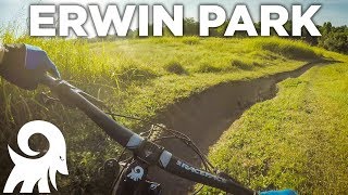
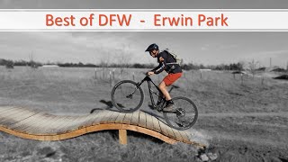
Erwin Park is a city of McKinney public park. The trail is just around 8.1 miles. The trail is a mix of tight and twisty in the woods to some fast open field sections. There is plenty of climbing to get your heart rate up. Since you're going up, there are some fast and fun downhills as well. There are some technical sections and most of the technical sections have alternate (easy) routes around them. The trail does have some dips. The last section of trail is called the expert section. There is an alternate route to your left crossing a bridge (left - easy; right - hard). This is the only alternate route with a bridge. Camping is allowed for a very nominal fee. Contact the city community center at 972-547-2690. They are located on the north bound service road of central, north of Eldorado Parkway.

The trail is closed when it's wet and DORBA does an awesome job keeping trial status updated - visit the site and get the app.

source: Erwin Park
Access Info

After entering the park follow the winding paved street and stay left at the fork. There's a parking lot visible on the right and many people park here and access the trail. If you continue a little farther down there's another parking lot which is the true trail head with trail map posted. There are restrooms at this second lot and a bike service station at the trail head.

Trail Supporters
Local Trail Association
Traditionally Indigenous Territory

Recent Activity on Trail

Past Week
  • 1 rides
  • 10 miles average
6 Months
  • 73 rides
  • 21 miles avg distance
All
  • 784 rides
  • Last: Jun 6, 2026
c1c2c3c4
January
February
March
April
May
June
July
August
September
October
November
December
Status:
on Jun 19, 2026
Wet
Avg: 4.16 (25 votes)
Your vote: 0

view (8,073)
close
3D
Trail Conditions
  • Unknown
  • Snow Groomed
  • Snow Packed
  • Snow Covered
  • Snow Cover Partial
  • Freeze/thaw Cycle
  • Icy
  • Prevalent Mud
  • Wet
  • Variable
  • Ideal
  • Dry
  • Very Dry
Trail Flow (Ridden Direction)
Trailforks scans users ridelogs to determine the most popular direction each trail is ridden. A good flowing trail network will have most trails flowing in a single direction according to their intension.
The colour categories are based on what percentage of riders are riding a trail in its intended direction.
  • > 96%
  • > 90%
  • > 80%
  • > 70%
  • > 50%
  • < 50%
  • bi-directional trail
  • no data
Trail Last Ridden
Trailforks scans ridelogs to determine the last time a trail was ridden.
  • < 2 days
  • < 1 week
  • < 2 weeks
  • < 1 month
  • < 6 months
  • > 6 months
Trail Ridden Direction
The intended direction a trail should be ridden.
  • Downhill Only
  • Downhill Primary
  • Both Directions
  • Uphill Primary
  • Uphill Only
  • One Direction
Contribute Details
Colors indicate trail is missing specified detail.
  • Description
  • Photos
  • Description & Photos
  • Videos
Trail Popularity ?
Trailforks scans ridelogs to determine which trails are ridden the most in the last 9 months. Trails are compared with nearby trails in the same city region with a possible 25 colour shades. Think of this as a heatmap, more rides = more kinetic energy = warmer colors.
  • most popular
  • popular
  • less popular
  • not popular
ATV/ORV/OHV Filter
Max Vehicle Width
inches
US Cell Coverage
Legend
cell carrier legend

Radar Time
Activity Recordings
Trailforks uses anonymized public activity data. ?
Activity Recordings
Trailforks uses anonymized public activity data. ?
Personal Heatmap
Activity Types
all / none
Options
2
Date range month
Winter Trails
Warning A routing network for winter maps does not exist. Selecting trails using the winter trails layer has been disabled.
Missing Trails
Most Popular
Least Popular
Trails are colored based on popularity. The more popular a trail is, the more red. Less popular trails trend towards green.
Jump Magnitude Heatmap
Heatmap of where riders jump on trails. Zoom in to see individual jumps, click circles to view jump details.
BC Backroad Status

Service Road Atlas is a free to use, community-driven service for viewing and creating reports on the numerous back-country service roads around B.C. and Alberta.

map legend
Slope Aspect
Direction the slope faces
Flat N NE E SE S SW W NW
Trails Deemphasized
Trails are shown in grey.
disable
Only show trails with no bike usage.
Enable
Suggested Layers
Based on selected activity type

    Save the current map location and zoom level as your default home location whenever this page is loaded.

    Save
        Directions to erwin-park trailhead (33.254730, -96.654790)

        Photos

        39 more »
        97 |
        Jan 20, 2026 @ 8:22am
        Jan 20, 2026
        229 |
        Aug 15, 2023 @ 12:37pm
        Aug 15, 2023
        550 |
        Apr 12, 2022 @ 4:00am
        Apr 12, 2022
        508 |
        Apr 12, 2022 @ 4:00am
        Apr 12, 2022

        Videos

        13 more »
        youtuber Mountain Biking at Erwin Park | New &...
        9:20 | 1558 | Jul 18, 2019 , McKinney
        The Upgrades Keep Comin | Mountain Biking...
        12:43 | 118 | Jan 19, 2026 , McKinney
        Sick New Jump Park || Erwin Park 2022...
        7:14 | 1122 | Jun 29, 2022 , McKinney
        Erwin Park Highlights
        3:15 | 1327 | Jun 3, 2022 , McKinney

        Routes with this trail

        11 miles 613 ft 5 Race
        This is the route for the 100 mile participants in the 2024 DORBA Judgment Day.
        9 miles 514 ft 4 Race
        This is the 70 mile route for the 2024 DORBA Judgment Day.

        7 Reviews & Comments


        We hope you've been enjoying Trailforks!

        Create a FREE account to view trail comments and much more.

        • By toddTF Pro Trailforks & contributors
        • #15704 - 19,127 views

        Frequently Asked Questions About Erwin Park

        Where is Erwin Park located?
        Erwin Park is located in Erwin Park, McKinney, Texas, United States. It is part of the Erwin Park trail network. The trailhead is located at coordinates 33.25473, -96.65479.
        How hard is Erwin Park?
        Erwin Park is rated as Blue difficulty. The physical rating is Moderate. The climb difficulty is rated Green.
        What is the elevation gain for Erwin Park?
        Erwin Park has 180 m of elevation gain. The trail has 182 m of elevation descent. The elevation ranges from 179 m to 215 m.
        Is Erwin Park a point to point trail?
        Erwin Park is not a point to point trail. The direction is Both Directions. The trail type is singletrack.

        Hit the Trail

        Open in App

        Get this trail on your phone instantly.
        open trail in app

        Download Trail

        Save to wishlist, Garmin & download.
        save the trail

        Find Related Routes

        Find routes and users activities that include this trail.
        find routes for this trail

        You must enter a description before submitting.