more stats
1,791 ft
Distance
-89 ft
Descent
00:01:54
Avg time
-89 ft
Altitude change
2,036 ft
Altitude min
2,125 ft
Altitude max
2,125 ft
Altitude start
2,037 ft
Altitude end
-5%
Grade
-17.9%
Grade max
0.3%
Grade min
1,529 ft
Distance down
46 ft
Distance flat
00:01:54
Avg time

Evolution Jump Trail Details

  • Activities
    • Mountain Bike
  • Riding Area
  • Difficulty Rating
  • Local Popularity
    90 in Mountain Biking
  • Global Ranking
    #3218 in Mountain Biking
  • Trail Type
    Singletrack
  • Bike Type
    AM, DJ, Adaptive MTB
  • eBike Allowed
    Yes up to Class 1
  • TTFs on Trail
    Jump
  • Land Owner
    CMTEDD - National Arboretum Canberra/Stromlo Forest Park

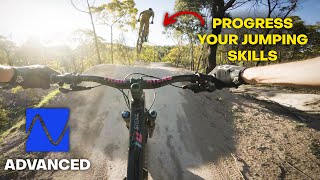
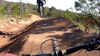
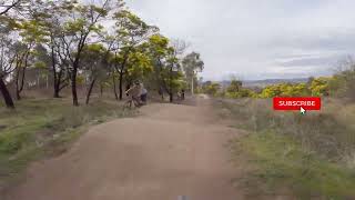
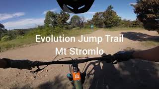
Evolution is Mt Stromlo's progressive coaching trail. It consists of one jump after another from start to finish, which are sized so that the trail speed of nailing one jump sets you up nicely for the next one. It begins with tiny tables and ends with larger doubles so you need to progress as you descend.

Bike Park

Traditionally Indigenous Territory

Recent Activity on Trail

Past Week
  • 6 rides
  • 12 miles average
6 Months
  • 264 rides
  • 12 miles avg distance
All
  • 2,064 rides
  • Last: Jun 22, 2026
c1c2c3c4
January
February
March
April
May
June
July
August
September
October
November
December
Status:
on Jun 4, 2025
Ideal
Avg: 4.26 (5 votes)
Your vote: 0

view (21,924)
close
3D
Trail Conditions
  • Unknown
  • Snow Groomed
  • Snow Packed
  • Snow Covered
  • Snow Cover Partial
  • Freeze/thaw Cycle
  • Icy
  • Prevalent Mud
  • Wet
  • Variable
  • Ideal
  • Dry
  • Very Dry
Trail Flow (Ridden Direction)
Trailforks scans users ridelogs to determine the most popular direction each trail is ridden. A good flowing trail network will have most trails flowing in a single direction according to their intension.
The colour categories are based on what percentage of riders are riding a trail in its intended direction.
  • > 96%
  • > 90%
  • > 80%
  • > 70%
  • > 50%
  • < 50%
  • bi-directional trail
  • no data
Trail Last Ridden
Trailforks scans ridelogs to determine the last time a trail was ridden.
  • < 2 days
  • < 1 week
  • < 2 weeks
  • < 1 month
  • < 6 months
  • > 6 months
Trail Ridden Direction
The intended direction a trail should be ridden.
  • Downhill Only
  • Downhill Primary
  • Both Directions
  • Uphill Primary
  • Uphill Only
  • One Direction
Contribute Details
Colors indicate trail is missing specified detail.
  • Description
  • Photos
  • Description & Photos
  • Videos
Trail Popularity ?
Trailforks scans ridelogs to determine which trails are ridden the most in the last 9 months. Trails are compared with nearby trails in the same city region with a possible 25 colour shades. Think of this as a heatmap, more rides = more kinetic energy = warmer colors.
  • most popular
  • popular
  • less popular
  • not popular
ATV/ORV/OHV Filter
Max Vehicle Width
inches
US Cell Coverage
Legend
cell carrier legend

Radar Time
Activity Recordings
Trailforks uses anonymized public activity data. ?
Activity Recordings
Trailforks uses anonymized public activity data. ?
Personal Heatmap
Activity Types
all / none
Options
2
Date range month
Winter Trails
Warning A routing network for winter maps does not exist. Selecting trails using the winter trails layer has been disabled.
Missing Trails
Most Popular
Least Popular
Trails are colored based on popularity. The more popular a trail is, the more red. Less popular trails trend towards green.
Jump Magnitude Heatmap
Heatmap of where riders jump on trails. Zoom in to see individual jumps, click circles to view jump details.
BC Backroad Status

Service Road Atlas is a free to use, community-driven service for viewing and creating reports on the numerous back-country service roads around B.C. and Alberta.

map legend
Slope Aspect
Direction the slope faces
Flat N NE E SE S SW W NW
Trails Deemphasized
Trails are shown in grey.
disable
Only show trails with no bike usage.
Enable
Suggested Layers
Based on selected activity type

    Save the current map location and zoom level as your default home location whenever this page is loaded.

    Save
        Directions to evolution-jump-trail trailhead (-35.325080, 149.016190)

        Photos

        4 more »
        59 |
        Nov 9, 2024 @ 12:22pm
        Nov 9, 2024
        125 |
        Feb 19, 2024 @ 3:54am
        Feb 19, 2024
        197 |
        Sep 14, 2020 @ 12:16am
        Sep 14, 2020
        259 |
        Sep 14, 2020 @ 12:16am
        Sep 14, 2020

        Videos

        7 more »
        youtuber Learn to Jump your MTB in Canberra | Evolution...
        0:12 | 235 | Sep 4, 2024 , Canberra
        Stromlo mountain biking (updated Evolution...
        0:02 | 295 | Dec 24, 2024 , Canberra
        Stromlo Evolution Jump Line for the over 50's
        0:20 | 255 | Sep 15, 2023 , Canberra
        Mt Stromlo | Evolution Jump Trail
        0:16 | 331 | Jan 1, 2022 , Canberra

        Routes with this trail

        41 miles 7,928 ft 115 Loop
        Planning for a Stromlo big loop
        40 miles 6,253 ft 118
        Full set of Stromlo trails, missing only a B line and short links.
        12 miles 1,799 ft 24 Loop
        Packed your legs? This ride hits up some of Stromlos steepest, most technical climbs - but doesn't muck...

        1 Review & Comments


        We hope you've been enjoying Trailforks!

        Create a FREE account to view trail comments and much more.

        • By Jake-HannahTF Pro MPTA & contributors
        • #325155 - 3,450 views

        Frequently Asked Questions About Evolution Jump Trail

        Where is Evolution Jump Trail located?
        Evolution Jump Trail is located in Stromlo Forest Park, Canberra, Australia. It is part of the Stromlo Forest Park trail network. The trailhead is located at coordinates -35.32508, 149.01619.
        How hard is Evolution Jump Trail?
        Evolution Jump Trail is rated as Blue difficulty. The average grade is 5%.
        What is the elevation gain for Evolution Jump Trail?
        The trail has 91 ft of elevation descent. The elevation ranges from 2,033 ft to 2,125 ft.
        How long is Evolution Jump Trail?
        Evolution Jump Trail is 1,827 ft long. The trail type is singletrack.

        Hit the Trail

        Open in App

        Get this trail on your phone instantly.
        open trail in app

        Download Trail

        Save to wishlist, Garmin & download.
        save the trail

        Find Related Routes

        Find routes and users activities that include this trail.
        find routes for this trail

        You must enter a description before submitting.