more stats
1,175 ft
Distance
11 ft
Climb
-94 ft
Descent
00:03:15
Avg time
-83 ft
Altitude change
636 ft
Altitude min
730 ft
Altitude max
730 ft
Altitude start
646 ft
Altitude end
-7.1%
Grade
-26.6%
Grade max
15.1%
Grade min
305 ft
Distance climb
869 ft
Distance down
00:03:15
Avg time

ExtremeCycles Details

  • Activities
    • Mountain Bike
    • E-Bike
    • Hike
    • Trail Running
  • Riding Area
    Mizzou Club Cycling Complex
    Columbia, Missouri
  • Difficulty Rating
  • Local Popularity
    50 in Mountain Biking [+]
    • 5 in E-Biking
    • 5 in Trail Running
    • 5 in Hiking
  • Trail Type
    Singletrack
  • Bike Type
    DH, AM
  • Direction
    Downhill Only
    Popular Direction Shown
  • Physical Rating
    Moderate
  • Trail Visibility
    Always easy to follow
  • Dogs Allowed
    Yes
  • eBike Allowed
    Yes up to Class 1
  • TTFs on Trail
    Berm, Drop, Jump, Rock Face
  • Land Owner

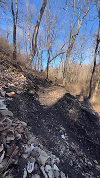
The DH trail for the Mizzou Club Cycling team. A fast and straight shot down the hill with several features. There are several berms and rock drops that are on this trail. A large catch berm at the bottom sends you into a screed shoot out to end the trail across the creek. High speed combined with clunk make for a fast and fun time. Look before you leap to make sure that you know what's coming up. Send or be sent

Recent Activity on Trail

Past Week
  • 0 rides
  •  
6 Months
  • 3 rides
  • 8 miles avg distance
All
  • 12 rides
  • Last: May 15, 2026
c1c2c3c4
January
February
March
April
May
June
July
August
September
October
November
December
update trails status or condition

ExtremeCycles Trail Reports

statusdatedescription
Sep 16, 2023 @ 7:16pm
Sep 16, 2023
Recent work by the University of Missouri Cycling Club has greatly improved the DH track! Due to these recent changes please walk the trail prior...
more »
Status:
on Sep 16, 2023
Avg: 4.24 (2 votes)
Your vote: 0

view (69)
close
3D
Trail Conditions
  • Unknown
  • Snow Groomed
  • Snow Packed
  • Snow Covered
  • Snow Cover Partial
  • Freeze/thaw Cycle
  • Icy
  • Prevalent Mud
  • Wet
  • Variable
  • Ideal
  • Dry
  • Very Dry
Trail Flow (Ridden Direction)
Trailforks scans users ridelogs to determine the most popular direction each trail is ridden. A good flowing trail network will have most trails flowing in a single direction according to their intension.
The colour categories are based on what percentage of riders are riding a trail in its intended direction.
  • > 96%
  • > 90%
  • > 80%
  • > 70%
  • > 50%
  • < 50%
  • bi-directional trail
  • no data
Trail Last Ridden
Trailforks scans ridelogs to determine the last time a trail was ridden.
  • < 2 days
  • < 1 week
  • < 2 weeks
  • < 1 month
  • < 6 months
  • > 6 months
Trail Ridden Direction
The intended direction a trail should be ridden.
  • Downhill Only
  • Downhill Primary
  • Both Directions
  • Uphill Primary
  • Uphill Only
  • One Direction
Contribute Details
Colors indicate trail is missing specified detail.
  • Description
  • Photos
  • Description & Photos
  • Videos
Trail Popularity ?
Trailforks scans ridelogs to determine which trails are ridden the most in the last 9 months. Trails are compared with nearby trails in the same city region with a possible 25 colour shades. Think of this as a heatmap, more rides = more kinetic energy = warmer colors.
  • most popular
  • popular
  • less popular
  • not popular
ATV/ORV/OHV Filter
Max Vehicle Width
inches
US Cell Coverage
Legend
cell carrier legend

Radar Time
Activity Recordings
Trailforks uses anonymized public activity data. ?
Activity Recordings
Trailforks uses anonymized public activity data. ?
Personal Heatmap
Activity Types
all / none
Options
2
Date range month
Winter Trails
Warning A routing network for winter maps does not exist. Selecting trails using the winter trails layer has been disabled.
Missing Trails
Most Popular
Least Popular
Trails are colored based on popularity. The more popular a trail is, the more red. Less popular trails trend towards green.
Jump Magnitude Heatmap
Heatmap of where riders jump on trails. Zoom in to see individual jumps, click circles to view jump details.
BC Backroad Status

Service Road Atlas is a free to use, community-driven service for viewing and creating reports on the numerous back-country service roads around B.C. and Alberta.

map legend
Slope Aspect
Direction the slope faces
Flat N NE E SE S SW W NW
Trails Deemphasized
Trails are shown in grey.
disable
Only show trails with no bike usage.
Enable
Suggested Layers
Based on selected activity type

    Save the current map location and zoom level as your default home location whenever this page is loaded.

    Save
        Directions to extremecycles trailhead (38.933650, -92.314190)

        Photos

        8 more »
        155 |
        Feb 6, 2023 @ 8:15am
        Feb 6, 2023
        207 |
        Feb 6, 2023 @ 8:15am
        Feb 6, 2023
        188 |
        Feb 6, 2023 @ 8:15am
        Feb 6, 2023
        184 |
        Feb 6, 2023 @ 8:15am
        Feb 6, 2023

        Videos

        2 more »
        Jumps, Rocks, and Speed… What Could Possibly...
        16:28 | 77 | Mar 15, 2026 , Columbia
        0:14 | 131 | Feb 6, 2023 , Columbia

        1 Review & Comments


        We hope you've been enjoying Trailforks!

        Create a FREE account to view trail comments and much more.

        • By GuillermoJoseHernandez & contributors
        • #604013 - 992 views

        Frequently Asked Questions About ExtremeCycles

        Where is ExtremeCycles located?
        ExtremeCycles is located in Mizzou Club Cycling Complex, Columbia, Missouri, United States. It is part of the Mizzou Club Cycling Complex trail network. The trailhead is located at coordinates 38.93365, -92.31419.
        How hard is ExtremeCycles?
        ExtremeCycles is rated as Black Diamond difficulty. The physical rating is Moderate. The average grade is 7.1%.
        What is the elevation gain for ExtremeCycles?
        ExtremeCycles has 11 ft of elevation gain. The trail has 94 ft of elevation descent. The elevation ranges from 636 ft to 730 ft.
        Is ExtremeCycles a point to point trail?
        Yes, ExtremeCycles is a point to point trail. The direction is Downhill Only. The trail type is singletrack.

        Hit the Trail

        Open in App

        Get this trail on your phone instantly.
        open trail in app

        Download Trail

        Save to wishlist, Garmin & download.
        save the trail

        Find Related Routes

        Find routes and users activities that include this trail.
        find routes for this trail

        You must enter a description before submitting.