more stats
1,982 ft
Distance
13 ft
Climb
-89 ft
Descent
00:02:31
Avg time
-78 ft
Altitude change
1,164 ft
Altitude min
1,241 ft
Altitude max
1,241 ft
Altitude start
1,165 ft
Altitude end
-3.9%
Grade
-17.6%
Grade max
12%
Grade min
220 ft
Distance climb
1,309 ft
Distance down
453 ft
Distance flat
00:02:31
Avg time

Family Flow Details

  • Activities
    • Mountain Bike
    • E-Bike
    • Hike
    • Trail Running
  • Riding Area
    Coler Mountain Bike Preserve
    Bentonville, Arkansas
  • Difficulty Rating
  • Local Popularity
    90 in Mountain Biking [+]
    • 90 in E-Biking
    • 50 in Trail Running
    • 75 in Hiking
  • Global Ranking
    #1527 in Mountain Biking [+]
    • #2645 in E-Biking
    • #91085 in Trail Running
    • #22538 in Hiking
  • Trail Type
    Singletrack
  • Direction
    Both Directions[+]
    • Both Directions for E-Biking
    • Both Directions for Trail Running
    • Both Directions for Hiking
  • Season
    Anytime it hasn’t rained
  • Dogs Allowed
    Yes
  • eBike Allowed
    Yes up to Class 1

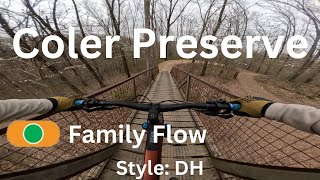
Great little jump line. Perfect for everyone all obstacles are rollable and safe. 2 wooden bridges that have rails on both sides. Awesome warm up jump line for all skill levels

Local Trail Association

Recent Activity on Trail

Past Week
  • 4 rides
  • 12 miles average
6 Months
  • 457 rides
  • 13 miles avg distance
All
  • 2,938 rides
  • Last: Jun 29, 2026
c1c2c3c4
January
February
March
April
May
June
July
August
September
October
November
December
update trails status or condition

Family Flow Trail Reports

Status:
on Jun 13, 2026
Dry
Avg: 4.6 (24 votes)
Your vote: 0

view (29,448)
close
3D
Trail Conditions
  • Unknown
  • Snow Groomed
  • Snow Packed
  • Snow Covered
  • Snow Cover Partial
  • Freeze/thaw Cycle
  • Icy
  • Prevalent Mud
  • Wet
  • Variable
  • Ideal
  • Dry
  • Very Dry
Trail Flow (Ridden Direction)
Trailforks scans users ridelogs to determine the most popular direction each trail is ridden. A good flowing trail network will have most trails flowing in a single direction according to their intension.
The colour categories are based on what percentage of riders are riding a trail in its intended direction.
  • > 96%
  • > 90%
  • > 80%
  • > 70%
  • > 50%
  • < 50%
  • bi-directional trail
  • no data
Trail Last Ridden
Trailforks scans ridelogs to determine the last time a trail was ridden.
  • < 2 days
  • < 1 week
  • < 2 weeks
  • < 1 month
  • < 6 months
  • > 6 months
Trail Ridden Direction
The intended direction a trail should be ridden.
  • Downhill Only
  • Downhill Primary
  • Both Directions
  • Uphill Primary
  • Uphill Only
  • One Direction
Contribute Details
Colors indicate trail is missing specified detail.
  • Description
  • Photos
  • Description & Photos
  • Videos
Trail Popularity ?
Trailforks scans ridelogs to determine which trails are ridden the most in the last 9 months. Trails are compared with nearby trails in the same city region with a possible 25 colour shades. Think of this as a heatmap, more rides = more kinetic energy = warmer colors.
  • most popular
  • popular
  • less popular
  • not popular
ATV/ORV/OHV Filter
Max Vehicle Width
inches
US Cell Coverage
Legend
cell carrier legend

Radar Time
Activity Recordings
Trailforks uses anonymized public activity data. ?
Activity Recordings
Trailforks uses anonymized public activity data. ?
Personal Heatmap
Activity Types
all / none
Options
2
Date range month
Winter Trails
Warning A routing network for winter maps does not exist. Selecting trails using the winter trails layer has been disabled.
Missing Trails
Most Popular
Least Popular
Trails are colored based on popularity. The more popular a trail is, the more red. Less popular trails trend towards green.
Jump Magnitude Heatmap
Heatmap of where riders jump on trails. Zoom in to see individual jumps, click circles to view jump details.
BC Backroad Status

Service Road Atlas is a free to use, community-driven service for viewing and creating reports on the numerous back-country service roads around B.C. and Alberta.

map legend
Slope Aspect
Direction the slope faces
Flat N NE E SE S SW W NW
Trails Deemphasized
Trails are shown in grey.
disable
Only show trails with no bike usage.
Enable
Suggested Layers
Based on selected activity type

    Save the current map location and zoom level as your default home location whenever this page is loaded.

    Save
        Directions to family-flow trailhead (36.379410, -94.238680)

        Photos

        2 more »
        36 |
        Feb 14, 2026 @ 10:28am
        Feb 14, 2026
        51 |
        Feb 14, 2026 @ 10:27am
        Feb 14, 2026
        243 |
        Apr 25, 2022 @ 7:50pm
        Apr 25, 2022
        238 |
        Mar 25, 2021 @ 8:27am
        Mar 25, 2021

        Videos

        10 more »
        Family Flow - Coler Preserve
        0:34 | 349 | May 23, 2024 , Bentonville
        Family Flow | Full Trail Coler Preserve...
        0:40 | 272 | Sep 16, 2023 , Bentonville
        FAMILY FLOW 11/02/2022 (Full VR on Youtube)
        2:09 | 222 | Nov 6, 2022 , Bentonville
        Family Flow | Full Trail, Mountain Biking...
        0:50 | 231 | Sep 30, 2022 , Bentonville

        Routes with this trail

        5.0 5 miles 569 ft 6
        This is just a portion of Coler that is designed to be good for new to intermediate riders.
        4.0 11 miles 1,129 ft 21 Loop Race
        Ozark Enduro Lite is funnest thing on two wheels. We aim to be inclusive and very beginner friendly. Our...
        7 miles 910 ft 18
        Welcome to the 2024 Ozark Enduro Lite Finale at Mtb Preserve

        6 Reviews & Comments


        We hope you've been enjoying Trailforks!

        Create a FREE account to view trail comments and much more.

        • By toddTF Pro Trailforks & contributors
        • #137854 - 6,817 views

        Frequently Asked Questions About Family Flow

        Where is Family Flow located?
        Family Flow is located in Coler Mountain Bike Preserve, Bentonville, Arkansas, United States. It is part of the Coler Mountain Bike Preserve trail network. The trailhead is located at coordinates 36.37941, -94.23868.
        How hard is Family Flow?
        Family Flow is rated as Green difficulty. The average grade is 3.9%.
        What is the elevation gain for Family Flow?
        Family Flow has 13 ft of elevation gain. The trail has 89 ft of elevation descent. The elevation ranges from 1,164 ft to 1,241 ft.
        Is Family Flow a point to point trail?
        Yes, Family Flow is a point to point trail. The direction is Downhill Only. The trail type is singletrack.

        Hit the Trail

        Open in App

        Get this trail on your phone instantly.
        open trail in app

        Download Trail

        Save to wishlist, Garmin & download.
        save the trail

        Find Related Routes

        Find routes and users activities that include this trail.
        find routes for this trail

        You must enter a description before submitting.