more stats
2,060 ft
Distance
-318 ft
Descent
00:02:18
Avg time
-318 ft
Altitude change
913 ft
Altitude min
1,231 ft
Altitude max
1,231 ft
Altitude start
912 ft
Altitude end
-15.4%
Grade
-33.9%
Grade max
-4.2%
Grade min
2,060 ft
Distance down
00:02:18
Avg time

Fancy Feast Details

  • Activities
    • Mountain Bike
  • Riding Area
    Highland Mountain Bike Park
    Northfield, New Hampshire
  • Difficulty Rating
  • Voted Difficulty
    Blue (2 votes)
  • Local Popularity
    70 in Mountain Biking
  • Global Ranking
    #748 in Mountain Biking
  • Trail Type
    Singletrack
  • Bike Type
    DH, AM
  • Direction
    Downhill Only
    Popular Direction Shown
  • Physical Rating
    Moderate
  • Trail Visibility
    Always easy to follow
  • eBike Allowed
  • TTFs on Trail
    Drop, Rock Face, Wallride
  • Ride in Rain
    Yes
  • Land Owner

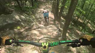
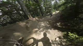
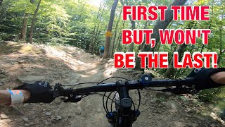
This trail is a super berm fest roller coaster. The berms send you sideways over and over and then throw in some rock drop options, and this trail is loads of fun. I parallels the Cat's Paw trail in several places and provides some options to combine the the trails.

Bike Park

Traditionally Indigenous Territory

Recent Activity on Trail

Past Week
  • 12 rides
  • 14 miles average
6 Months
  • 134 rides
  • 16 miles avg distance
All
  • 1,871 rides
  • Last: Jun 20, 2026
c1c2c3c4
January
February
March
April
May
June
July
August
September
October
November
December
Status:
on Jun 4, 2026
Ideal
Avg: 4.23 (29 votes)
Your vote: 0

view (19,080)
close
3D
Trail Conditions
  • Unknown
  • Snow Groomed
  • Snow Packed
  • Snow Covered
  • Snow Cover Partial
  • Freeze/thaw Cycle
  • Icy
  • Prevalent Mud
  • Wet
  • Variable
  • Ideal
  • Dry
  • Very Dry
Trail Flow (Ridden Direction)
Trailforks scans users ridelogs to determine the most popular direction each trail is ridden. A good flowing trail network will have most trails flowing in a single direction according to their intension.
The colour categories are based on what percentage of riders are riding a trail in its intended direction.
  • > 96%
  • > 90%
  • > 80%
  • > 70%
  • > 50%
  • < 50%
  • bi-directional trail
  • no data
Trail Last Ridden
Trailforks scans ridelogs to determine the last time a trail was ridden.
  • < 2 days
  • < 1 week
  • < 2 weeks
  • < 1 month
  • < 6 months
  • > 6 months
Trail Ridden Direction
The intended direction a trail should be ridden.
  • Downhill Only
  • Downhill Primary
  • Both Directions
  • Uphill Primary
  • Uphill Only
  • One Direction
Contribute Details
Colors indicate trail is missing specified detail.
  • Description
  • Photos
  • Description & Photos
  • Videos
Trail Popularity ?
Trailforks scans ridelogs to determine which trails are ridden the most in the last 9 months. Trails are compared with nearby trails in the same city region with a possible 25 colour shades. Think of this as a heatmap, more rides = more kinetic energy = warmer colors.
  • most popular
  • popular
  • less popular
  • not popular
ATV/ORV/OHV Filter
Max Vehicle Width
inches
US Cell Coverage
Legend
cell carrier legend

Radar Time
Activity Recordings
Trailforks uses anonymized public activity data. ?
Activity Recordings
Trailforks uses anonymized public activity data. ?
Personal Heatmap
Activity Types
all / none
Options
2
Date range month
Winter Trails
Warning A routing network for winter maps does not exist. Selecting trails using the winter trails layer has been disabled.
Missing Trails
Most Popular
Least Popular
Trails are colored based on popularity. The more popular a trail is, the more red. Less popular trails trend towards green.
Jump Magnitude Heatmap
Heatmap of where riders jump on trails. Zoom in to see individual jumps, click circles to view jump details.
BC Backroad Status

Service Road Atlas is a free to use, community-driven service for viewing and creating reports on the numerous back-country service roads around B.C. and Alberta.

map legend
Slope Aspect
Direction the slope faces
Flat N NE E SE S SW W NW
Trails Deemphasized
Trails are shown in grey.
disable
Only show trails with no bike usage.
Enable
Suggested Layers
Based on selected activity type

    Save the current map location and zoom level as your default home location whenever this page is loaded.

    Save
        Directions to fancy-feast trailhead (43.399810, -71.553240)

        Photos

        7 more »
        235 |
        Jun 6, 2016 @ 9:04am
        Jun 6, 2016
        319 |
        Jul 7, 2014 @ 7:49pm
        Jul 7, 2014
        375 |
        Sep 21, 2016 @ 3:46am
        Sep 21, 2016
        223 |
        Jun 6, 2016 @ 9:01am
        Jun 6, 2016

        Videos

        12 more »
        FULL PULL Down 'Fancy Feast' at Highland...
        3:49 | 55 | Sep 6, 2025 , Northfield
        Fancy Feast - Highland Bike Park
        4:06 | 94 | Jul 19, 2024 , Northfield
        Fancy Feast
        3:40 | 138 | Aug 7, 2023 , Northfield
        Downhill mountain biking at Highland - Fancy...
        4:36 | 361 | Oct 13, 2022 , Northfield

        Reviews / Comments

        No reviews yet, be the first to write a review or ask a question.
        Use trail reports to comment on trail conditions.


        We hope you've been enjoying Trailforks!

        Create a FREE account to view trail comments and much more.

        • By benmob1898 & contributors
        • #5046 - 4,370 views

        Frequently Asked Questions About Fancy Feast

        Where is Fancy Feast located?
        Fancy Feast is located in Highland Mountain Bike Park, Northfield, New Hampshire, United States. It is part of the Highland Mountain Bike Park trail network. The trailhead is located at coordinates 43.39981, -71.55324.
        How hard is Fancy Feast?
        Fancy Feast is rated as Blue difficulty. The physical rating is Moderate. The average grade is 15.4%.
        What is the elevation gain for Fancy Feast?
        The trail has 97 m of elevation descent. The elevation ranges from 278 m to 375 m.
        Is Fancy Feast a point to point trail?
        Yes, Fancy Feast is a point to point trail. The direction is Downhill Only. The trail type is singletrack.

        Hit the Trail

        Open in App

        Get this trail on your phone instantly.
        open trail in app

        Download Trail

        Save to wishlist, Garmin & download.
        save the trail

        Find Related Routes

        Find routes and users activities that include this trail.
        find routes for this trail

        You must enter a description before submitting.