more stats
3.2 miles
Distance
1,123 ft
Climb
-5 ft
Descent
00:49:23
Avg time
1,118 ft
Altitude change
4,948 ft
Altitude min
6,066 ft
Altitude max
4,948 ft
Altitude start
6,066 ft
Altitude end
6.6%
Grade
-9.9%
Grade max
37.5%
Grade min
3 miles
Distance climb
358 ft
Distance down
1,063 ft
Distance flat
00:49:23
Avg time

Farewell Details

  • Activities
    • Mountain Bike
    • Hike
    • Trail Running
  • Riding Area
    Phil's
    Bend, Oregon
  • Difficulty Rating
  • Voted Difficulty
    Black Diamond (3 votes)
  • Local Popularity
    80 in Mountain Biking [+]
    • 90 in Trail Running
    • 85 in Hiking
  • Global Ranking
    #72915 in Mountain Biking [+]
    • #43230 in Trail Running
    • #65710 in Hiking
  • Hiking SAC Scale
    T2 Mountain Hiking
  • Trail Type
    Singletrack
  • Bike Type
    DH, AM, XC
  • Direction
    Both Directions
    Popular In Reverse
  • Climb Difficulty
    Blue
  • Physical Rating
    Hard
  • Trail Visibility
    Always easy to follow
  • Dogs Allowed
    Yes
  • TTFs on Trail
    Rock Garden
  • Land Owner
    USFS - Deschutes Ranger District

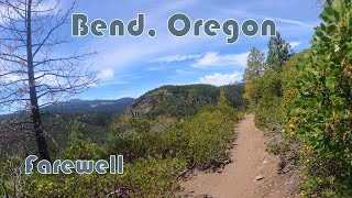
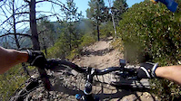
As a climb, Farewell has a stiff beginning of tight switchbacks. As you quickly gain elevation, the climbing grade decreases and even offers a few great views of nearby mountains.

Trail Supporters

  • USFS
    Land Manager
Local Trail Association

Recent Activity on Trail

Past Week
  • 10 rides
  • 17 miles average
6 Months
  • 76 rides
  • 16 miles avg distance
All
  • 789 rides
  • Last: Jun 20, 2026
c1c2c3c4
January
February
March
April
May
June
July
August
September
October
November
December
update trails status or condition

Farewell Trail Reports

statusdatedescription
May 11, 2026 @ 12:03pm (America/Los_Angeles)
May 11, 2026
Apr 13, 2026 @ 9:40pm (America/Los_Angeles)
Apr 13, 2026
No snow on the trail. Two fallen trees. Rain has made the trails primo.
Apr 4, 2026 @ 11:48am (America/Vancouver)
Apr 4, 2026
Two trees down. Short rideable mucky snow until below the recent forest work.
Nov 22, 2025 @ 8:51pm (America/Los_Angeles)
Nov 22, 2025
Oct 17, 2025 @ 5:27pm (America/Los_Angeles)
Oct 17, 2025
Some puddles and mud at the top, otherwise it's pretty dry as you descend. The big problem is the access to this trail: the top of North Fork,...
more »
Status:
on May 11, 2026
Dry
Avg: 4.29 (19 votes)
Your vote: 0

view (4,058)
close
3D
Trail Conditions
  • Unknown
  • Snow Groomed
  • Snow Packed
  • Snow Covered
  • Snow Cover Partial
  • Freeze/thaw Cycle
  • Icy
  • Prevalent Mud
  • Wet
  • Variable
  • Ideal
  • Dry
  • Very Dry
Trail Flow (Ridden Direction)
Trailforks scans users ridelogs to determine the most popular direction each trail is ridden. A good flowing trail network will have most trails flowing in a single direction according to their intension.
The colour categories are based on what percentage of riders are riding a trail in its intended direction.
  • > 96%
  • > 90%
  • > 80%
  • > 70%
  • > 50%
  • < 50%
  • bi-directional trail
  • no data
Trail Last Ridden
Trailforks scans ridelogs to determine the last time a trail was ridden.
  • < 2 days
  • < 1 week
  • < 2 weeks
  • < 1 month
  • < 6 months
  • > 6 months
Trail Ridden Direction
The intended direction a trail should be ridden.
  • Downhill Only
  • Downhill Primary
  • Both Directions
  • Uphill Primary
  • Uphill Only
  • One Direction
Contribute Details
Colors indicate trail is missing specified detail.
  • Description
  • Photos
  • Description & Photos
  • Videos
Trail Popularity ?
Trailforks scans ridelogs to determine which trails are ridden the most in the last 9 months. Trails are compared with nearby trails in the same city region with a possible 25 colour shades. Think of this as a heatmap, more rides = more kinetic energy = warmer colors.
  • most popular
  • popular
  • less popular
  • not popular
ATV/ORV/OHV Filter
Max Vehicle Width
inches
US Cell Coverage
Legend
cell carrier legend

Radar Time
Activity Recordings
Trailforks uses anonymized public activity data. ?
Activity Recordings
Trailforks uses anonymized public activity data. ?
Personal Heatmap
Activity Types
all / none
Options
2
Date range month
Winter Trails
Warning A routing network for winter maps does not exist. Selecting trails using the winter trails layer has been disabled.
Missing Trails
Most Popular
Least Popular
Trails are colored based on popularity. The more popular a trail is, the more red. Less popular trails trend towards green.
Jump Magnitude Heatmap
Heatmap of where riders jump on trails. Zoom in to see individual jumps, click circles to view jump details.
BC Backroad Status

Service Road Atlas is a free to use, community-driven service for viewing and creating reports on the numerous back-country service roads around B.C. and Alberta.

map legend
Slope Aspect
Direction the slope faces
Flat N NE E SE S SW W NW
Trails Deemphasized
Trails are shown in grey.
disable
Only show trails with no bike usage.
Enable
Suggested Layers
Based on selected activity type

    Save the current map location and zoom level as your default home location whenever this page is loaded.

    Save
        Directions to farewell trailhead (44.031720, -121.564670)

        Photos

        18 more »
        81 |
        Oct 8, 2025 @ 6:41pm
        Oct 8, 2025
        91 |
        Sep 22, 2025 @ 6:10pm
        Sep 22, 2025
        245 |
        Aug 15, 2022 @ 8:51am
        Aug 15, 2022
        605 |
        Feb 12, 2021 @ 11:59am
        Feb 12, 2021

        Videos

        4 more »
        youtuber Best Trail In Bend Oregon? (Not Phil’s Trail)
        12:00 | 880 | Dec 27, 2020 , Bend
        This Trail BLEW OUR MINDS | Waterfalls,...
        31:59 | 31 | Jan 21, 2026 , Bend
        MTB Bend, Oregon - Farewell (2025)
        18:09 | 109 | Aug 13, 2025 , Bend
        A quick blast down Farewell Trail
        2:31 | 734 | Oct 17, 2012 , Bend

        Routes with this trail

        5.0 9 miles 1,406 ft 2 Loop
        tour around tumble falls up north fork down farewell
        28 miles 1,716 ft 7 Shuttled
        Optional shuttle ride from Dutchman Sno Park. Start with a beautiful backcountry traverse on...
        41 miles 3,790 ft 6 Loop
        Ride from Bend's West-side. I start near Victorian Cafe. It rides up to Tree Farm and connects to the...

        Trail Products

        6 Reviews & Comments


        We hope you've been enjoying Trailforks!

        Create a FREE account to view trail comments and much more.

        • By rockystumpyTF Pro & contributors
        • #62279 - 6,178 views

        Frequently Asked Questions About Farewell

        Where is Farewell located?
        Farewell is located in Phil's, Bend, Oregon, United States. It is part of the Phil's trail network. The trailhead is located at coordinates 44.03172, -121.56467.
        How hard is Farewell?
        Farewell is rated as Black Diamond difficulty. The physical rating is Hard. The average grade is 6.6%. The climb difficulty is rated Blue.
        What is the elevation gain for Farewell?
        Farewell has 342 m of elevation gain. The trail has 2 m of elevation descent. The elevation ranges from 1,508 m to 1,849 m.
        Is Farewell a point to point trail?
        Farewell is not a point to point trail. The direction is Both Directions. The trail type is singletrack.

        Hit the Trail

        Open in App

        Get this trail on your phone instantly.
        open trail in app

        Download Trail

        Save to wishlist, Garmin & download.
        save the trail

        Find Related Routes

        Find routes and users activities that include this trail.
        find routes for this trail

        You must enter a description before submitting.