more stats
1,499 ft
Distance
-111 ft
Descent
525 ft
High Point
-111 ft
Altitude change
414 ft
Altitude min
525 ft
Altitude start
413 ft
Altitude end
-7.4%
Grade
-19.1%
Grade max
-0.8%
Grade min
1,457 ft
Distance down
39 ft
Distance flat

Fast & The Curious Details

  • Activities
    • Mountain Bike
    • E-Bike
    • Adaptive Bike
  • Riding Area
    MTB Tehaleh
    Bonney Lake, Washington
  • Difficulty Rating
  • Local Popularity
    55 in Mountain Biking [+]
    • 65 in E-Biking
  • Trail Type
    Mixed
  • Bike Type
    DH, AM, XC, DJ, Adaptive MTB
  • Direction
    Downhill Only[+]
    Popular Direction Shown
    • Downhill Only for Adaptive Biking
  • Trail Visibility
    Always easy to follow
  • eBike Allowed
    Yes up to Class 1
  • TTFs on Trail
    Jump
  • Ride in Rain
    Yes
  • Year Opened
    2024

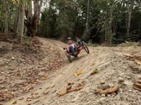
Whether you're fast or just curious this dual slalom lets you test your skills against your friends.

This trail has a little of everything, and it is all rollable.

Adaptive Bike Info
aMTB Blue Rating: Intermediate features and steeper terrain.

Width: 48" Ave. / 44" Min.
Camber: to 8%
Slope: Down to 19% / Up n/a

Adaptive Evaluation Form

View PDF

Local Trail Association
Traditionally Indigenous Territory

Recent Activity on Trail

Past Week
  • 5 rides
  • 8 miles average
6 Months
  • 75 rides
  • 9 miles avg distance
All
  • 287 rides
  • Last: Jun 17, 2026
c1c2c3c4
January
February
March
April
May
June
July
August
September
October
November
December
update trails status or condition

Fast & The Curious Trail Reports

Status:
on May 27, 2026
Dry
Avg: 4.32 (3 votes)
Your vote: 0

view (1,450)
close
3D
Trail Conditions
  • Unknown
  • Snow Groomed
  • Snow Packed
  • Snow Covered
  • Snow Cover Partial
  • Freeze/thaw Cycle
  • Icy
  • Prevalent Mud
  • Wet
  • Variable
  • Ideal
  • Dry
  • Very Dry
Trail Flow (Ridden Direction)
Trailforks scans users ridelogs to determine the most popular direction each trail is ridden. A good flowing trail network will have most trails flowing in a single direction according to their intension.
The colour categories are based on what percentage of riders are riding a trail in its intended direction.
  • > 96%
  • > 90%
  • > 80%
  • > 70%
  • > 50%
  • < 50%
  • bi-directional trail
  • no data
Trail Last Ridden
Trailforks scans ridelogs to determine the last time a trail was ridden.
  • < 2 days
  • < 1 week
  • < 2 weeks
  • < 1 month
  • < 6 months
  • > 6 months
Trail Ridden Direction
The intended direction a trail should be ridden.
  • Downhill Only
  • Downhill Primary
  • Both Directions
  • Uphill Primary
  • Uphill Only
  • One Direction
Contribute Details
Colors indicate trail is missing specified detail.
  • Description
  • Photos
  • Description & Photos
  • Videos
Trail Popularity ?
Trailforks scans ridelogs to determine which trails are ridden the most in the last 9 months. Trails are compared with nearby trails in the same city region with a possible 25 colour shades. Think of this as a heatmap, more rides = more kinetic energy = warmer colors.
  • most popular
  • popular
  • less popular
  • not popular
ATV/ORV/OHV Filter
Max Vehicle Width
inches
US Cell Coverage
Legend
cell carrier legend

Radar Time
Activity Recordings
Trailforks uses anonymized public activity data. ?
Activity Recordings
Trailforks uses anonymized public activity data. ?
Personal Heatmap
Activity Types
all / none
Options
2
Date range month
Winter Trails
Warning A routing network for winter maps does not exist. Selecting trails using the winter trails layer has been disabled.
Missing Trails
Most Popular
Least Popular
Trails are colored based on popularity. The more popular a trail is, the more red. Less popular trails trend towards green.
Jump Magnitude Heatmap
Heatmap of where riders jump on trails. Zoom in to see individual jumps, click circles to view jump details.
BC Backroad Status

Service Road Atlas is a free to use, community-driven service for viewing and creating reports on the numerous back-country service roads around B.C. and Alberta.

map legend
Slope Aspect
Direction the slope faces
Flat N NE E SE S SW W NW
Trails Deemphasized
Trails are shown in grey.
disable
Only show trails with no bike usage.
Enable
Suggested Layers
Based on selected activity type

    Save the current map location and zoom level as your default home location whenever this page is loaded.

    Save
        Directions to fast--the-curious trailhead (47.113350, -122.210960)

        Photos

        3 more »
        91 |
        May 16, 2024 @ 7:17pm
        May 16, 2024
        89 |
        May 16, 2024 @ 7:15pm
        May 16, 2024
        59 |
        Apr 16, 2024 @ 2:30pm
        Apr 16, 2024
        47 |
        Nov 13, 2025 @ 3:11pm
        Nov 13, 2025

        Videos

        2 more »
        youtuber Tehaleh | Another New Trail System in Washington!
        19:56 | 60 | Jun 24, 2024 , Bonney Lake
        Fast and Curious
        3:13 | 57 | Jun 19, 2024 , Bonney Lake

        1 Review & Comments


        We hope you've been enjoying Trailforks!

        Create a FREE account to view trail comments and much more.

        Frequently Asked Questions About Fast & The Curious

        Where is Fast & The Curious located?
        Fast & The Curious is located in MTB Tehaleh, Bonney Lake, Washington, United States. It is part of the MTB Tehaleh trail network. The trailhead is located at coordinates 47.11335, -122.21096.
        How hard is Fast & The Curious?
        Fast & The Curious is rated as Blue difficulty. The average grade is 7.4%.
        What is the elevation gain for Fast & The Curious?
        The trail has 111 ft of elevation descent. The elevation ranges from 414 ft to 525 ft.
        Is Fast & The Curious a point to point trail?
        Yes, Fast & The Curious is a point to point trail. The direction is Downhill Only. The trail type is mixed.

        Hit the Trail

        Open in App

        Get this trail on your phone instantly.
        open trail in app

        Download Trail

        Save to wishlist, Garmin & download.
        save the trail

        Find Related Routes

        Find routes and users activities that include this trail.
        find routes for this trail

        You must enter a description before submitting.