more stats
3,471 ft
Distance
40 ft
Climb
-310 ft
Descent
00:10:02
Avg time
-271 ft
Altitude change
7,503 ft
Altitude min
7,789 ft
Altitude max
7,789 ft
Altitude start
7,520 ft
Altitude end
-7.8%
Grade
-32%
Grade max
16.3%
Grade min
535 ft
Distance climb
2,559 ft
Distance down
377 ft
Distance flat
00:10:02
Avg time

Ferndell Trail Details

  • Activities
    • Mountain Bike
    • Horse
    • Hike
    • Trail Running
  • Riding Area
  • Ref Number
    #204
  • Difficulty Rating
  • Local Popularity
    95 in Mountain Biking [+]
    • 5 in Trail Running
    • 5 in Hiking
    • 5 in Horseback
  • Global Ranking
    #58834 in Mountain Biking [+]
    • #215833 in Trail Running
    • #223824 in Hiking
  • Hiking SAC Scale
    T1 Hiking
  • Trail Type
    Singletrack
  • Bike Type
    DH, AM, XC
  • Direction
    Both Directions
    Popular In Reverse
  • Climb Difficulty
    Blue
  • Physical Rating
    Moderate
  • Trail Visibility
    Always easy to follow
  • Family Friendly
    Yes
  • Dogs Allowed
    Yes
  • eBike Allowed
  • Land Owner
    https://www.fs.usda.gov/recarea/tonto/specialplaces/recarea?recid=35343&actid=37

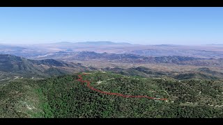
This short fast and fun trail on Pinal Peak is a great way to add 300ft of elevation loss to your six shooter ride with only a slight climb as you near Ferndale lot and Sixshooter trail.

Some people like to run laps on it when they camp up top.

Trail Supporters
Local Trail Association
Traditionally Indigenous Territory

Recent Activity on Trail

Past Week
  • 3 rides
  • 13 miles average
6 Months
  • 12 rides
  • 15 miles avg distance
All
  • 62 rides
  • Last: Jun 26, 2026
c1c2c3c4
January
February
March
April
May
June
July
August
September
October
November
December
update trails status or condition

Ferndell Trail Trail Reports

statusdatedescription
Mar 6, 2026 @ 5:18pm (America/Phoenix)
Mar 6, 2026
reporter Trees have been cleared on ferndale to sixshooter and expect it to be rough until we can get in to clean up the tread. Also sixer just a...
Jan 17, 2026 @ 4:52pm (America/Phoenix)
Jan 17, 2026
reporter combination of trees down and lots of snow and ice
Jan 6, 2026 @ 12:59pm (America/Phoenix)
Jan 6, 2026
10 trees down. Water damage.
Dec 13, 2025 @ 8:12pm (America/Phoenix)
Dec 13, 2025
reporter snow is gone for now. A lil rough around the edges but still great
Nov 21, 2025 @ 7:06pm (America/Phoenix)
Nov 21, 2025
reporter snow has arrived on the peak.
more »
Status:
on Mar 6, 2026
Variable
Avg: 4.11 (4 votes)
Your vote: 0

view (228)
close
3D
Trail Conditions
  • Unknown
  • Snow Groomed
  • Snow Packed
  • Snow Covered
  • Snow Cover Partial
  • Freeze/thaw Cycle
  • Icy
  • Prevalent Mud
  • Wet
  • Variable
  • Ideal
  • Dry
  • Very Dry
Trail Flow (Ridden Direction)
Trailforks scans users ridelogs to determine the most popular direction each trail is ridden. A good flowing trail network will have most trails flowing in a single direction according to their intension.
The colour categories are based on what percentage of riders are riding a trail in its intended direction.
  • > 96%
  • > 90%
  • > 80%
  • > 70%
  • > 50%
  • < 50%
  • bi-directional trail
  • no data
Trail Last Ridden
Trailforks scans ridelogs to determine the last time a trail was ridden.
  • < 2 days
  • < 1 week
  • < 2 weeks
  • < 1 month
  • < 6 months
  • > 6 months
Trail Ridden Direction
The intended direction a trail should be ridden.
  • Downhill Only
  • Downhill Primary
  • Both Directions
  • Uphill Primary
  • Uphill Only
  • One Direction
Contribute Details
Colors indicate trail is missing specified detail.
  • Description
  • Photos
  • Description & Photos
  • Videos
Trail Popularity ?
Trailforks scans ridelogs to determine which trails are ridden the most in the last 9 months. Trails are compared with nearby trails in the same city region with a possible 25 colour shades. Think of this as a heatmap, more rides = more kinetic energy = warmer colors.
  • most popular
  • popular
  • less popular
  • not popular
ATV/ORV/OHV Filter
Max Vehicle Width
inches
US Cell Coverage
Legend
cell carrier legend

Radar Time
Activity Recordings
Trailforks uses anonymized public activity data. ?
Activity Recordings
Trailforks uses anonymized public activity data. ?
Personal Heatmap
Activity Types
all / none
Options
2
Date range month
Winter Trails
Warning A routing network for winter maps does not exist. Selecting trails using the winter trails layer has been disabled.
Missing Trails
Most Popular
Least Popular
Trails are colored based on popularity. The more popular a trail is, the more red. Less popular trails trend towards green.
Jump Magnitude Heatmap
Heatmap of where riders jump on trails. Zoom in to see individual jumps, click circles to view jump details.
BC Backroad Status

Service Road Atlas is a free to use, community-driven service for viewing and creating reports on the numerous back-country service roads around B.C. and Alberta.

map legend
Slope Aspect
Direction the slope faces
Flat N NE E SE S SW W NW
Trails Deemphasized
Trails are shown in grey.
disable
Only show trails with no bike usage.
Enable
Suggested Layers
Based on selected activity type

    Save the current map location and zoom level as your default home location whenever this page is loaded.

    Save
        Directions to ferndell-trail trailhead (33.281960, -110.819980)

        Photos

        9 more »
        28 |
        May 8, 2025 @ 6:25pm
        May 8, 2025
        21 |
        May 8, 2025 @ 6:25pm
        May 8, 2025
        26 |
        May 8, 2025 @ 6:25pm
        May 8, 2025
        49 |
        Jul 25, 2022 @ 2:26pm
        Jul 25, 2022

        Videos

        1 more »
        Ferndell
        0:54 | 298 | Aug 20, 2020 , Globe

        Routes with this trail

        5.0 7 miles 279 ft 4 Shuttled
        This is the longest single track route on the mountain! Ferndale is fun and flowy. Top of Six Shooter is a...
        7 miles 366 ft 3 Shuttled
        If you are looking for the most miles and full Pinal Mountain Experience then this is the route for you....

        Reviews / Comments

        No reviews yet, be the first to write a review or ask a question.
        Use trail reports to comment on trail conditions.


        We hope you've been enjoying Trailforks!

        Create a FREE account to view trail comments and much more.

        • By schillingsworthTF Pro TRAILFORKS HTA & contributors
        • #19960 - 2,953 views

        Frequently Asked Questions About Ferndell Trail

        Where is Ferndell Trail located?
        Ferndell Trail is located in Pinal Mountain Trail System, Globe, Arizona, United States. It is part of the Pinal Mountain Trail System trail network. The trailhead is located at coordinates 33.28196, -110.81998.
        How hard is Ferndell Trail?
        Ferndell Trail is rated as Blue difficulty. The physical rating is Moderate. The average grade is 7.8%. The climb difficulty is rated Blue.
        What is the elevation gain for Ferndell Trail?
        Ferndell Trail has 40 ft of elevation gain. The trail has 310 ft of elevation descent. The elevation ranges from 7,503 ft to 7,789 ft.
        Is Ferndell Trail a point to point trail?
        Ferndell Trail is not a point to point trail. The direction is Both Directions. The trail type is singletrack.

        Hit the Trail

        Open in App

        Get this trail on your phone instantly.
        open trail in app

        Download Trail

        Save to wishlist, Garmin & download.
        save the trail

        Find Related Routes

        Find routes and users activities that include this trail.
        find routes for this trail

        You must enter a description before submitting.