more stats
413 ft
Distance
8 ft
Climb
00:00:35
Avg time
9 ft
Altitude change
120 ft
Altitude min
130 ft
Altitude max
120 ft
Altitude start
131 ft
Altitude end
2.2%
Grade
4.5%
Grade min
266 ft
Distance climb
148 ft
Distance flat
00:00:35
Avg time

Ferny Details

  • Activities
    • Mountain Bike
    • E-Bike
    • Hike
    • Trail Running
  • Riding Area
    Coquitlam River
    Coquitlam, British Columbia
  • Difficulty Rating
  • Local Popularity
    55 in Mountain Biking [+]
    • 40 in E-Biking
    • 65 in Trail Running
    • 5 in Hiking
  • Global Ranking
    #98156 in Mountain Biking [+]
    • #183643 in E-Biking
    • #82955 in Trail Running
    • #229511 in Hiking
  • Hiking SAC Scale
    T1 Hiking
  • Trail Type
    Singletrack
  • Direction
    Both Directions
  • Climb Difficulty
    Blue
  • Physical Rating
    Easy
  • eBike Allowed
    Yes up to Class 1

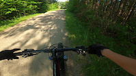
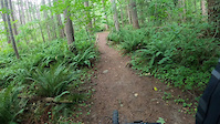
Quick flowy trail through an open section of forest with lots of sword ferns. Runs close to the west side of the Coquitlam River, and is used by many to access the nearby beach spot.

This trail is unsanctioned.

Trail Supporters

Recent Activity on Trail

Past Week
  • 0 rides
  •  
6 Months
  • 1 rides
  • 58 miles avg distance
All
  • 61 rides
  • Last: Jun 6, 2026
c1c2c3c4
January
February
March
April
May
June
July
August
September
October
November
December
update trails status or condition

Ferny Trail Reports

statusdatedescription
Aug 29, 2025 @ 5:17pm
Aug 29, 2025
Cleared off all the branches and ferns in the way of the mid section
Aug 25, 2025 @ 5:29pm
Aug 25, 2025
Middle section super overgrown almost impassable
Nov 1, 2023 @ 4:40pm
Nov 1, 2023
Oct 19, 2023 @ 5:18pm
Oct 19, 2023
Sep 15, 2023 @ 6:27pm
Sep 15, 2023
more »
Status:
on Aug 29, 2025
Dry
Avg: 3.98 (1 votes)
Your vote: 0

view (474)
close
3D
Trail Conditions
  • Unknown
  • Snow Groomed
  • Snow Packed
  • Snow Covered
  • Snow Cover Partial
  • Freeze/thaw Cycle
  • Icy
  • Prevalent Mud
  • Wet
  • Variable
  • Ideal
  • Dry
  • Very Dry
Trail Flow (Ridden Direction)
Trailforks scans users ridelogs to determine the most popular direction each trail is ridden. A good flowing trail network will have most trails flowing in a single direction according to their intension.
The colour categories are based on what percentage of riders are riding a trail in its intended direction.
  • > 96%
  • > 90%
  • > 80%
  • > 70%
  • > 50%
  • < 50%
  • bi-directional trail
  • no data
Trail Last Ridden
Trailforks scans ridelogs to determine the last time a trail was ridden.
  • < 2 days
  • < 1 week
  • < 2 weeks
  • < 1 month
  • < 6 months
  • > 6 months
Trail Ridden Direction
The intended direction a trail should be ridden.
  • Downhill Only
  • Downhill Primary
  • Both Directions
  • Uphill Primary
  • Uphill Only
  • One Direction
Contribute Details
Colors indicate trail is missing specified detail.
  • Description
  • Photos
  • Description & Photos
  • Videos
Trail Popularity ?
Trailforks scans ridelogs to determine which trails are ridden the most in the last 9 months. Trails are compared with nearby trails in the same city region with a possible 25 colour shades. Think of this as a heatmap, more rides = more kinetic energy = warmer colors.
  • most popular
  • popular
  • less popular
  • not popular
ATV/ORV/OHV Filter
Max Vehicle Width
inches
US Cell Coverage
Legend
cell carrier legend

Radar Time
Activity Recordings
Trailforks uses anonymized public activity data. ?
Activity Recordings
Trailforks uses anonymized public activity data. ?
Personal Heatmap
Activity Types
all / none
Options
2
Date range month
Winter Trails
Warning A routing network for winter maps does not exist. Selecting trails using the winter trails layer has been disabled.
Missing Trails
Most Popular
Least Popular
Trails are colored based on popularity. The more popular a trail is, the more red. Less popular trails trend towards green.
Jump Magnitude Heatmap
Heatmap of where riders jump on trails. Zoom in to see individual jumps, click circles to view jump details.
BC Backroad Status

Service Road Atlas is a free to use, community-driven service for viewing and creating reports on the numerous back-country service roads around B.C. and Alberta.

map legend
Slope Aspect
Direction the slope faces
Flat N NE E SE S SW W NW
Trails Deemphasized
Trails are shown in grey.
disable
Only show trails with no bike usage.
Enable
Suggested Layers
Based on selected activity type

    Save the current map location and zoom level as your default home location whenever this page is loaded.

    Save
        Directions to ferny trailhead (49.293000, -122.773880)

        Photos

        0 more »
        32 |
        Aug 29, 2025 @ 5:37pm
        Aug 29, 2025
        27 |
        Aug 29, 2025 @ 5:36pm
        Aug 29, 2025
        41 |
        Aug 29, 2025 @ 5:17pm
        Aug 29, 2025
        30 |
        Aug 25, 2025 @ 5:29pm
        Aug 25, 2025

        Videos

        2 more »
        0:31 | 10 | May 24, 2023 , Coquitlam
        0:30 | 9 | Aug 14, 2022 , Coquitlam

        Reviews / Comments

        No reviews yet, be the first to write a review or ask a question.
        Use trail reports to comment on trail conditions.


        We hope you've been enjoying Trailforks!

        Create a FREE account to view trail comments and much more.

        • #324343 - 512 views

        Frequently Asked Questions About Ferny

        Where is Ferny located?
        Ferny is located in Coquitlam River, Coquitlam, British Columbia, Canada. It is part of the Coquitlam River trail network. The trailhead is located at coordinates 49.293, -122.77388.
        How hard is Ferny?
        Ferny is rated as Green difficulty. The physical rating is Easy. The average grade is 2.2%. The climb difficulty is rated Blue.
        What is the elevation gain for Ferny?
        Ferny has 8 ft of elevation gain. The elevation ranges from 120 ft to 130 ft.
        Is Ferny a point to point trail?
        Ferny is not a point to point trail. The direction is Both Directions. The trail type is singletrack.

        Hit the Trail

        Open in App

        Get this trail on your phone instantly.
        open trail in app

        Download Trail

        Save to wishlist, Garmin & download.
        save the trail

        Find Related Routes

        Find routes and users activities that include this trail.
        find routes for this trail

        You must enter a description before submitting.