more stats
6.0 miles
Distance
507 ft
Climb
-402 ft
Descent
00:55:18
Avg time
103 ft
Altitude change
5,192 ft
Altitude min
5,448 ft
Altitude max
5,192 ft
Altitude start
5,295 ft
Altitude end
0.3%
Grade
-18.5%
Grade max
20%
Grade min
3 miles
Distance climb
2 miles
Distance down
1 mile
Distance flat
00:55:18
Avg time

Festicle Details

  • Activities
    • Mountain Bike
    • Hike
    • Trail Running
  • Riding Area
    McCoy Flats
    Vernal, Utah
  • Difficulty Rating
  • Local Popularity
    95 in Mountain Biking [+]
    • 100 in Trail Running
    • 75 in Hiking
  • Global Ranking
    #46891 in Mountain Biking [+]
    • #765 in Trail Running
    • #58798 in Hiking
  • Trail Type
    Singletrack
  • Direction
    Both Directions
    Popular Direction Shown
  • Dogs Allowed
    Yes

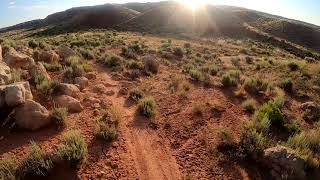
Rode it CCW, still good in that direction aside from a couple brief steep hikes. Some sandy parts, trail can be hard to follow a couple times; keep eyes peeled for path marked by small rocks. Great rocky techie sections, some cliff-like exposure. Rustic, old school feel. Convenient to primitive/rough camping area in the western side of the trail system. Solid adventure

Local Trail Association
Traditionally Indigenous Territory

Recent Activity on Trail

Past Week
  • 0 rides
  •  
6 Months
  • 11 rides
  • 11 miles avg distance
All
  • 78 rides
  • Last: Jun 13, 2026
c1c2c3c4
January
February
March
April
May
June
July
August
September
October
November
December
update trails status or condition

Festicle Trail Reports

statusdatedescription
Dec 15, 2025 @ 3:57pm (America/Denver)
Dec 15, 2025
reporter All trails at McCoy are still dry and riding well, despite some damage from fall rains. Will update if we ever get moisture.
Apr 25, 2025 @ 11:09am
Apr 25, 2025
Mar 21, 2025 @ 7:00am
Mar 21, 2025
reporter
Apr 14, 2024 @ 8:51pm
Apr 14, 2024
Apr 14, 2024 @ 8:51pm
Apr 14, 2024
more »
Status:
on Dec 15, 2025
Dry
Avg: 4.06 (9 votes)
Your vote: 0

view (414)
close
3D
Trail Conditions
  • Unknown
  • Snow Groomed
  • Snow Packed
  • Snow Covered
  • Snow Cover Partial
  • Freeze/thaw Cycle
  • Icy
  • Prevalent Mud
  • Wet
  • Variable
  • Ideal
  • Dry
  • Very Dry
Trail Flow (Ridden Direction)
Trailforks scans users ridelogs to determine the most popular direction each trail is ridden. A good flowing trail network will have most trails flowing in a single direction according to their intension.
The colour categories are based on what percentage of riders are riding a trail in its intended direction.
  • > 96%
  • > 90%
  • > 80%
  • > 70%
  • > 50%
  • < 50%
  • bi-directional trail
  • no data
Trail Last Ridden
Trailforks scans ridelogs to determine the last time a trail was ridden.
  • < 2 days
  • < 1 week
  • < 2 weeks
  • < 1 month
  • < 6 months
  • > 6 months
Trail Ridden Direction
The intended direction a trail should be ridden.
  • Downhill Only
  • Downhill Primary
  • Both Directions
  • Uphill Primary
  • Uphill Only
  • One Direction
Contribute Details
Colors indicate trail is missing specified detail.
  • Description
  • Photos
  • Description & Photos
  • Videos
Trail Popularity ?
Trailforks scans ridelogs to determine which trails are ridden the most in the last 9 months. Trails are compared with nearby trails in the same city region with a possible 25 colour shades. Think of this as a heatmap, more rides = more kinetic energy = warmer colors.
  • most popular
  • popular
  • less popular
  • not popular
ATV/ORV/OHV Filter
Max Vehicle Width
inches
US Cell Coverage
Legend
cell carrier legend

Radar Time
Activity Recordings
Trailforks uses anonymized public activity data. ?
Activity Recordings
Trailforks uses anonymized public activity data. ?
Personal Heatmap
Activity Types
all / none
Options
2
Date range month
Winter Trails
Warning A routing network for winter maps does not exist. Selecting trails using the winter trails layer has been disabled.
Missing Trails
Most Popular
Least Popular
Trails are colored based on popularity. The more popular a trail is, the more red. Less popular trails trend towards green.
Jump Magnitude Heatmap
Heatmap of where riders jump on trails. Zoom in to see individual jumps, click circles to view jump details.
BC Backroad Status

Service Road Atlas is a free to use, community-driven service for viewing and creating reports on the numerous back-country service roads around B.C. and Alberta.

map legend
Slope Aspect
Direction the slope faces
Flat N NE E SE S SW W NW
Trails Deemphasized
Trails are shown in grey.
disable
Only show trails with no bike usage.
Enable
Suggested Layers
Based on selected activity type

    Save the current map location and zoom level as your default home location whenever this page is loaded.

    Save
        Directions to festicle trailhead (40.360130, -109.606120)

        Photos

        12 more »
        69 |
        Sep 17, 2024 @ 9:05am
        Sep 17, 2024
        72 |
        Sep 17, 2024 @ 9:02am
        Sep 17, 2024
        80 |
        Sep 17, 2024 @ 8:58am
        Sep 17, 2024
        73 |
        May 15, 2024 @ 8:08am
        May 15, 2024

        Videos

        2 more »
        McCoy Flats-Got Milk and Festicle MTB...
        49:12 | 323 | Sep 1, 2023 , Vernal
        Vernal, Ut MTB | The McCoy Flats | Cookies,...
        12:29 | 310 | Jan 7, 2023 , Vernal

        8 Reviews & Comments


        We hope you've been enjoying Trailforks!

        Create a FREE account to view trail comments and much more.

        • By toddTF Pro Trailforks & contributors
        • #294630 - 2,272 views

        Frequently Asked Questions About Festicle

        Where is Festicle located?
        Festicle is located in McCoy Flats, Vernal, Utah, United States. It is part of the McCoy Flats trail network. The trailhead is located at coordinates 40.36013, -109.60612.
        How hard is Festicle?
        Festicle is rated as Blue difficulty. The average grade is 0.3%.
        What is the elevation gain for Festicle?
        Festicle has 507 ft of elevation gain. The trail has 402 ft of elevation descent. The elevation ranges from 5,192 ft to 5,448 ft.
        Is Festicle a point to point trail?
        Festicle is not a point to point trail. The direction is Both Directions. The trail type is singletrack.

        Hit the Trail

        Open in App

        Get this trail on your phone instantly.
        open trail in app

        Download Trail

        Save to wishlist, Garmin & download.
        save the trail

        Find Related Routes

        Find routes and users activities that include this trail.
        find routes for this trail

        You must enter a description before submitting.