more stats
4,334 ft
Distance
2 ft
Climb
-639 ft
Descent
00:09:01
Avg time
-637 ft
Altitude change
1,781 ft
Altitude min
2,418 ft
Altitude max
2,418 ft
Altitude start
1,781 ft
Altitude end
-14.7%
Grade
-33.7%
Grade max
4.4%
Grade min
66 ft
Distance climb
4,163 ft
Distance down
102 ft
Distance flat
00:09:01
Avg time

Firebreak Details

  • Activities
    • Mountain Bike
    • E-Bike
    • Hike
    • Trail Running
  • Riding Area
    Cuesta Ridge West
    San Luis Obispo, California
  • AKA
    Fire Break
  • Difficulty Rating
  • Local Popularity
    60 in Mountain Biking [+]
    • 55 in E-Biking
    • 45 in Trail Running
    • 5 in Hiking
  • Global Ranking
    #86965 in Mountain Biking [+]
    • #73982 in E-Biking
    • #115681 in Trail Running
    • #304232 in Hiking
  • Trail Type
    Singletrack
  • Bike Type
    DH, AM
  • Direction
    Downhill Only
    Popular Direction Shown
  • Climb Difficulty
    Double Black Diamond
  • Dogs Allowed
    Yes
  • eBike Allowed
    Yes up to Class 1
  • TTFs on Trail
    Drop, Jump, Gap Jump, Rock Garden, Other

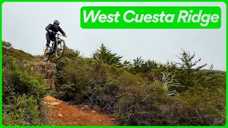
Steep and chunky with a few opportunities to send it big, Firebreak is a great option for advanced riders. Not quite as loose or as high speed as Botanical or Morning Glory, but it has a few sections that are definitely steeper and rockier. Firebreak starts off with a set of nicely crafted berms that lead in to a relatively easy and quick traverse. Then the trail turns right and becomes much steeper and rockier from there. A few optional jumps and one big ol' hucker drop (with a ride-around), are up there mixed in with the big chunky rock gardens typical of this area. While this trail is unsanctioned, it is NOT illegal to ride.

This trail is unsanctioned.

Disclaimer

Bottom of trail is only about 100 yards from military land, DO NOT CROSS MILITARY LAND BOUNDARY

Trail Supporters

  • USFS
    Land Manager
Traditionally Indigenous Territory

Recent Activity on Trail

Past Week
  • 1 rides
  • 13 miles average
6 Months
  • 9 rides
  • 12 miles avg distance
All
  • 53 rides
  • Last: Jun 13, 2026
c1c2c3c4
January
February
March
April
May
June
July
August
September
October
November
December
update trails status or condition

Firebreak Trail Reports

Status:
on Jul 30, 2025
Very Dry
Avg: 4.3 (7 votes)
Your vote: 0

view (582)
close
3D
Trail Conditions
  • Unknown
  • Snow Groomed
  • Snow Packed
  • Snow Covered
  • Snow Cover Partial
  • Freeze/thaw Cycle
  • Icy
  • Prevalent Mud
  • Wet
  • Variable
  • Ideal
  • Dry
  • Very Dry
Trail Flow (Ridden Direction)
Trailforks scans users ridelogs to determine the most popular direction each trail is ridden. A good flowing trail network will have most trails flowing in a single direction according to their intension.
The colour categories are based on what percentage of riders are riding a trail in its intended direction.
  • > 96%
  • > 90%
  • > 80%
  • > 70%
  • > 50%
  • < 50%
  • bi-directional trail
  • no data
Trail Last Ridden
Trailforks scans ridelogs to determine the last time a trail was ridden.
  • < 2 days
  • < 1 week
  • < 2 weeks
  • < 1 month
  • < 6 months
  • > 6 months
Trail Ridden Direction
The intended direction a trail should be ridden.
  • Downhill Only
  • Downhill Primary
  • Both Directions
  • Uphill Primary
  • Uphill Only
  • One Direction
Contribute Details
Colors indicate trail is missing specified detail.
  • Description
  • Photos
  • Description & Photos
  • Videos
Trail Popularity ?
Trailforks scans ridelogs to determine which trails are ridden the most in the last 9 months. Trails are compared with nearby trails in the same city region with a possible 25 colour shades. Think of this as a heatmap, more rides = more kinetic energy = warmer colors.
  • most popular
  • popular
  • less popular
  • not popular
ATV/ORV/OHV Filter
Max Vehicle Width
inches
US Cell Coverage
Legend
cell carrier legend

Radar Time
Activity Recordings
Trailforks uses anonymized public activity data. ?
Activity Recordings
Trailforks uses anonymized public activity data. ?
Personal Heatmap
Activity Types
all / none
Options
2
Date range month
Winter Trails
Warning A routing network for winter maps does not exist. Selecting trails using the winter trails layer has been disabled.
Missing Trails
Most Popular
Least Popular
Trails are colored based on popularity. The more popular a trail is, the more red. Less popular trails trend towards green.
Jump Magnitude Heatmap
Heatmap of where riders jump on trails. Zoom in to see individual jumps, click circles to view jump details.
BC Backroad Status

Service Road Atlas is a free to use, community-driven service for viewing and creating reports on the numerous back-country service roads around B.C. and Alberta.

map legend
Slope Aspect
Direction the slope faces
Flat N NE E SE S SW W NW
Trails Deemphasized
Trails are shown in grey.
disable
Only show trails with no bike usage.
Enable
Suggested Layers
Based on selected activity type

    Save the current map location and zoom level as your default home location whenever this page is loaded.

    Save
        Directions to firebreak-60013 trailhead (35.362420, -120.657470)

        Photos

        16 more »
        142 |
        Jan 15, 2018 @ 8:02am
        Jan 15, 2018
        192 |
        Jan 14, 2018 @ 4:25pm
        Jan 14, 2018
        119 |
        Jul 14, 2017 @ 6:00pm
        Jul 14, 2017
        170 |
        Jun 27, 2017 @ 9:05am
        Jun 27, 2017

        Videos

        4 more »
        youtuber Firebreak - West Cuesta Ridge
        28:41 | 229 | Jan 31, 2025 , San Luis Obispo
        youtuber The sun is still shining in SLO | Mountain...
        638 | Dec 8, 2017 , San Luis Obispo
        Santa Barbara Rides
        3:23 | 1109 | Nov 13, 2008 , San Luis Obispo
        Firebreak
        0:17 | 749 | Jan 16, 2010 , San Luis Obispo

        Routes with this trail

        5.0 12 miles 1,630 ft 35 Shuttled
        A great route for very advanced riders wanting to see the best descents San Luis Obispo has to offer. Not...
        5.0 7 miles 244 ft 14
        Advanced All-Mountain/Enduro route on West Cuesta Ridge. Rocks, tech, steeps, big hucks, and speed.
        4.0 27 miles 4,716 ft 49 Shuttled
        The near Ultimate Point to Point Shuttle route that covers all the major trail on the Ridge except for...

        1 Review & Comments


        We hope you've been enjoying Trailforks!

        Create a FREE account to view trail comments and much more.

        • #60013 - 2,120 views

        Frequently Asked Questions About Firebreak

        Where is Firebreak located?
        Firebreak is located in Cuesta Ridge West, San Luis Obispo, California, United States. It is part of the Cuesta Ridge West trail network. The trailhead is located at coordinates 35.36242, -120.65747.
        How hard is Firebreak?
        Firebreak is rated as Double Black Diamond difficulty. The average grade is 14.7%. The climb difficulty is rated Double Black Diamond.
        What is the elevation gain for Firebreak?
        Firebreak has 2 ft of elevation gain. The trail has 639 ft of elevation descent. The elevation ranges from 1,781 ft to 2,418 ft.
        Is Firebreak a point to point trail?
        Yes, Firebreak is a point to point trail. The direction is Downhill Only. The trail type is singletrack.

        Hit the Trail

        Open in App

        Get this trail on your phone instantly.
        open trail in app

        Download Trail

        Save to wishlist, Garmin & download.
        save the trail

        Find Related Routes

        Find routes and users activities that include this trail.
        find routes for this trail

        You must enter a description before submitting.