more stats
1,660 ft
Distance
-135 ft
Descent
00:01:58
Avg time
-135 ft
Altitude change
1,239 ft
Altitude min
1,374 ft
Altitude max
1,374 ft
Altitude start
1,240 ft
Altitude end
-8.2%
Grade
-17.3%
Grade max
-1.8%
Grade min
1,617 ft
Distance down
43 ft
Distance flat
00:01:58
Avg time

Fish Hook Details

  • Activities
    • Mountain Bike
  • Riding Area
    Sylvan Hill Park
    Wausau, Wisconsin
  • Difficulty Rating
  • Local Popularity
    80 in Mountain Biking
  • Global Ranking
    #60992 in Mountain Biking
  • Trail Type
    Singletrack
  • Bike Type
    DH
  • Direction
    One Direction
    Popular Direction Shown
  • Physical Rating
    Extreme
  • Season
    May thru October/November
  • Dogs Allowed
    Yes
  • TTFs on Trail
    Berm, Drop, Jump, Gap Jump
  • Year Opened
    2017
  • Land Owner

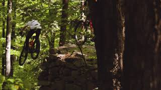
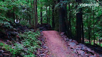
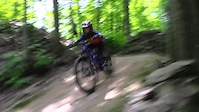
This is the most advanced run at Sylvan Hill. The entry jump feature is a solid 5' high rock lip, gap jump. The remainder of the trail afterwards is smooth with much more serious air required to clear the jumps. As with Bad Rabbit and Twisted Oak, you'll reconnect with Sylvan's Run for a return ride to the top of the hill for more fun.

Access Info

Trail head at: 3298 Coates Ln, Wausau, WI 54403

Local Trail Association

Recent Activity on Trail

Past Week
  • 0 rides
  •  
6 Months
  • 2 rides
  • 3 miles avg distance
All
  • 25 rides
  • Last: Jun 5, 2026
c1c2c3c4
January
February
March
April
May
June
July
August
September
October
November
December
update trails status or condition

Fish Hook Trail Reports

statusdatedescription
May 24, 2024 @ 10:01am
May 24, 2024
reporter Trails open with recent rainfall
Dec 19, 2023 @ 12:53pm
Dec 19, 2023
reporter Closed until 2024 season
Oct 10, 2023 @ 6:56am
Oct 10, 2023
reporter
May 30, 2022 @ 10:10pm
May 30, 2022
Dry, fast, a few avoidable wet spots in the lower common trail.
Jul 30, 2021 @ 8:19pm
Jul 30, 2021
Branches down everywhere, but no trees across the trail.
more »
Status:
on May 24, 2024
Wet
Avg: 4.21 (3 votes)
Your vote: 0

view (955)
close
3D
Trail Conditions
  • Unknown
  • Snow Groomed
  • Snow Packed
  • Snow Covered
  • Snow Cover Partial
  • Freeze/thaw Cycle
  • Icy
  • Prevalent Mud
  • Wet
  • Variable
  • Ideal
  • Dry
  • Very Dry
Trail Flow (Ridden Direction)
Trailforks scans users ridelogs to determine the most popular direction each trail is ridden. A good flowing trail network will have most trails flowing in a single direction according to their intension.
The colour categories are based on what percentage of riders are riding a trail in its intended direction.
  • > 96%
  • > 90%
  • > 80%
  • > 70%
  • > 50%
  • < 50%
  • bi-directional trail
  • no data
Trail Last Ridden
Trailforks scans ridelogs to determine the last time a trail was ridden.
  • < 2 days
  • < 1 week
  • < 2 weeks
  • < 1 month
  • < 6 months
  • > 6 months
Trail Ridden Direction
The intended direction a trail should be ridden.
  • Downhill Only
  • Downhill Primary
  • Both Directions
  • Uphill Primary
  • Uphill Only
  • One Direction
Contribute Details
Colors indicate trail is missing specified detail.
  • Description
  • Photos
  • Description & Photos
  • Videos
Trail Popularity ?
Trailforks scans ridelogs to determine which trails are ridden the most in the last 9 months. Trails are compared with nearby trails in the same city region with a possible 25 colour shades. Think of this as a heatmap, more rides = more kinetic energy = warmer colors.
  • most popular
  • popular
  • less popular
  • not popular
ATV/ORV/OHV Filter
Max Vehicle Width
inches
US Cell Coverage
Legend
cell carrier legend

Radar Time
Activity Recordings
Trailforks uses anonymized public activity data. ?
Activity Recordings
Trailforks uses anonymized public activity data. ?
Personal Heatmap
Activity Types
all / none
Options
2
Date range month
Winter Trails
Warning A routing network for winter maps does not exist. Selecting trails using the winter trails layer has been disabled.
Missing Trails
Most Popular
Least Popular
Trails are colored based on popularity. The more popular a trail is, the more red. Less popular trails trend towards green.
Jump Magnitude Heatmap
Heatmap of where riders jump on trails. Zoom in to see individual jumps, click circles to view jump details.
BC Backroad Status

Service Road Atlas is a free to use, community-driven service for viewing and creating reports on the numerous back-country service roads around B.C. and Alberta.

map legend
Slope Aspect
Direction the slope faces
Flat N NE E SE S SW W NW
Trails Deemphasized
Trails are shown in grey.
disable
Only show trails with no bike usage.
Enable
Suggested Layers
Based on selected activity type

    Save the current map location and zoom level as your default home location whenever this page is loaded.

    Save
        Directions to fish-hook trailhead (44.985050, -89.604100)

        Photos

        1 more »
        551 |
        Oct 19, 2020 @ 7:37am
        Oct 19, 2020

        Videos

        3 more »
        Sylvan Hill - Fish Hook
        2:13 | 586 | Oct 2, 2021 , Wausau
        Wausau n Lil Switz
        0:28 | 127 | Aug 24, 2022 , Wausau
        sketchy 10ft stepdown in Wisconsin
        0:19 | 400 | Nov 26, 2020 , Wausau

        Reviews / Comments

        No reviews yet, be the first to write a review or ask a question.
        Use trail reports to comment on trail conditions.


        We hope you've been enjoying Trailforks!

        Create a FREE account to view trail comments and much more.

        • By mblockTF Pro CWOCC & contributors
        • #102250 - 1,769 views

        Frequently Asked Questions About Fish Hook

        Where is Fish Hook located?
        Fish Hook is located in Sylvan Hill Park, Wausau, Wisconsin, United States. It is part of the Sylvan Hill Park trail network. The trailhead is located at coordinates 44.98505, -89.6041.
        How hard is Fish Hook?
        Fish Hook is rated as Double Black Diamond difficulty. The physical rating is Extreme. The average grade is 8.2%.
        What is the elevation gain for Fish Hook?
        The trail has 135 ft of elevation descent. The elevation ranges from 1,239 ft to 1,374 ft.
        Is Fish Hook a point to point trail?
        Yes, Fish Hook is a point to point trail. The direction is One Direction. The trail type is singletrack.

        Hit the Trail

        Open in App

        Get this trail on your phone instantly.
        open trail in app

        Download Trail

        Save to wishlist, Garmin & download.
        save the trail

        Find Related Routes

        Find routes and users activities that include this trail.
        find routes for this trail

        You must enter a description before submitting.