more stats
3,950 ft
Distance
20 ft
Climb
-122 ft
Descent
00:05:33
Avg time
-101 ft
Altitude change
2,582 ft
Altitude min
2,683 ft
Altitude max
2,683 ft
Altitude start
2,582 ft
Altitude end
-2.6%
Grade
-20.1%
Grade max
6.8%
Grade min
564 ft
Distance climb
2,362 ft
Distance down
1,024 ft
Distance flat
00:05:33
Avg time

Flashback 1 Details

  • Activities
    • Mountain Bike
    • E-Bike
    • Adaptive Bike
    • Hike
    • Trail Running
  • Riding Area
    Cheakamus
    Whistler, British Columbia
  • Difficulty Rating
  • Local Popularity
    90 in Mountain Biking [+]
    • 90 in E-Biking
    • 70 in Trail Running
    • 70 in Hiking
  • Global Ranking
    #49400 in Mountain Biking [+]
    • #24306 in E-Biking
    • #73610 in Trail Running
    • #63866 in Hiking
  • Hiking SAC Scale
    T1 Hiking
  • Trail Type
    Singletrack
  • Bike Type
    AM, XC, Adaptive MTB
  • Direction
    Downhill Primary
    Popular Direction Shown
  • Climb Difficulty
    Blue
  • Physical Rating
    Moderate
  • Trail Visibility
    Always easy to follow
  • Family Friendly
    Yes
  • Dogs Allowed
    Yes
  • eBike Allowed
    Yes up to Class 1
  • TTFs on Trail
    Bridge
  • Ride in Rain
    Yes
  • Year Opened
    2023

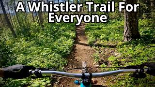
Very "light blue" trail with little climbs between flowy low angle descents.
Built by volunteers to Blue KASA Adaptive standard. Built to adaptive mtb standards thanks to funding from a Fox Factory Trail Trust grant.

Adaptive Bike Info
aMTB Blue Rating: Intermediate features and steeper terrain.

Flashback 1 has been completely widened to 1.2m thanks to a grant from the Fox Factory Trail Fund!

Local Trail Association

Recent Activity on Trail

Past Week
  • 15 rides
  • 17 miles average
6 Months
  • 136 rides
  • 13 miles avg distance
All
  • 1,022 rides
  • Last: Jun 5, 2026
c1c2c3c4
January
February
March
April
May
June
July
August
September
October
November
December
Status:
on May 9, 2026
Ideal
Avg: 4.19 (5 votes)
Your vote: 0

view (3,728)
close
3D
Trail Conditions
  • Unknown
  • Snow Groomed
  • Snow Packed
  • Snow Covered
  • Snow Cover Partial
  • Freeze/thaw Cycle
  • Icy
  • Prevalent Mud
  • Wet
  • Variable
  • Ideal
  • Dry
  • Very Dry
Trail Flow (Ridden Direction)
Trailforks scans users ridelogs to determine the most popular direction each trail is ridden. A good flowing trail network will have most trails flowing in a single direction according to their intension.
The colour categories are based on what percentage of riders are riding a trail in its intended direction.
  • > 96%
  • > 90%
  • > 80%
  • > 70%
  • > 50%
  • < 50%
  • bi-directional trail
  • no data
Trail Last Ridden
Trailforks scans ridelogs to determine the last time a trail was ridden.
  • < 2 days
  • < 1 week
  • < 2 weeks
  • < 1 month
  • < 6 months
  • > 6 months
Trail Ridden Direction
The intended direction a trail should be ridden.
  • Downhill Only
  • Downhill Primary
  • Both Directions
  • Uphill Primary
  • Uphill Only
  • One Direction
Contribute Details
Colors indicate trail is missing specified detail.
  • Description
  • Photos
  • Description & Photos
  • Videos
Trail Popularity ?
Trailforks scans ridelogs to determine which trails are ridden the most in the last 9 months. Trails are compared with nearby trails in the same city region with a possible 25 colour shades. Think of this as a heatmap, more rides = more kinetic energy = warmer colors.
  • most popular
  • popular
  • less popular
  • not popular
ATV/ORV/OHV Filter
Max Vehicle Width
inches
US Cell Coverage
Legend
cell carrier legend

Radar Time
Activity Recordings
Trailforks uses anonymized public activity data. ?
Activity Recordings
Trailforks uses anonymized public activity data. ?
Personal Heatmap
Activity Types
all / none
Options
2
Date range month
Winter Trails
Warning A routing network for winter maps does not exist. Selecting trails using the winter trails layer has been disabled.
Missing Trails
Most Popular
Least Popular
Trails are colored based on popularity. The more popular a trail is, the more red. Less popular trails trend towards green.
Jump Magnitude Heatmap
Heatmap of where riders jump on trails. Zoom in to see individual jumps, click circles to view jump details.
BC Backroad Status

Service Road Atlas is a free to use, community-driven service for viewing and creating reports on the numerous back-country service roads around B.C. and Alberta.

map legend
Slope Aspect
Direction the slope faces
Flat N NE E SE S SW W NW
Trails Deemphasized
Trails are shown in grey.
disable
Only show trails with no bike usage.
Enable
Suggested Layers
Based on selected activity type

    Save the current map location and zoom level as your default home location whenever this page is loaded.

    Save
        Directions to flashback-1 trailhead (50.046760, -123.017650)

        Photos

        8 more »
        141 |
        May 13, 2024 @ 3:18pm
        May 13, 2024
        22 |
        Mar 13, 2026 @ 6:19pm
        Mar 13, 2026
        29 |
        Mar 13, 2026 @ 6:18pm
        Mar 13, 2026
        57 |
        Feb 21, 2026 @ 9:44pm
        Feb 21, 2026

        Videos

        1 more »
        youtuber Kids? Shuttle? Intermediate? This Whistler...
        14:08 | 12 | May 28, 2026 , Whistler

        Routes with this trail

        5.0 13 miles 1,787 ft 12 Loop
        Start in Checkamus carpark. Take a right out onto 'Checkamus Village Valley Trail'. Go left at 'Eastside...
        3 miles 131 ft 5
        WORCA Virtual Chiller Monday, August 19- Saturday, August 14 Collect your badge to earn your Apres deal...
        41 miles 9,428 ft 23
        kmkimkmkmkmkmkmkmkmkkmkmmnmmmm. mmmmm. mmm.

        Trail Products

        Reviews / Comments

        No reviews yet, be the first to write a review or ask a question.
        Use trail reports to comment on trail conditions.


        We hope you've been enjoying Trailforks!

        Create a FREE account to view trail comments and much more.

        • By flipfantasiaTF Pro WORCA & contributors
        • #124574 - 6,330 views

        Frequently Asked Questions About Flashback 1

        Where is Flashback 1 located?
        Flashback 1 is located in Cheakamus, Whistler, British Columbia, Canada. It is part of the Cheakamus trail network. The trailhead is located at coordinates 50.04676, -123.01765.
        How hard is Flashback 1?
        Flashback 1 is rated as Blue difficulty. The physical rating is Moderate. The average grade is 2.6%. The climb difficulty is rated Blue.
        What is the elevation gain for Flashback 1?
        Flashback 1 has 6 m of elevation gain. The trail has 37 m of elevation descent. The elevation ranges from 787 m to 818 m.
        Is Flashback 1 a point to point trail?
        Flashback 1 is not a point to point trail. The direction is Downhill Primary. The trail type is singletrack.

        Hit the Trail

        Open in App

        Get this trail on your phone instantly.
        open trail in app

        Download Trail

        Save to wishlist, Garmin & download.
        save the trail

        Find Related Routes

        Find routes and users activities that include this trail.
        find routes for this trail

        You must enter a description before submitting.