more stats
3,241 ft
Distance
5 ft
Climb
-330 ft
Descent
00:03:45
Avg time
-326 ft
Altitude change
6,366 ft
Altitude min
6,699 ft
Altitude max
6,693 ft
Altitude start
6,368 ft
Altitude end
-10.1%
Grade
-29.2%
Grade max
24.7%
Grade min
279 ft
Distance climb
2,490 ft
Distance down
476 ft
Distance flat
00:03:45
Avg time

Flè Trail Details

  • Activities
    • Mountain Bike
    • E-Bike
  • Riding Area
  • Difficulty Rating
  • Local Popularity
    100 in Mountain Biking [+]
    • 100 in E-Biking
  • Global Ranking
    #2271 in Mountain Biking [+]
    • #2509 in E-Biking
  • Trail Type
    Singletrack
  • Bike Type
    AM, XC
  • Direction
    Downhill Only
    Popular Direction Shown
  • Physical Rating
    Easy
  • Trail Visibility
    Always easy to follow
  • eBike Allowed
    Yes up to Class 1
  • TTFs on Trail
    Bridge

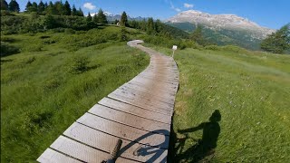
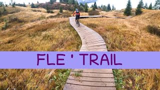
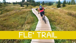
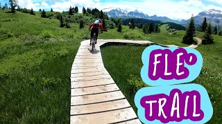
One of the Sellaronda trails. It leads from Rifugio Pralongià to Passo Incisa, nearby Rifugio La Marmotta.
Uno dei sentieri del Sellaronda. Porta dal Rifugio Pralongià al Passo Incisa, nei pressi del rifugio La Marmotta.

Bike Park

Recent Activity on Trail

Past Week
  • 20 rides
  • 40 miles average
6 Months
  • 21 rides
  • 39 miles avg distance
All
  • 389 rides
  • Last: Jun 19, 2026
c1c2c3c4
January
February
March
April
May
June
July
August
September
October
November
December
update trails status or condition

Flè Trail Trail Reports

Status:
on Jun 13, 2026
Ideal
Avg: 3.47 (11 votes)
Your vote: 0

view (2,727)
close
3D
Trail Conditions
  • Unknown
  • Snow Groomed
  • Snow Packed
  • Snow Covered
  • Snow Cover Partial
  • Freeze/thaw Cycle
  • Icy
  • Prevalent Mud
  • Wet
  • Variable
  • Ideal
  • Dry
  • Very Dry
Trail Flow (Ridden Direction)
Trailforks scans users ridelogs to determine the most popular direction each trail is ridden. A good flowing trail network will have most trails flowing in a single direction according to their intension.
The colour categories are based on what percentage of riders are riding a trail in its intended direction.
  • > 96%
  • > 90%
  • > 80%
  • > 70%
  • > 50%
  • < 50%
  • bi-directional trail
  • no data
Trail Last Ridden
Trailforks scans ridelogs to determine the last time a trail was ridden.
  • < 2 days
  • < 1 week
  • < 2 weeks
  • < 1 month
  • < 6 months
  • > 6 months
Trail Ridden Direction
The intended direction a trail should be ridden.
  • Downhill Only
  • Downhill Primary
  • Both Directions
  • Uphill Primary
  • Uphill Only
  • One Direction
Contribute Details
Colors indicate trail is missing specified detail.
  • Description
  • Photos
  • Description & Photos
  • Videos
Trail Popularity ?
Trailforks scans ridelogs to determine which trails are ridden the most in the last 9 months. Trails are compared with nearby trails in the same city region with a possible 25 colour shades. Think of this as a heatmap, more rides = more kinetic energy = warmer colors.
  • most popular
  • popular
  • less popular
  • not popular
ATV/ORV/OHV Filter
Max Vehicle Width
inches
US Cell Coverage
Legend
cell carrier legend

Radar Time
Activity Recordings
Trailforks uses anonymized public activity data. ?
Activity Recordings
Trailforks uses anonymized public activity data. ?
Personal Heatmap
Activity Types
all / none
Options
2
Date range month
Winter Trails
Warning A routing network for winter maps does not exist. Selecting trails using the winter trails layer has been disabled.
Missing Trails
Most Popular
Least Popular
Trails are colored based on popularity. The more popular a trail is, the more red. Less popular trails trend towards green.
Jump Magnitude Heatmap
Heatmap of where riders jump on trails. Zoom in to see individual jumps, click circles to view jump details.
BC Backroad Status

Service Road Atlas is a free to use, community-driven service for viewing and creating reports on the numerous back-country service roads around B.C. and Alberta.

map legend
Slope Aspect
Direction the slope faces
Flat N NE E SE S SW W NW
Trails Deemphasized
Trails are shown in grey.
disable
Only show trails with no bike usage.
Enable
Suggested Layers
Based on selected activity type

    Save the current map location and zoom level as your default home location whenever this page is loaded.

    Save
        Directions to fle-trail trailhead (46.533830, 11.907880)

        Photos

        5 more »
        64 |
        Jul 22, 2025 @ 4:43am
        Jul 22, 2025
        106 |
        Sep 24, 2023 @ 5:12am
        Sep 24, 2023
        95 |
        Sep 24, 2023 @ 5:12am
        Sep 24, 2023
        75 |
        Sep 24, 2023 @ 5:12am
        Sep 24, 2023

        Videos

        6 more »
        youtuber Fle Trail - Bike Beats | Sellaronda MTB Tour
        8:01 | 264 | Aug 14, 2023 , Corvara
        youtuber MTB Dolomiti Sellaronda 24.09.2022 sentiero...
        8:57 | 315 | Oct 2, 2022 , Corvara
        youtuber MTB Dolomiti Sellaronda 20.09.2023 sentiero...
        10:29 | 141 | Sep 24, 2023 , Corvara
        youtuber MTB Dolomiti Sellaronda 03.07.2021 sentiero...
        3:02 | 442 | Jul 9, 2021 , Corvara

        Routes with this trail

        3.5 37 miles 11,351 ft 6 Loop
        Official Sellaronda MTB Tour - Clockwise direction Choices made: - chosen instead of - fixed official GPX...
        5.0 39 miles 11,488 ft 5 Loop
        Official Sellaronda MTB Tour - Clockwise direction Choices made: - chosen instead of - fixed official GPX...
        4.0 38 miles 12,500 ft 11
        XXXXXXXXXXXXXXXXXXXXXXXXX

        2 Reviews & Comments


        We hope you've been enjoying Trailforks!

        Create a FREE account to view trail comments and much more.

        • By iosonoFREERIDETF Pro & contributors
        • #448478 - 1,952 views

        Frequently Asked Questions About Flè Trail

        Where is Flè Trail located?
        Flè Trail is located in Bike Beats - Movimënt Alta Badia Trails, Corvara, Italy. It is part of the Bike Beats - Movimënt Alta Badia Trails trail network. The trailhead is located at coordinates 46.53383, 11.90788.
        How hard is Flè Trail?
        Flè Trail is rated as Green difficulty. The physical rating is Easy. The average grade is 10.1%.
        What is the elevation gain for Flè Trail?
        Flè Trail has 2 m of elevation gain. The trail has 101 m of elevation descent. The elevation ranges from 1,940 m to 2,042 m.
        Is Flè Trail a point to point trail?
        Yes, Flè Trail is a point to point trail. The direction is Downhill Only. The trail type is singletrack.

        Hit the Trail

        Open in App

        Get this trail on your phone instantly.
        open trail in app

        Download Trail

        Save to wishlist, Garmin & download.
        save the trail

        Find Related Routes

        Find routes and users activities that include this trail.
        find routes for this trail

        You must enter a description before submitting.