more stats
1.0 mile
Distance
21 ft
Climb
-484 ft
Descent
00:08:06
Avg time
-463 ft
Altitude change
2,491 ft
Altitude min
2,954 ft
Altitude max
2,954 ft
Altitude start
2,490 ft
Altitude end
-8.4%
Grade
-37.9%
Grade max
7.5%
Grade min
492 ft
Distance climb
4,731 ft
Distance down
318 ft
Distance flat
00:08:06
Avg time

Flovid Details

  • Activities
    • Mountain Bike
    • E-Bike
    • Hike
    • Trail Running
  • Riding Area
    Kalamalka Lake
    Vernon, British Columbia
  • Difficulty Rating
  • Local Popularity
    100 in Mountain Biking [+]
    • 100 in E-Biking
    • 70 in Trail Running
    • 75 in Hiking
  • Global Ranking
    #26840 in Mountain Biking [+]
    • #2284 in E-Biking
    • #72224 in Trail Running
    • #62376 in Hiking
  • Trail Type
    Machine Groomed
  • Bike Type
    AM, XC
  • Climb Difficulty
    Blue
  • Physical Rating
    Moderate
  • Trail Visibility
    Always easy to follow
  • Family Friendly
    Yes
  • Dogs Allowed
    Yes
  • eBike Allowed
  • TTFs on Trail
    Berm, Bridge, Jump
  • Year Opened
    2020
  • Land Owner

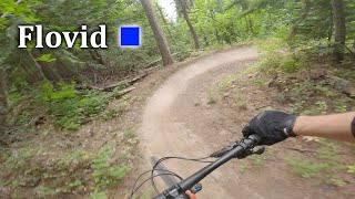
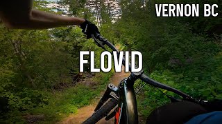
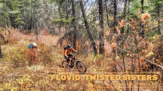
Brand new trail opened May 2020, funded by NOCS via memberships, donations and the Kal Rotary Grant. This is a machine built flow trail that is fun for all levels. Good flow with optional hits along the way, it's a great addition to the Kal Park and is different than all the other trails in the area.

Access Info

climb Rotten Cabin from the HRT or descend Big Ed then take Rotten Cabin down past Jimmy Thang and Fraidy Cat.

Local Trail Association

Recent Activity on Trail

Past Week
  • 7 rides
  • 14 miles average
6 Months
  • 153 rides
  • 11 miles avg distance
All
  • 1,573 rides
  • Last: Jun 22, 2026
c1c2c3c4
January
February
March
April
May
June
July
August
September
October
November
December
Status:
on Jun 9, 2026
Ideal
Avg: 4.26 (21 votes)
Your vote: 0

view (9,126)
close
3D
Trail Conditions
  • Unknown
  • Snow Groomed
  • Snow Packed
  • Snow Covered
  • Snow Cover Partial
  • Freeze/thaw Cycle
  • Icy
  • Prevalent Mud
  • Wet
  • Variable
  • Ideal
  • Dry
  • Very Dry
Trail Flow (Ridden Direction)
Trailforks scans users ridelogs to determine the most popular direction each trail is ridden. A good flowing trail network will have most trails flowing in a single direction according to their intension.
The colour categories are based on what percentage of riders are riding a trail in its intended direction.
  • > 96%
  • > 90%
  • > 80%
  • > 70%
  • > 50%
  • < 50%
  • bi-directional trail
  • no data
Trail Last Ridden
Trailforks scans ridelogs to determine the last time a trail was ridden.
  • < 2 days
  • < 1 week
  • < 2 weeks
  • < 1 month
  • < 6 months
  • > 6 months
Trail Ridden Direction
The intended direction a trail should be ridden.
  • Downhill Only
  • Downhill Primary
  • Both Directions
  • Uphill Primary
  • Uphill Only
  • One Direction
Contribute Details
Colors indicate trail is missing specified detail.
  • Description
  • Photos
  • Description & Photos
  • Videos
Trail Popularity ?
Trailforks scans ridelogs to determine which trails are ridden the most in the last 9 months. Trails are compared with nearby trails in the same city region with a possible 25 colour shades. Think of this as a heatmap, more rides = more kinetic energy = warmer colors.
  • most popular
  • popular
  • less popular
  • not popular
ATV/ORV/OHV Filter
Max Vehicle Width
inches
US Cell Coverage
Legend
cell carrier legend

Radar Time
Activity Recordings
Trailforks uses anonymized public activity data. ?
Activity Recordings
Trailforks uses anonymized public activity data. ?
Personal Heatmap
Activity Types
all / none
Options
2
Date range month
Winter Trails
Warning A routing network for winter maps does not exist. Selecting trails using the winter trails layer has been disabled.
Missing Trails
Most Popular
Least Popular
Trails are colored based on popularity. The more popular a trail is, the more red. Less popular trails trend towards green.
Jump Magnitude Heatmap
Heatmap of where riders jump on trails. Zoom in to see individual jumps, click circles to view jump details.
BC Backroad Status

Service Road Atlas is a free to use, community-driven service for viewing and creating reports on the numerous back-country service roads around B.C. and Alberta.

map legend
Slope Aspect
Direction the slope faces
Flat N NE E SE S SW W NW
Trails Deemphasized
Trails are shown in grey.
disable
Only show trails with no bike usage.
Enable
Suggested Layers
Based on selected activity type

    Save the current map location and zoom level as your default home location whenever this page is loaded.

    Save
        Directions to flovid trailhead (50.185890, -119.236870)

        Photos

        30 more »
        69 |
        Apr 22, 2022 @ 10:16pm
        Apr 22, 2022
        74 |
        Apr 22, 2022 @ 10:16pm
        Apr 22, 2022
        62 |
        Apr 22, 2022 @ 10:16pm
        Apr 22, 2022
        69 |
        Apr 22, 2022 @ 10:16pm
        Apr 22, 2022

        Videos

        4 more »
        Pandemic Flow | Flovid - Kalamalka Mtn
        5:58 | 327 | Jul 18, 2023 , Vernon
        youtuber Flovid - Okanagan Mountain Biking
        4:41 | 327 | Jun 2, 2023 , Vernon
        Kalamalka Park MTB: Stone Free, Flovid,...
        3:55 | 192 | Oct 11, 2022 , Vernon
        First Ride on a Brand New Trail in Vernon BC
        5:36 | 920 | Jun 8, 2020 , Vernon

        Routes with this trail

        4.0 30 miles 6,043 ft 16 Loop
        Big views, big climbs and an extended 14 km single-track (almost) continuous descent from the high point,...
        5.0 7 miles 1,405 ft 8
        Vernon Ladies Virtual Shop Ride #5 Head out from the Cougar lot. Take the road until taking a right on...
        3 miles 51 ft 3
        NOCS Fiver Downhill course! The final instalment of our fall race series. Get up to the top of at your own...

        9 Reviews & Comments


        We hope you've been enjoying Trailforks!

        Create a FREE account to view trail comments and much more.

        Nearby Trails

        • By jmartTF Pro SSMR NOCS & contributors
        • #292064 - 6,399 views

        Frequently Asked Questions About Flovid

        Where is Flovid located?
        Flovid is located in Kalamalka Lake, Vernon, British Columbia, Canada. It is part of the Kalamalka Lake trail network. The trailhead is located at coordinates 50.18589, -119.23687.
        How hard is Flovid?
        Flovid is rated as Blue difficulty. The physical rating is Moderate. The average grade is 8.4%. The climb difficulty is rated Blue.
        What is the elevation gain for Flovid?
        Flovid has 6 m of elevation gain. The trail has 148 m of elevation descent. The elevation ranges from 759 m to 900 m.
        How long is Flovid?
        Flovid is 1.7 km long. The trail type is machine groomed.

        Hit the Trail

        Open in App

        Get this trail on your phone instantly.
        open trail in app

        Download Trail

        Save to wishlist, Garmin & download.
        save the trail

        Find Related Routes

        Find routes and users activities that include this trail.
        find routes for this trail

        You must enter a description before submitting.