more stats
2,933 ft
Distance
-346 ft
Descent
00:03:54
Avg time
-346 ft
Altitude change
8,725 ft
Altitude min
9,071 ft
Altitude max
9,071 ft
Altitude start
8,724 ft
Altitude end
-11.8%
Grade
-33.7%
Grade max
-2%
Grade min
2,920 ft
Distance down
16 ft
Distance flat
00:03:54
Avg time

Flow Details

  • Activities
    • Mountain Bike
    • E-Bike
    • Adaptive Bike
  • Riding Area
    Mammoth Mountain Bike Park
    Mammoth Lakes, California
  • Difficulty Rating
  • Local Popularity
    60 in Mountain Biking [+]
    • 60 in E-Biking
  • Global Ranking
    #89317 in Mountain Biking [+]
    • #78972 in E-Biking
  • Trail Type
    Singletrack
  • Bike Type
  • Direction
    Downhill Only
    Popular Direction Shown
  • eBike Allowed
    Yes up to Class 1
  • TTFs on Trail
    Drop, Skinny, Wallride

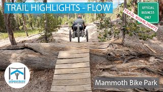
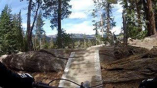
Fast, technical downhill with an optional ladder drop. Gets pretty steep in some sections.

Access Info

Starts from brake through and drops to the fireroad at shotgun. Pipeline is about a third of the way down.

Adaptive Bike Info
aMTB Blue Rating: Intermediate features and steeper terrain.

Most adaptive riders will be completely fine on this trail, even though it's a double black. There are ride arounds for everything. For riders with front wheel drive, there is one steep little ramp over a log you might need a push over. Thats what makes this trail aMTB2. There will be a lot of sliding around in the kitty litter too. Access via Brake Through and the Flow Fall-Line Shortcut. The sort cut kinda sucks -- Its steep and loose -- but if you don't take it, you'll up on an exposed section of Brake Through where you will need a spot.

Trail Supporters

  • USFS
    Land Manager

Bike Park

Recent Activity on Trail

Past Week
  • 0 rides
  •  
6 Months
  • 0 rides
  •  
All
  • 60 rides
  • Last: Jun 13, 2026
c1c2c3c4
January
February
March
April
May
June
July
August
September
October
November
December
update trails status or condition

Flow Trail Reports

Status:
on Jul 26, 2022
Very Dry
Avg: 4.44 (12 votes)
Your vote: 0

view (1,455)
close
3D
Trail Conditions
  • Unknown
  • Snow Groomed
  • Snow Packed
  • Snow Covered
  • Snow Cover Partial
  • Freeze/thaw Cycle
  • Icy
  • Prevalent Mud
  • Wet
  • Variable
  • Ideal
  • Dry
  • Very Dry
Trail Flow (Ridden Direction)
Trailforks scans users ridelogs to determine the most popular direction each trail is ridden. A good flowing trail network will have most trails flowing in a single direction according to their intension.
The colour categories are based on what percentage of riders are riding a trail in its intended direction.
  • > 96%
  • > 90%
  • > 80%
  • > 70%
  • > 50%
  • < 50%
  • bi-directional trail
  • no data
Trail Last Ridden
Trailforks scans ridelogs to determine the last time a trail was ridden.
  • < 2 days
  • < 1 week
  • < 2 weeks
  • < 1 month
  • < 6 months
  • > 6 months
Trail Ridden Direction
The intended direction a trail should be ridden.
  • Downhill Only
  • Downhill Primary
  • Both Directions
  • Uphill Primary
  • Uphill Only
  • One Direction
Contribute Details
Colors indicate trail is missing specified detail.
  • Description
  • Photos
  • Description & Photos
  • Videos
Trail Popularity ?
Trailforks scans ridelogs to determine which trails are ridden the most in the last 9 months. Trails are compared with nearby trails in the same city region with a possible 25 colour shades. Think of this as a heatmap, more rides = more kinetic energy = warmer colors.
  • most popular
  • popular
  • less popular
  • not popular
ATV/ORV/OHV Filter
Max Vehicle Width
inches
US Cell Coverage
Legend
cell carrier legend

Radar Time
Activity Recordings
Trailforks uses anonymized public activity data. ?
Activity Recordings
Trailforks uses anonymized public activity data. ?
Personal Heatmap
Activity Types
all / none
Options
2
Date range month
Winter Trails
Warning A routing network for winter maps does not exist. Selecting trails using the winter trails layer has been disabled.
Missing Trails
Most Popular
Least Popular
Trails are colored based on popularity. The more popular a trail is, the more red. Less popular trails trend towards green.
Jump Magnitude Heatmap
Heatmap of where riders jump on trails. Zoom in to see individual jumps, click circles to view jump details.
BC Backroad Status

Service Road Atlas is a free to use, community-driven service for viewing and creating reports on the numerous back-country service roads around B.C. and Alberta.

map legend
Slope Aspect
Direction the slope faces
Flat N NE E SE S SW W NW
Trails Deemphasized
Trails are shown in grey.
disable
Only show trails with no bike usage.
Enable
Suggested Layers
Based on selected activity type

    Save the current map location and zoom level as your default home location whenever this page is loaded.

    Save
        Directions to flow-25052 trailhead (37.644510, -119.019260)

        Photos

        13 more »
        237 |
        Jan 8, 2015 @ 9:32am
        Jan 8, 2015
        113 |
        Sep 29, 2020 @ 11:11am
        Sep 29, 2020
        118 |
        Sep 29, 2020 @ 10:48am
        Sep 29, 2020
        358 |
        Aug 28, 2012 @ 10:38am
        Aug 28, 2012

        Videos

        14 more »
        TRAIL HIGHLIGHTS - Flow - Adaptive MTB -...
        2:37 | 336 | Dec 29, 2020 , Mammoth Lakes
        Mammoth Mountain Bike Park - Flow Trail
        2:44 | 555 | Nov 14, 2018 , Mammoth Lakes
        Scorpion Clowns
        3:12 | 374 | Oct 18, 2011 , Mammoth Lakes
        top of flow at mammoth
        0:18 | 222 | Jul 30, 2012 , Mammoth Lakes

        Routes with this trail

        3 miles 92 ft 22 Point to Point
        Best trail combo from Mid to Canyon. Optional to Smooth Operator. Adaptive Rider info: - There are a...
        3 miles 96 ft 25 Point to Point
        Smooth Operator is sort of an extension of and its customary to link them. All kinds of good stuff o this...
        3 miles 101 ft 23 Point to Point
        Long burner from Mid to Canyon Adaptive Info: I choose to forego the part of that goes around the lake and...

        Trail Products

        Reviews / Comments

        No reviews yet, be the first to write a review or ask a question.
        Use trail reports to comment on trail conditions.


        We hope you've been enjoying Trailforks!

        Create a FREE account to view trail comments and much more.

        • By TheAngryTomatoTF Pro TRAILFORKS & contributors
        • #25052 - 3,444 views

        Frequently Asked Questions About Flow

        Where is Flow located?
        Flow is located in Mammoth Mountain Bike Park, Mammoth Lakes, California, United States. It is part of the Mammoth Mountain Bike Park trail network. The trailhead is located at coordinates 37.64451, -119.01926.
        How hard is Flow?
        Flow is rated as Double Black Diamond difficulty. The average grade is 11.8%.
        What is the elevation gain for Flow?
        The trail has 346 ft of elevation descent. The elevation ranges from 8,725 ft to 9,071 ft.
        Is Flow a point to point trail?
        Yes, Flow is a point to point trail. The direction is Downhill Only. The trail type is singletrack.

        Hit the Trail

        Open in App

        Get this trail on your phone instantly.
        open trail in app

        Download Trail

        Save to wishlist, Garmin & download.
        save the trail

        Find Related Routes

        Find routes and users activities that include this trail.
        find routes for this trail

        You must enter a description before submitting.