more stats
3,248 ft
Distance
-366 ft
Descent
00:02:24
Avg time
-366 ft
Altitude change
1,855 ft
Altitude min
2,221 ft
Altitude max
2,221 ft
Altitude start
1,854 ft
Altitude end
-11.3%
Grade
-25.2%
Grade max
1.8%
Grade min
20 ft
Distance climb
3,097 ft
Distance down
131 ft
Distance flat
00:02:24
Avg time

Flow Coaster Upper Details

  • Activities
    • Mountain Bike
    • E-Bike
  • Riding Area
    Three Blind Mice
    Penticton, British Columbia
  • Difficulty Rating
  • Local Popularity
    100 in Mountain Biking [+]
    • 100 in E-Biking
  • Global Ranking
    #16631 in Mountain Biking [+]
    • #3179 in E-Biking
  • Trail Type
    Singletrack
  • Bike Type
    DH, AM, XC, DJ
  • Physical Rating
    Easy
  • Trail Visibility
    Always easy to follow
  • Family Friendly
    Yes
  • Dogs Allowed
    Yes
  • eBike Allowed
    Yes up to Class 1
  • TTFs on Trail
    Berm, Jump
  • Year Opened
    2019

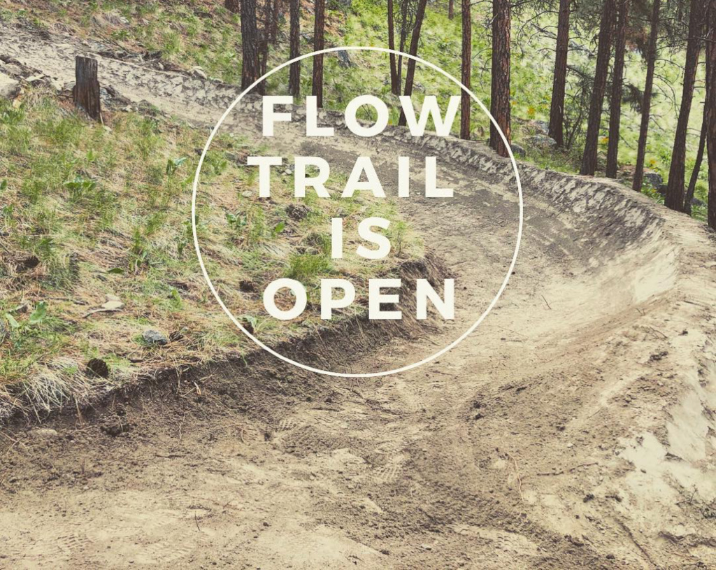
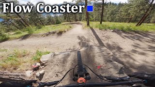
Newest addition to the Mice network. An easy flow trail that leads down to the Flow Coaster jump line or you can zip over to the continuation of it parallel to Tsweet Tsue.

Flowcoaster is now open

Trail Supporters
  • past supporters

Local Trail Association

Recent Activity on Trail

Past Week
  • 17 rides
  • 14.6 km average
6 Months
  • 118 rides
  • 17.6 km avg distance
All
  • 1,791 rides
  • Last: Jun 20, 2026
c1c2c3c4
January
February
March
April
May
June
July
August
September
October
November
December
update trails status or condition

Flow Coaster Upper Trail Reports

Status:
on Mar 15, 2026
Very Dry
Avg: 4.59 (39 votes)
Your vote: 0

view (8,011)
close
3D
Trail Conditions
  • Unknown
  • Snow Groomed
  • Snow Packed
  • Snow Covered
  • Snow Cover Partial
  • Freeze/thaw Cycle
  • Icy
  • Prevalent Mud
  • Wet
  • Variable
  • Ideal
  • Dry
  • Very Dry
Trail Flow (Ridden Direction)
Trailforks scans users ridelogs to determine the most popular direction each trail is ridden. A good flowing trail network will have most trails flowing in a single direction according to their intension.
The colour categories are based on what percentage of riders are riding a trail in its intended direction.
  • > 96%
  • > 90%
  • > 80%
  • > 70%
  • > 50%
  • < 50%
  • bi-directional trail
  • no data
Trail Last Ridden
Trailforks scans ridelogs to determine the last time a trail was ridden.
  • < 2 days
  • < 1 week
  • < 2 weeks
  • < 1 month
  • < 6 months
  • > 6 months
Trail Ridden Direction
The intended direction a trail should be ridden.
  • Downhill Only
  • Downhill Primary
  • Both Directions
  • Uphill Primary
  • Uphill Only
  • One Direction
Contribute Details
Colors indicate trail is missing specified detail.
  • Description
  • Photos
  • Description & Photos
  • Videos
Trail Popularity ?
Trailforks scans ridelogs to determine which trails are ridden the most in the last 9 months. Trails are compared with nearby trails in the same city region with a possible 25 colour shades. Think of this as a heatmap, more rides = more kinetic energy = warmer colors.
  • most popular
  • popular
  • less popular
  • not popular
ATV/ORV/OHV Filter
Max Vehicle Width
inches
US Cell Coverage
Legend
cell carrier legend

Radar Time
Activity Recordings
Trailforks uses anonymized public activity data. ?
Activity Recordings
Trailforks uses anonymized public activity data. ?
Personal Heatmap
Activity Types
all / none
Options
2
Date range month
Winter Trails
Warning A routing network for winter maps does not exist. Selecting trails using the winter trails layer has been disabled.
Missing Trails
Most Popular
Least Popular
Trails are colored based on popularity. The more popular a trail is, the more red. Less popular trails trend towards green.
Jump Magnitude Heatmap
Heatmap of where riders jump on trails. Zoom in to see individual jumps, click circles to view jump details.
BC Backroad Status

Service Road Atlas is a free to use, community-driven service for viewing and creating reports on the numerous back-country service roads around B.C. and Alberta.

map legend
Slope Aspect
Direction the slope faces
Flat N NE E SE S SW W NW
Trails Deemphasized
Trails are shown in grey.
disable
Only show trails with no bike usage.
Enable
Suggested Layers
Based on selected activity type

    Save the current map location and zoom level as your default home location whenever this page is loaded.

    Save
        Directions to flow-coaster-upper-180136 trailhead (49.549460, -119.549420)

        Photos

        18 more »
        302 |
        May 26, 2019 @ 5:33pm
        May 26, 2019
        512 |
        May 3, 2019 @ 10:30am
        May 3, 2019
        28 |
        Oct 7, 2024 @ 3:53pm
        Oct 7, 2024
        31 |
        Oct 7, 2024 @ 3:45pm
        Oct 7, 2024

        Videos

        10 more »
        youtuber Flow Coaster & Tsweet Tsue - Three Blind...
        3:59 | 613 | May 28, 2022 , Penticton
        youtuber The Mice is Nice (Flow Coaster Sneak Peek) |...
        12:06 | 616 | May 3, 2019 , Penticton
        Penticton Perfection : Riding The Best MTB...
        30:38 | 48 | Apr 7, 2025 , Penticton
        Trail Gap | Flow Coaster - Three Blind Mice
        3:37 | 106 | Oct 5, 2024 , Penticton

        Routes with this trail

        4.0 14 miles 2,247 ft 11
        Swagman's Backyard Ride Guide is back - this time, in two parts for the largest of the Penticton Trail...
        4.0 15 miles 2,706 ft 9 Loop
        A classic climb and descent to give you the most bang for your buck in the Mice. Suitable for intermediate...
        10 miles 1,823 ft 8
        Going fast is the name of the game on this lap. The climb along and Neverland will take you to mid-network...

        Trail Products

        3 Reviews & Comments


        We hope you've been enjoying Trailforks!

        Create a FREE account to view trail comments and much more.

        • By 1partatatimeTF Pro PACA & contributors
        • #180136 - 7,066 views

        Frequently Asked Questions About Flow Coaster Upper

        Where is Flow Coaster Upper located?
        Flow Coaster Upper is located in Three Blind Mice, Penticton, British Columbia, Canada. It is part of the Three Blind Mice trail network. The trailhead is located at coordinates 49.54946, -119.54942.
        How hard is Flow Coaster Upper?
        Flow Coaster Upper is rated as Blue difficulty. The physical rating is Easy. The average grade is 11.3%.
        What is the elevation gain for Flow Coaster Upper?
        The trail has 366 ft of elevation descent. The elevation ranges from 1,855 ft to 2,221 ft.
        How long is Flow Coaster Upper?
        Flow Coaster Upper is 3,248 ft long. The trail type is singletrack.

        Hit the Trail

        Open in App

        Get this trail on your phone instantly.
        open trail in app

        Download Trail

        Save to wishlist, Garmin & download.
        save the trail

        Find Related Routes

        Find routes and users activities that include this trail.
        find routes for this trail

        You must enter a description before submitting.