more stats
666 ft
Distance
-43 ft
Descent
00:01:26
Avg time
-43 ft
Altitude change
1,785 ft
Altitude min
1,828 ft
Altitude max
1,828 ft
Altitude start
1,785 ft
Altitude end
-6.5%
Grade
-14.6%
Grade max
-0.9%
Grade min
26 ft
Distance climb
522 ft
Distance down
118 ft
Distance flat
00:01:26
Avg time

Flow Coaster - Jumps Details

  • Activities
    • Mountain Bike
    • E-Bike
    • Hike
    • Trail Running
  • Riding Area
    Three Blind Mice
    Penticton, British Columbia
  • Difficulty Rating
  • Global Ranking
    #120608 in Mountain Biking [+]
    • #103323 in E-Biking
    • #132686 in Trail Running
    • #126145 in Hiking
  • Trail Type
    Singletrack
  • Bike Type
    DH, AM, XC, DJ
  • Dogs Allowed
    Yes
  • eBike Allowed
    Yes up to Class 1
  • TTFs on Trail
    Berm, Drop, Jump, Gap Jump, Pump Track, Roller Coaster
  • Year Opened
    2018

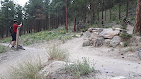
Phase 1 of PACA's new flow line. As weather and funds allow, it will keep getting extended up (and down).
Funded through a collective of amazingly generous donors, this trail is designed to all all types of riders to progress together and enjoy and entirely different experience than the Mice typically offers.

Starr Trail Solutions has engineered us an amazing little slice of heaven that will juxtapose anything you've ridden thus far in the Mice.

Access Info

Currently starts on Roller Coaster (2-track portion, after Compression Jump) a couple hundred feet in front of Tsweet Tsue.

Trail Supporters
Local Trail Association

Recent Activity on Trail

Past Week
  • 16 rides
  • 10 miles average
6 Months
  • 265 rides
  • 11 miles avg distance
All
  • 3,262 rides
  • Last: Jun 19, 2026
c1c2c3c4
January
February
March
April
May
June
July
August
September
October
November
December
update trails status or condition

Flow Coaster - Jumps Trail Reports

Status:
on Jun 1, 2026
Dry
Avg: 4.24 (15 votes)
Your vote: 0

view (0)
close
3D
Trail Conditions
  • Unknown
  • Snow Groomed
  • Snow Packed
  • Snow Covered
  • Snow Cover Partial
  • Freeze/thaw Cycle
  • Icy
  • Prevalent Mud
  • Wet
  • Variable
  • Ideal
  • Dry
  • Very Dry
Trail Flow (Ridden Direction)
Trailforks scans users ridelogs to determine the most popular direction each trail is ridden. A good flowing trail network will have most trails flowing in a single direction according to their intension.
The colour categories are based on what percentage of riders are riding a trail in its intended direction.
  • > 96%
  • > 90%
  • > 80%
  • > 70%
  • > 50%
  • < 50%
  • bi-directional trail
  • no data
Trail Last Ridden
Trailforks scans ridelogs to determine the last time a trail was ridden.
  • < 2 days
  • < 1 week
  • < 2 weeks
  • < 1 month
  • < 6 months
  • > 6 months
Trail Ridden Direction
The intended direction a trail should be ridden.
  • Downhill Only
  • Downhill Primary
  • Both Directions
  • Uphill Primary
  • Uphill Only
  • One Direction
Contribute Details
Colors indicate trail is missing specified detail.
  • Description
  • Photos
  • Description & Photos
  • Videos
Trail Popularity ?
Trailforks scans ridelogs to determine which trails are ridden the most in the last 9 months. Trails are compared with nearby trails in the same city region with a possible 25 colour shades. Think of this as a heatmap, more rides = more kinetic energy = warmer colors.
  • most popular
  • popular
  • less popular
  • not popular
ATV/ORV/OHV Filter
Max Vehicle Width
inches
US Cell Coverage
Legend
cell carrier legend

Radar Time
Activity Recordings
Trailforks uses anonymized public activity data. ?
Activity Recordings
Trailforks uses anonymized public activity data. ?
Personal Heatmap
Activity Types
all / none
Options
2
Date range month
Winter Trails
Warning A routing network for winter maps does not exist. Selecting trails using the winter trails layer has been disabled.
Missing Trails
Most Popular
Least Popular
Trails are colored based on popularity. The more popular a trail is, the more red. Less popular trails trend towards green.
Jump Magnitude Heatmap
Heatmap of where riders jump on trails. Zoom in to see individual jumps, click circles to view jump details.
BC Backroad Status

Service Road Atlas is a free to use, community-driven service for viewing and creating reports on the numerous back-country service roads around B.C. and Alberta.

map legend
Slope Aspect
Direction the slope faces
Flat N NE E SE S SW W NW
Trails Deemphasized
Trails are shown in grey.
disable
Only show trails with no bike usage.
Enable
Suggested Layers
Based on selected activity type

    Save the current map location and zoom level as your default home location whenever this page is loaded.

    Save
        Directions to flow-coaster-jumps trailhead (49.543540, -119.555690)

        Photos

        15 more »
        312 |
        Mar 27, 2019 @ 9:24pm
        Mar 27, 2019
        475 |
        Jun 24, 2018 @ 8:41pm
        Jun 24, 2018
        92 |
        Jul 17, 2025 @ 7:10am
        Jul 17, 2025
        292 |
        Oct 19, 2020 @ 9:39am
        Oct 19, 2020

        Videos

        4 more »
        Flow Coaster & Tsweet Tsue - 2022
        3:59 | 477 | May 28, 2022 , Penticton
        2 Wheels 4 Paws: Mountain Bike Trail Dog
        0:33 | 685 | Apr 28, 2019 , Penticton
        Three Blind Mice Region
        10:45 | 466 | Jul 31, 2018 , Penticton
        Kids these days
        0:09 | 317 | May 7, 2021 , Penticton

        Routes with this trail

        4.0 14 miles 2,247 ft 11
        Swagman's Backyard Ride Guide is back - this time, in two parts for the largest of the Penticton Trail...
        4.0 5 miles 202 ft 11 Shuttled
        So, you find yourself at the top of 3 Blind Mice, you may ask yourself the following questions. What's the...
        4.0 15 miles 2,706 ft 9 Loop
        A classic climb and descent to give you the most bang for your buck in the Mice. Suitable for intermediate...

        Trail Products

        4 Reviews & Comments


        We hope you've been enjoying Trailforks!

        Create a FREE account to view trail comments and much more.

        • By 1partatatimeTF Pro PACA & contributors
        • #125404 - 4,826 views

        Frequently Asked Questions About Flow Coaster - Jumps

        Where is Flow Coaster - Jumps located?
        Flow Coaster - Jumps is located in Three Blind Mice, Penticton, British Columbia, Canada. It is part of the Three Blind Mice trail network. The trailhead is located at coordinates 49.54354, -119.55569.
        How hard is Flow Coaster - Jumps?
        Flow Coaster - Jumps is rated as Black Diamond difficulty. The average grade is 6.5%.
        What is the elevation gain for Flow Coaster - Jumps?
        The trail has 43 ft of elevation descent. The elevation ranges from 1,785 ft to 1,828 ft.
        How long is Flow Coaster - Jumps?
        Flow Coaster - Jumps is 666 ft long. The trail type is singletrack.

        Hit the Trail

        Open in App

        Get this trail on your phone instantly.
        open trail in app

        Download Trail

        Save to wishlist, Garmin & download.
        save the trail

        Find Related Routes

        Find routes and users activities that include this trail.
        find routes for this trail

        You must enter a description before submitting.