more stats
2,392 ft
Distance
10 ft
Climb
-162 ft
Descent
00:01:56
Avg time
-154 ft
Altitude change
1,073 ft
Altitude min
1,227 ft
Altitude max
1,227 ft
Altitude start
1,073 ft
Altitude end
-6.4%
Grade
-33.2%
Grade max
12%
Grade min
151 ft
Distance climb
1,831 ft
Distance down
302 ft
Distance flat
00:01:56
Avg time

Flow Trail 5 Details

  • Activities
    • Mountain Bike
    • Gravel Bike
    • Adaptive Bike
    • Hike
    • Trail Running
  • Riding Area
    Soquel Demonstration State Forest
    Santa Cruz, California
  • Difficulty Rating
  • Voted Difficulty
    Blue (2 votes)
  • Local Popularity
    95 in Mountain Biking [+]
    • 45 in Trail Running
    • 85 in Hiking
  • Global Ranking
    #13533 in Mountain Biking [+]
    • #99185 in Trail Running
    • #2109 in Hiking
  • Hiking SAC Scale
    T3 Demanding Mountain Hiking
  • Trail Exposure
    Normal
  • Trail Type
    Singletrack
  • Bike Type
    AM, XC, Adaptive MTB, Gravel
  • Direction
    Downhill Only[+]
    Popular Direction Shown
    • Downhill Only for Trail Running
    • Downhill Only for Hiking
    • Downhill Only for Adaptive Biking
    • Downhill Only for Gravel Biking
  • Climb Difficulty
    Blue
  • Physical Rating
    Moderate
  • Trail Visibility
    Always easy to follow
  • Dogs Allowed
    Yes
  • eBike Allowed
  • Land Owner

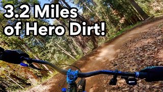
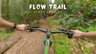
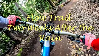
Built specifically for mountain bikes, a flow trail emphasizes speed and rhythm, featuring berms, rollers, jumps and other features that are designed in a way that uses the rider’s momentum to minimize pedaling and braking (think downhill pump track). From the young (or not so young) beginner, to the downhill pro, a flow trail delivers smiles for riders of all ages and skill level.

MBoSC has partnered with land manager California Department of Forestry and Fire Protection (CAL FIRE) to build a four mile flow trail in Soquel Demonstration State Forest (SDSF). The objectives of this project are to promote mountain biking by creating a progressive trail that can be enjoyed by riders of all ages and ability level, and to increase the diversity of riding opportunities, demonstrate innovative and sustainable trail building design and techniques, and provide a model for other land managers for similar types of projects.

Adaptive Bike Info
aMTB Blue Rating: Intermediate features and steeper terrain.
Local Trail Association
Traditionally Indigenous Territory

Recent Activity on Trail

Past Week
  • 14 rides
  • 18 miles average
6 Months
  • 310 rides
  • 19 miles avg distance
All
  • 2,892 rides
  • Last: Jun 17, 2026
c1c2c3c4
January
February
March
April
May
June
July
August
September
October
November
December
update trails status or condition

Flow Trail 5 Trail Reports

statusdatedescription
Jun 10, 2026 @ 7:03am (America/Los_Angeles)
Jun 10, 2026
reporter
May 14, 2026 @ 10:03am (America/Los_Angeles)
May 14, 2026
reporter NTD26 - Patching holes in berm.
May 12, 2026 @ 5:40pm (America/Los_Angeles)
May 12, 2026
reporter Significant tread damage.
May 12, 2026 @ 5:39pm (America/Los_Angeles)
May 12, 2026
reporter NTD26 - Repair hole in trail.
May 12, 2026 @ 5:35pm (America/Los_Angeles)
May 12, 2026
reporter NTD26 - Repair holes in berms.
more »
Status:
on Jun 10, 2026
Dry
Avg: 4.6 (46 votes)
Your vote: 0

view (21,912)
close
3D
Trail Conditions
  • Unknown
  • Snow Groomed
  • Snow Packed
  • Snow Covered
  • Snow Cover Partial
  • Freeze/thaw Cycle
  • Icy
  • Prevalent Mud
  • Wet
  • Variable
  • Ideal
  • Dry
  • Very Dry
Trail Flow (Ridden Direction)
Trailforks scans users ridelogs to determine the most popular direction each trail is ridden. A good flowing trail network will have most trails flowing in a single direction according to their intension.
The colour categories are based on what percentage of riders are riding a trail in its intended direction.
  • > 96%
  • > 90%
  • > 80%
  • > 70%
  • > 50%
  • < 50%
  • bi-directional trail
  • no data
Trail Last Ridden
Trailforks scans ridelogs to determine the last time a trail was ridden.
  • < 2 days
  • < 1 week
  • < 2 weeks
  • < 1 month
  • < 6 months
  • > 6 months
Trail Ridden Direction
The intended direction a trail should be ridden.
  • Downhill Only
  • Downhill Primary
  • Both Directions
  • Uphill Primary
  • Uphill Only
  • One Direction
Contribute Details
Colors indicate trail is missing specified detail.
  • Description
  • Photos
  • Description & Photos
  • Videos
Trail Popularity ?
Trailforks scans ridelogs to determine which trails are ridden the most in the last 9 months. Trails are compared with nearby trails in the same city region with a possible 25 colour shades. Think of this as a heatmap, more rides = more kinetic energy = warmer colors.
  • most popular
  • popular
  • less popular
  • not popular
ATV/ORV/OHV Filter
Max Vehicle Width
inches
US Cell Coverage
Legend
cell carrier legend

Radar Time
Activity Recordings
Trailforks uses anonymized public activity data. ?
Activity Recordings
Trailforks uses anonymized public activity data. ?
Personal Heatmap
Activity Types
all / none
Options
2
Date range month
Winter Trails
Warning A routing network for winter maps does not exist. Selecting trails using the winter trails layer has been disabled.
Missing Trails
Most Popular
Least Popular
Trails are colored based on popularity. The more popular a trail is, the more red. Less popular trails trend towards green.
Jump Magnitude Heatmap
Heatmap of where riders jump on trails. Zoom in to see individual jumps, click circles to view jump details.
BC Backroad Status

Service Road Atlas is a free to use, community-driven service for viewing and creating reports on the numerous back-country service roads around B.C. and Alberta.

map legend
Slope Aspect
Direction the slope faces
Flat N NE E SE S SW W NW
Trails Deemphasized
Trails are shown in grey.
disable
Only show trails with no bike usage.
Enable
Suggested Layers
Based on selected activity type

    Save the current map location and zoom level as your default home location whenever this page is loaded.

    Save
        Directions to flow-trail-5 trailhead (37.081240, -121.897610)

        Photos

        15 more »
        160 |
        Oct 29, 2018 @ 2:40am
        Oct 29, 2018
        192 |
        Oct 29, 2018 @ 2:39am
        Oct 29, 2018
        161 |
        Oct 29, 2018 @ 2:39am
        Oct 29, 2018
        22 |
        Apr 23, 2026 @ 4:21pm
        Apr 23, 2026

        Videos

        16 more »
        Last Ride Down SEQUEL MTB FLOW Trail Before...
        14:13 | 91 | May 2, 2024 , Santa Cruz
        Flow Trail / Santa Cruz, CA (Soquel Demo...
        12:31 | 148 | Apr 30, 2024 , Santa Cruz
        Flow Trail Two Weeks After the Rain
        9:30 | 265 | Jan 21, 2022 , Santa Cruz
        MTB Riding The Flow Trail | New Trail Day | in...
        21:30 | 250 | Nov 1, 2021 , Santa Cruz

        Routes with this trail

        4.2 14 miles 2,088 ft 17 Loop
        New Flow Trail in Santa Cruz
        5.0 18 miles 3,222 ft 14
        The Flow Trail is one of the best-known trails in Santa Cruz. It's 3.5 miles of fast, flowy downhill fun....
        4.3 14 miles 2,098 ft 13
        Best route for the flow trail with minimal climbing

        4 Reviews & Comments


        We hope you've been enjoying Trailforks!

        Create a FREE account to view trail comments and much more.

        Frequently Asked Questions About Flow Trail 5

        Where is Flow Trail 5 located?
        Flow Trail 5 is located in Soquel Demonstration State Forest, Santa Cruz, California, United States. It is part of the Soquel Demonstration State Forest trail network. The trailhead is located at coordinates 37.08124, -121.89761.
        How hard is Flow Trail 5?
        Flow Trail 5 is rated as Blue difficulty. The physical rating is Moderate. The average grade is 6.4%. The climb difficulty is rated Blue.
        What is the elevation gain for Flow Trail 5?
        Flow Trail 5 has 10 ft of elevation gain. The trail has 162 ft of elevation descent. The elevation ranges from 1,073 ft to 1,227 ft.
        Is Flow Trail 5 a point to point trail?
        Yes, Flow Trail 5 is a point to point trail. The direction is Downhill Only. The trail type is singletrack.

        Hit the Trail

        Open in App

        Get this trail on your phone instantly.
        open trail in app

        Download Trail

        Save to wishlist, Garmin & download.
        save the trail

        Find Related Routes

        Find routes and users activities that include this trail.
        find routes for this trail

        You must enter a description before submitting.