more stats
3.9 miles
Distance
418 ft
Climb
-951 ft
Descent
00:43:50
Avg time
-534 ft
Altitude change
1,840 ft
Altitude min
2,672 ft
Altitude max
2,374 ft
Altitude start
1,841 ft
Altitude end
-2.6%
Grade
-29.5%
Grade max
50.9%
Grade min
1 mile
Distance climb
2 miles
Distance down
1,486 ft
Distance flat
00:43:50
Avg time

Flowdown Details

  • Activities
    • Mountain Bike
    • E-Bike
    • Hike
    • Trail Running
  • Riding Area
    Mount Macpherson
    Revelstoke, British Columbia
  • Difficulty Rating
  • Local Popularity
    100 in Mountain Biking [+]
    • 100 in E-Biking
    • 80 in Trail Running
    • 75 in Hiking
  • Global Ranking
    #311 in Mountain Biking [+]
    • #1727 in E-Biking
    • #355 in Trail Running
    • #9948 in Hiking
  • Trail Type
    Singletrack
  • Bike Type
    AM, XC
  • Climb Difficulty
    Blue
  • Physical Rating
    Moderate
  • Trail Visibility
    Always easy to follow
  • Dogs Allowed
    Yes
  • eBike Allowed
  • TTFs on Trail
    Berm, Bridge, Jump, Ladder Bridge

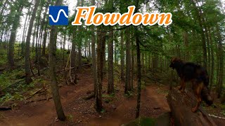
Mount Macpherson's premier flow trail makes a smooth climber, as well as a fast flowing descent trail. Remember: uphill riders have the right-of-way. This should be on your must-do list at Mount Macpherson.

Follow the signs for the blue 'ride-arounds' to avoid riding the black diamond technical trail features (TTFs).

Trail Supporters
Local Trail Association

Recent Activity on Trail

Past Week
  • 9 rides
  • 12.3 km average
6 Months
  • 71 rides
  • 16.4 km avg distance
All
  • 1,651 rides
  • Last: Jun 20, 2026
c1c2c3c4
January
February
March
April
May
June
July
August
September
October
November
December
update trails status or condition

Flowdown Trail Reports

Status:
on Jun 20, 2026
Dry
Avg: 4.27 (108 votes)
Your vote: 0

view (7,729)
close
3D
Trail Conditions
  • Unknown
  • Snow Groomed
  • Snow Packed
  • Snow Covered
  • Snow Cover Partial
  • Freeze/thaw Cycle
  • Icy
  • Prevalent Mud
  • Wet
  • Variable
  • Ideal
  • Dry
  • Very Dry
Trail Flow (Ridden Direction)
Trailforks scans users ridelogs to determine the most popular direction each trail is ridden. A good flowing trail network will have most trails flowing in a single direction according to their intension.
The colour categories are based on what percentage of riders are riding a trail in its intended direction.
  • > 96%
  • > 90%
  • > 80%
  • > 70%
  • > 50%
  • < 50%
  • bi-directional trail
  • no data
Trail Last Ridden
Trailforks scans ridelogs to determine the last time a trail was ridden.
  • < 2 days
  • < 1 week
  • < 2 weeks
  • < 1 month
  • < 6 months
  • > 6 months
Trail Ridden Direction
The intended direction a trail should be ridden.
  • Downhill Only
  • Downhill Primary
  • Both Directions
  • Uphill Primary
  • Uphill Only
  • One Direction
Contribute Details
Colors indicate trail is missing specified detail.
  • Description
  • Photos
  • Description & Photos
  • Videos
Trail Popularity ?
Trailforks scans ridelogs to determine which trails are ridden the most in the last 9 months. Trails are compared with nearby trails in the same city region with a possible 25 colour shades. Think of this as a heatmap, more rides = more kinetic energy = warmer colors.
  • most popular
  • popular
  • less popular
  • not popular
ATV/ORV/OHV Filter
Max Vehicle Width
inches
US Cell Coverage
Legend
cell carrier legend

Radar Time
Activity Recordings
Trailforks uses anonymized public activity data. ?
Activity Recordings
Trailforks uses anonymized public activity data. ?
Personal Heatmap
Activity Types
all / none
Options
2
Date range month
Winter Trails
Warning A routing network for winter maps does not exist. Selecting trails using the winter trails layer has been disabled.
Missing Trails
Most Popular
Least Popular
Trails are colored based on popularity. The more popular a trail is, the more red. Less popular trails trend towards green.
Jump Magnitude Heatmap
Heatmap of where riders jump on trails. Zoom in to see individual jumps, click circles to view jump details.
BC Backroad Status

Service Road Atlas is a free to use, community-driven service for viewing and creating reports on the numerous back-country service roads around B.C. and Alberta.

map legend
Slope Aspect
Direction the slope faces
Flat N NE E SE S SW W NW
Trails Deemphasized
Trails are shown in grey.
disable
Only show trails with no bike usage.
Enable
Suggested Layers
Based on selected activity type

    Save the current map location and zoom level as your default home location whenever this page is loaded.

    Save
        Directions to flowdown trailhead (50.967870, -118.244710)

        Photos

        4 more »
        87 |
        Apr 23, 2025 @ 5:15pm
        Apr 23, 2025
        40 |
        May 6, 2026 @ 12:09pm
        May 6, 2026
        40 |
        May 6, 2026 @ 12:08pm
        May 6, 2026
        40 |
        Apr 17, 2026 @ 3:46pm
        Apr 17, 2026

        Videos

        5 more »
        youtuber Best MTB flow trail in Revelstoke, BC - Flowdown
        10:55 | 579 | Apr 8, 2025 , Revelstoke
        youtuber Rain and Skinnies don't mix... Exhibit A
        6:18 | 1080 | Sep 28, 2019 , Revelstoke
        youtuber The ULTIMATE Action Camera Setup? // Testing a...
        14:50 | 1196 | Jun 12, 2019 , Revelstoke
        Revelstoked || New Cam Angle || Hot Rocky...
        4:11 | 811 | Sep 12, 2018 , Revelstoke

        Routes with this trail

        5.0 8 miles 1,433 ft 6 Loop
        The best part about this loop is that it gets all the hard stuff out of the way first. From the , climb up...
        7 miles 1,095 ft 5
        This ride starts at Griffith Creek and Ends at (or alt. Tantrum) trailhead for an easy ride back to...
        19 miles 3,348 ft 9
        Revelstoke! Yaaay! You're gonna have a great time there! I used trailsforks planner to make you a day of...

        14 Reviews & Comments


        We hope you've been enjoying Trailforks!

        Create a FREE account to view trail comments and much more.

        • By ankhouTF Pro & contributors
        • #5449 - 34,366 views

        Frequently Asked Questions About Flowdown

        Where is Flowdown located?
        Flowdown is located in Mount Macpherson, Revelstoke, British Columbia, Canada. It is part of the Mount Macpherson trail network. The trailhead is located at coordinates 50.96787, -118.24471.
        How hard is Flowdown?
        Flowdown is rated as Blue difficulty. The physical rating is Moderate. The average grade is 2.6%. The climb difficulty is rated Blue.
        What is the elevation gain for Flowdown?
        Flowdown has 418 ft of elevation gain. The trail has 951 ft of elevation descent. The elevation ranges from 1,840 ft to 2,672 ft.
        How long is Flowdown?
        Flowdown is 3.9 miles long. The trail type is singletrack.

        Hit the Trail

        Open in App

        Get this trail on your phone instantly.
        open trail in app

        Download Trail

        Save to wishlist, Garmin & download.
        save the trail

        Find Related Routes

        Find routes and users activities that include this trail.
        find routes for this trail

        You must enter a description before submitting.