more stats
1.1 miles
Distance
-400 ft
Descent
00:05:02
Avg time
-404 ft
Altitude change
5,395 ft
Altitude min
5,800 ft
Altitude max
5,800 ft
Altitude start
5,397 ft
Altitude end
-7.3%
Grade
-28.8%
Grade max
6.1%
Grade min
89 ft
Distance climb
1 mile
Distance down
157 ft
Distance flat
00:05:02
Avg time

Fourmiz Details

  • Activities
    • Mountain Bike
    • Winter Fat Bike
  • Riding Area
  • Ref Number
    #2
  • Difficulty Rating
  • Local Popularity
    80 in Mountain Biking
  • Global Ranking
    #32832 in Mountain Biking
  • Trail Type
    Machine Groomed
  • Bike Type
    DH, AM, XC, Fat
  • Direction
    One Direction
    Popular Direction Shown
  • Physical Rating
    Easy
  • Trail Visibility
    Always easy to follow
  • Season
    June - August
  • Family Friendly
    Yes
  • TTFs on Trail
    Berm, Bridge
  • Ride in Rain
    Yes
  • Year Opened
    2017
  • Land Owner
    Avoriaz MTB

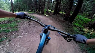
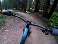
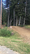
Very easy green piste with no real technical parts. 100% machine groomed with some small banked corners. Takes you from Avoriaz to the depart of the Seraussaix chairlift which then gives you access to the rest of the bikepark.

Access Info

Can be accessed from the top of the Lindarets Express chairlift (signposted), from Avoriaz and from the Col de la Joux Vert. Entrance is slightly hidden behind the Avoriaz Golf course club house.

Bike Park

Recent Activity on Trail

Past Week
  • 1 rides
  • 24.1 km average
6 Months
  • 1 rides
  • 24.1 km avg distance
All
  • 557 rides
  • Last: Jun 14, 2026
c1c2c3c4
January
February
March
April
May
June
July
August
September
October
November
December
Status:
on Aug 18, 2025
Ideal
Avg: 3.99 (6 votes)
Your vote: 0

view (4,574)
close
3D
Trail Conditions
  • Unknown
  • Snow Groomed
  • Snow Packed
  • Snow Covered
  • Snow Cover Partial
  • Freeze/thaw Cycle
  • Icy
  • Prevalent Mud
  • Wet
  • Variable
  • Ideal
  • Dry
  • Very Dry
Trail Flow (Ridden Direction)
Trailforks scans users ridelogs to determine the most popular direction each trail is ridden. A good flowing trail network will have most trails flowing in a single direction according to their intension.
The colour categories are based on what percentage of riders are riding a trail in its intended direction.
  • > 96%
  • > 90%
  • > 80%
  • > 70%
  • > 50%
  • < 50%
  • bi-directional trail
  • no data
Trail Last Ridden
Trailforks scans ridelogs to determine the last time a trail was ridden.
  • < 2 days
  • < 1 week
  • < 2 weeks
  • < 1 month
  • < 6 months
  • > 6 months
Trail Ridden Direction
The intended direction a trail should be ridden.
  • Downhill Only
  • Downhill Primary
  • Both Directions
  • Uphill Primary
  • Uphill Only
  • One Direction
Contribute Details
Colors indicate trail is missing specified detail.
  • Description
  • Photos
  • Description & Photos
  • Videos
Trail Popularity ?
Trailforks scans ridelogs to determine which trails are ridden the most in the last 9 months. Trails are compared with nearby trails in the same city region with a possible 25 colour shades. Think of this as a heatmap, more rides = more kinetic energy = warmer colors.
  • most popular
  • popular
  • less popular
  • not popular
ATV/ORV/OHV Filter
Max Vehicle Width
inches
US Cell Coverage
Legend
cell carrier legend

Radar Time
Activity Recordings
Trailforks uses anonymized public activity data. ?
Activity Recordings
Trailforks uses anonymized public activity data. ?
Personal Heatmap
Activity Types
all / none
Options
2
Date range month
Winter Trails
Warning A routing network for winter maps does not exist. Selecting trails using the winter trails layer has been disabled.
Missing Trails
Most Popular
Least Popular
Trails are colored based on popularity. The more popular a trail is, the more red. Less popular trails trend towards green.
Jump Magnitude Heatmap
Heatmap of where riders jump on trails. Zoom in to see individual jumps, click circles to view jump details.
BC Backroad Status

Service Road Atlas is a free to use, community-driven service for viewing and creating reports on the numerous back-country service roads around B.C. and Alberta.

map legend
Slope Aspect
Direction the slope faces
Flat N NE E SE S SW W NW
Trails Deemphasized
Trails are shown in grey.
disable
Only show trails with no bike usage.
Enable
Suggested Layers
Based on selected activity type

    Save the current map location and zoom level as your default home location whenever this page is loaded.

    Save
        Directions to fourmiz trailhead (46.198310, 6.764410)

        Photos

        No photos have been added for Fourmiz yet, add a photo.

        Videos

        3 more »
        DH MTB Serraussaix Fourmiz (Avoriaz/Super Morzine)
        3:06 | 448 | Jun 18, 2020 , Avoriaz
        DH MTB Serraussaix Fourmiz (Avoriaz MTB/Super...
        176 | Jun 16, 2020 , Avoriaz
        0:10 | 28 | Aug 18, 2020 , Avoriaz

        Routes with this trail

        55 miles 18,542 ft 22 Loop
        Tracé de la Pass'portes du Soleil 2023 80 km de randonnée 13 remontées mécaniques 6000 m de dénivelé...
        103 miles 27,162 ft 37
        Pass Porte du Soleill 100k Enduro loop
        67 miles 21,108 ft 22

        1 Review & Comments


        We hope you've been enjoying Trailforks!

        Create a FREE account to view trail comments and much more.

        • By AvoriazMTB & contributors
        • #97544 - 1,821 views

        Frequently Asked Questions About Fourmiz

        Where is Fourmiz located?
        Fourmiz is located in Avoriaz Bikepark, Avoriaz, France. It is part of the Avoriaz Bikepark trail network. The trailhead is located at coordinates 46.19831, 6.76441.
        How hard is Fourmiz?
        Fourmiz is rated as Green difficulty. The physical rating is Easy. The average grade is 7.3%.
        What is the elevation gain for Fourmiz?
        The trail has 122 m of elevation descent. The elevation ranges from 1,645 m to 1,768 m.
        Is Fourmiz a point to point trail?
        Yes, Fourmiz is a point to point trail. The direction is One Direction. The trail type is machine groomed.

        Hit the Trail

        Open in App

        Get this trail on your phone instantly.
        open trail in app

        Download Trail

        Save to wishlist, Garmin & download.
        save the trail

        Find Related Routes

        Find routes and users activities that include this trail.
        find routes for this trail

        You must enter a description before submitting.