more stats
1.2 miles
Distance
74 ft
Climb
-508 ft
Descent
00:13:02
Avg time
-433 ft
Altitude change
653 ft
Altitude min
1,123 ft
Altitude max
1,086 ft
Altitude start
653 ft
Altitude end
-6.7%
Grade
-40.9%
Grade max
22.2%
Grade min
1,480 ft
Distance climb
4,121 ft
Distance down
873 ft
Distance flat
00:13:02
Avg time

Freewheel Details

  • Activities
    • Mountain Bike
    • E-Bike
    • Hike
    • Trail Running
  • Riding Area
  • Difficulty Rating
  • Voted Difficulty
    Secondary Access Road/Trail (9 votes)
  • Local Popularity
    100 in Mountain Biking [+]
    • 100 in E-Biking
    • 50 in Trail Running
    • 55 in Hiking
  • Global Ranking
    #1098 in Mountain Biking [+]
    • #1940 in E-Biking
    • #91070 in Trail Running
    • #62272 in Hiking
  • Trail Type
    Singletrack
  • Bike Type
    DH, AM, XC
  • Direction
    Downhill Primary
    Popular Direction Shown
  • Physical Rating
    Moderate
  • Season
    All year
  • Dogs Allowed
    Yes
  • eBike Allowed
    Yes up to Class 1
  • TTFs on Trail
    Bridge, Drop, Jump, Rock Face
  • Ride in Rain
    Yes
  • Year Opened
    2013
  • Land Owner
    Hutt City Council

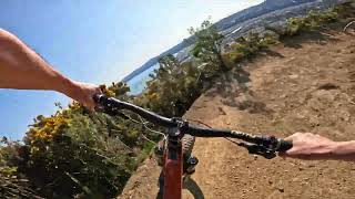
Freewheel is a fast flowing single track taking you from the Towai Trig to the Wainuiomata Hill Rd summit.

Freewheel traverses the western side of the hill (the Hutt side). It is fast flowing with an array of jumps, drops, switchbacks, shoots, banked turns, and lots of lovely gorse to catch you if come off and fall down the hill.

Access Info

Access is from the ECNZ 4x4 access road. You can either ride up the access road, ride Labyrinth until the Spoonhill/Towai Traverse junction and join the access road or ride to the end of Towai Traverse. At the end of Towai Traverse turn left (south) and follow the access road until you see the entrance to Freewheel on the right (across a little wooden bridge).

Local Trail Association

Recent Activity on Trail

Past Week
  • 3 rides
  • 6 miles average
6 Months
  • 135 rides
  • 11 miles avg distance
All
  • 837 rides
  • Last: Jun 15, 2026
c1c2c3c4
January
February
March
April
May
June
July
August
September
October
November
December
update trails status or condition

Freewheel Trail Reports

Status:
on Jan 23, 2026
Ideal
Avg: 4 (39 votes)
Your vote: 0

view (10,617)
close
3D
Trail Conditions
  • Unknown
  • Snow Groomed
  • Snow Packed
  • Snow Covered
  • Snow Cover Partial
  • Freeze/thaw Cycle
  • Icy
  • Prevalent Mud
  • Wet
  • Variable
  • Ideal
  • Dry
  • Very Dry
Trail Flow (Ridden Direction)
Trailforks scans users ridelogs to determine the most popular direction each trail is ridden. A good flowing trail network will have most trails flowing in a single direction according to their intension.
The colour categories are based on what percentage of riders are riding a trail in its intended direction.
  • > 96%
  • > 90%
  • > 80%
  • > 70%
  • > 50%
  • < 50%
  • bi-directional trail
  • no data
Trail Last Ridden
Trailforks scans ridelogs to determine the last time a trail was ridden.
  • < 2 days
  • < 1 week
  • < 2 weeks
  • < 1 month
  • < 6 months
  • > 6 months
Trail Ridden Direction
The intended direction a trail should be ridden.
  • Downhill Only
  • Downhill Primary
  • Both Directions
  • Uphill Primary
  • Uphill Only
  • One Direction
Contribute Details
Colors indicate trail is missing specified detail.
  • Description
  • Photos
  • Description & Photos
  • Videos
Trail Popularity ?
Trailforks scans ridelogs to determine which trails are ridden the most in the last 9 months. Trails are compared with nearby trails in the same city region with a possible 25 colour shades. Think of this as a heatmap, more rides = more kinetic energy = warmer colors.
  • most popular
  • popular
  • less popular
  • not popular
ATV/ORV/OHV Filter
Max Vehicle Width
inches
US Cell Coverage
Legend
cell carrier legend

Radar Time
Activity Recordings
Trailforks uses anonymized public activity data. ?
Activity Recordings
Trailforks uses anonymized public activity data. ?
Personal Heatmap
Activity Types
all / none
Options
2
Date range month
Winter Trails
Warning A routing network for winter maps does not exist. Selecting trails using the winter trails layer has been disabled.
Missing Trails
Most Popular
Least Popular
Trails are colored based on popularity. The more popular a trail is, the more red. Less popular trails trend towards green.
Jump Magnitude Heatmap
Heatmap of where riders jump on trails. Zoom in to see individual jumps, click circles to view jump details.
BC Backroad Status

Service Road Atlas is a free to use, community-driven service for viewing and creating reports on the numerous back-country service roads around B.C. and Alberta.

map legend
Slope Aspect
Direction the slope faces
Flat N NE E SE S SW W NW
Trails Deemphasized
Trails are shown in grey.
disable
Only show trails with no bike usage.
Enable
Suggested Layers
Based on selected activity type

    Save the current map location and zoom level as your default home location whenever this page is loaded.

    Save
        Directions to freewheel trailhead (-41.233880, 174.929520)

        Photos

        25 more »
        55 |
        Jan 30, 2023 @ 10:46pm
        Jan 30, 2023
        66 |
        Jan 30, 2023 @ 10:46pm
        Jan 30, 2023
        165 |
        Aug 12, 2020 @ 7:13pm
        Aug 12, 2020
        158 |
        Feb 8, 2020 @ 1:50pm
        Feb 8, 2020

        Videos

        11 more »
        youtuber Freewheel !!REBUILT!! @ Wainuiomata Trail Park
        6:07 | 240 | Sep 30, 2024 , Lower Hutt
        youtuber Freewheel @ Wainuiomata Trail Park
        7:25 | 421 | Jun 14, 2022 , Lower Hutt
        youtuber FAST, TECHY & SCENIC - Freewheel Mountain...
        6:26 | 654 | Mar 19, 2021 , Lower Hutt
        youtuber Freewheel : Wainui Trail Project
        7:06 | 828 | Jul 7, 2018 , Lower Hutt

        Routes with this trail

        2 miles 98 ft 4 Point to Point
        From the trig at the top of Freewheel, all the way down to Gracefield Road. around 300 vertical metres....
        3 miles 663 ft 6 Loop
        A intermediate loop from the mapboard at the Pukeatau Bridge. Climb Labyrinth, ride the full length of ,...
        13 miles 2,803 ft 22 Loop
        Up from Te Whiti park, couple of freewheel loops of upper bike park then down snails up jungles and return...

        4 Reviews & Comments


        We hope you've been enjoying Trailforks!

        Create a FREE account to view trail comments and much more.

        • By nikholden & contributors
        • #17292 - 12,875 views

        Frequently Asked Questions About Freewheel

        Where is Freewheel located?
        Freewheel is located in Wainuiomata Trail Park (WTP), Lower Hutt, New Zealand. It is part of the Wainuiomata Trail Park (WTP) trail network. The trailhead is located at coordinates -41.23388, 174.92952.
        How hard is Freewheel?
        Freewheel is rated as Blue difficulty. The physical rating is Moderate. The average grade is 6.7%.
        What is the elevation gain for Freewheel?
        Freewheel has 74 ft of elevation gain. The trail has 508 ft of elevation descent. The elevation ranges from 653 ft to 1,123 ft.
        Is Freewheel a point to point trail?
        Freewheel is not a point to point trail. The direction is Downhill Primary. The trail type is singletrack.

        Hit the Trail

        Open in App

        Get this trail on your phone instantly.
        open trail in app

        Download Trail

        Save to wishlist, Garmin & download.
        save the trail

        Find Related Routes

        Find routes and users activities that include this trail.
        find routes for this trail

        You must enter a description before submitting.