more stats
4.4 miles
Distance
11 ft
Climb
-1,932 ft
Descent
00:15:43
Avg time
-1,922 ft
Altitude change
9,015 ft
Altitude min
10,937 ft
Altitude max
10,937 ft
Altitude start
9,016 ft
Altitude end
-8.2%
Grade
-45.7%
Grade max
7.4%
Grade min
505 ft
Distance climb
4 miles
Distance down
1,289 ft
Distance flat
00:15:43
Avg time

French Press Details

  • Activities
    • Mountain Bike
  • Riding Area
    Snowmass Bike Park
    Snowmass Village, Colorado
  • Difficulty Rating
  • Voted Difficulty
    Blue (1 vote)
  • Local Popularity
    80 in Mountain Biking
  • Global Ranking
    #37508 in Mountain Biking
  • Trail Type
    Singletrack
  • Direction
    Downhill Only
    Popular Direction Shown
  • Dogs Allowed
    Yes
  • eBike Allowed

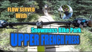
The longest flow trail In Snowmass Bike park. Starts all the way up from the Elk Camp chair and descends through high speed berms and rollers. Entire trail can be rolled. Immediately became one of the most popular trails in the park.

Trail Supporters

  • USFS
    Land Manager

Bike Park

Traditionally Indigenous Territory

Recent Activity on Trail

Past Week
  • 0 rides
  •  
6 Months
  • 1 rides
  • 5 miles avg distance
All
  • 336 rides
  • Last: Jun 3, 2026
c1c2c3c4
January
February
March
April
May
June
July
August
September
October
November
December
update trails status or condition

French Press Trail Reports

statusdatedescription
Sep 30, 2023 @ 11:05am
Sep 30, 2023
Jul 23, 2023 @ 3:46am
Jul 23, 2023
French Press to Valkyrie was phenomenal today. Very few riders. Trail in great shape. If I were to note anything it wasn't one of those perfectly...
Sep 23, 2022 @ 9:10am
Sep 23, 2022
Sep 17, 2022 @ 10:35am
Sep 17, 2022
Jul 29, 2022 @ 10:23am
Jul 29, 2022
more »
Status:
on Sep 30, 2023
Ideal
Avg: 4.26 (9 votes)
Your vote: 0

view (2,705)
close
3D
Trail Conditions
  • Unknown
  • Snow Groomed
  • Snow Packed
  • Snow Covered
  • Snow Cover Partial
  • Freeze/thaw Cycle
  • Icy
  • Prevalent Mud
  • Wet
  • Variable
  • Ideal
  • Dry
  • Very Dry
Trail Flow (Ridden Direction)
Trailforks scans users ridelogs to determine the most popular direction each trail is ridden. A good flowing trail network will have most trails flowing in a single direction according to their intension.
The colour categories are based on what percentage of riders are riding a trail in its intended direction.
  • > 96%
  • > 90%
  • > 80%
  • > 70%
  • > 50%
  • < 50%
  • bi-directional trail
  • no data
Trail Last Ridden
Trailforks scans ridelogs to determine the last time a trail was ridden.
  • < 2 days
  • < 1 week
  • < 2 weeks
  • < 1 month
  • < 6 months
  • > 6 months
Trail Ridden Direction
The intended direction a trail should be ridden.
  • Downhill Only
  • Downhill Primary
  • Both Directions
  • Uphill Primary
  • Uphill Only
  • One Direction
Contribute Details
Colors indicate trail is missing specified detail.
  • Description
  • Photos
  • Description & Photos
  • Videos
Trail Popularity ?
Trailforks scans ridelogs to determine which trails are ridden the most in the last 9 months. Trails are compared with nearby trails in the same city region with a possible 25 colour shades. Think of this as a heatmap, more rides = more kinetic energy = warmer colors.
  • most popular
  • popular
  • less popular
  • not popular
ATV/ORV/OHV Filter
Max Vehicle Width
inches
US Cell Coverage
Legend
cell carrier legend

Radar Time
Activity Recordings
Trailforks uses anonymized public activity data. ?
Activity Recordings
Trailforks uses anonymized public activity data. ?
Personal Heatmap
Activity Types
all / none
Options
2
Date range month
Winter Trails
Warning A routing network for winter maps does not exist. Selecting trails using the winter trails layer has been disabled.
Missing Trails
Most Popular
Least Popular
Trails are colored based on popularity. The more popular a trail is, the more red. Less popular trails trend towards green.
Jump Magnitude Heatmap
Heatmap of where riders jump on trails. Zoom in to see individual jumps, click circles to view jump details.
BC Backroad Status

Service Road Atlas is a free to use, community-driven service for viewing and creating reports on the numerous back-country service roads around B.C. and Alberta.

map legend
Slope Aspect
Direction the slope faces
Flat N NE E SE S SW W NW
Trails Deemphasized
Trails are shown in grey.
disable
Only show trails with no bike usage.
Enable
Suggested Layers
Based on selected activity type

    Save the current map location and zoom level as your default home location whenever this page is loaded.

    Save
        Directions to french-press trailhead (39.171290, -106.930960)

        Photos

        13 more »
        54 |
        Aug 27, 2024 @ 1:41pm
        Aug 27, 2024
        197 |
        Jul 1, 2021 @ 2:36pm
        Jul 1, 2021
        175 |
        Jul 1, 2021 @ 2:36pm
        Jul 1, 2021
        431 |
        Jul 1, 2021 @ 2:36pm
        Jul 1, 2021

        Videos

        3 more »
        youtuber Fast Flow Served // Downhill Mountain Biking...
        15:35 | 786 | Sep 24, 2018 , Snowmass Village
        Snowmass Bike Park - French Press 28 Sep 2024
        45 | Feb 24, 2025 , Snowmass Village
        Hypnotizing Speeds and Golden Leaves - French...
        6:46 | 419 | Nov 18, 2020 , Snowmass Village

        1 Review & Comments


        We hope you've been enjoying Trailforks!

        Create a FREE account to view trail comments and much more.

        • By toddTF Pro Trailforks & contributors
        • #139248 - 6,085 views

        Frequently Asked Questions About French Press

        Where is French Press located?
        French Press is located in Snowmass Bike Park, Snowmass Village, Colorado, United States. It is part of the Snowmass Bike Park trail network. The trailhead is located at coordinates 39.17129, -106.93096.
        How hard is French Press?
        French Press is rated as Blue difficulty. The average grade is 8.2%.
        What is the elevation gain for French Press?
        French Press has 11 ft of elevation gain. The trail has 1,932 ft of elevation descent. The elevation ranges from 9,015 ft to 10,937 ft.
        Is French Press a point to point trail?
        Yes, French Press is a point to point trail. The direction is Downhill Only. The trail type is singletrack.

        Hit the Trail

        Open in App

        Get this trail on your phone instantly.
        open trail in app

        Download Trail

        Save to wishlist, Garmin & download.
        save the trail

        Find Related Routes

        Find routes and users activities that include this trail.
        find routes for this trail

        You must enter a description before submitting.