more stats
3.3 miles
Distance
227 ft
Climb
-1,805 ft
Descent
00:17:54
Avg time
-1,578 ft
Altitude change
1,404 ft
Altitude min
3,003 ft
Altitude max
2,982 ft
Altitude start
1,404 ft
Altitude end
-9.1%
Grade
-54.6%
Grade max
32%
Grade min
2,690 ft
Distance climb
2 miles
Distance down
1,575 ft
Distance flat
00:17:54
Avg time

Freund Canyon Details

  • Activities
    • Mountain Bike
    • E-Bike
    • Winter Fat Bike
    • Hike
    • Trail Running
  • Riding Area
    Leavenworth Hill
    Leavenworth, Washington
  • Difficulty Rating
  • Voted Difficulty
    Blue (4 votes)
  • Local Popularity
    95 in Mountain Biking [+]
    • 80 in E-Biking
    • 90 in Trail Running
    • 80 in Hiking
  • Global Ranking
    #26327 in Mountain Biking [+]
    • #4939 in E-Biking
    • #1039 in Trail Running
    • #4202 in Hiking
  • Trail Type
    Singletrack
  • Bike Type
    DH, AM, XC, Fat, CX
  • Direction
    Downhill Primary
    Popular Direction Shown
  • Climb Difficulty
    Blue
  • Physical Rating
    Moderate
  • Season
    Spring - Fall
  • Family Friendly
    Yes
  • Dogs Allowed
    Yes
  • eBike Allowed
  • TTFs on Trail
    Berm, Jump, Wallride

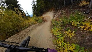
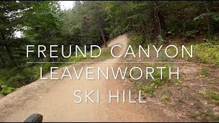
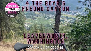
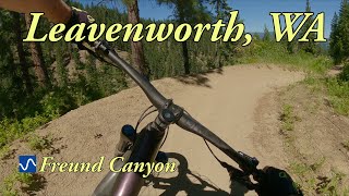
Freund descending trail is certainly one of the more unique trails in Washington. With what one might call a "descending traverse", most of Freund trails left turns feature trail that rides up the wall of the high side of the hill. On right turns, medium sized berms were constructed, creating a continuous snake-like descent that alternates between wall ride and berm.

Between each set of wall ride to berms is a waterbar jump. This trail is fun, go ride it

* note that its not uncommon to see runners on this trail, so give into the urge to hoot and holler and let everyone know you are coming down the trail. Share the trail!

Local Trail Association
Traditionally Indigenous Territory

Recent Activity on Trail

Past Week
  • 7 rides
  • 12 miles average
6 Months
  • 52 rides
  • 13 miles avg distance
All
  • 570 rides
  • Last: Jun 19, 2026
c1c2c3c4
January
February
March
April
May
June
July
August
September
October
November
December
update trails status or condition

Freund Canyon Trail Reports

statusdatedescription
Jun 6, 2026 @ 9:25am (America/Vancouver)
Jun 6, 2026
Mar 7, 2026 @ 12:10pm (America/Los_Angeles)
Mar 7, 2026
Large tree down across trail, blocking trail
Aug 12, 2025 @ 8:24am
Aug 12, 2025
Jun 27, 2025 @ 9:01am
Jun 27, 2025
Getting a bit sandy and the braking bumps are bad, but running good!
May 16, 2025 @ 8:58pm
May 16, 2025
Fast and flowy. Quite a lot of brake bumps that help the rider understand where everyone else lays on the brakes. I actually found myself braking...
more »
Status:
on Jun 6, 2026
Ideal
Avg: 4.25 (22 votes)
Your vote: 0

view (1,874)
close
3D
Trail Conditions
  • Unknown
  • Snow Groomed
  • Snow Packed
  • Snow Covered
  • Snow Cover Partial
  • Freeze/thaw Cycle
  • Icy
  • Prevalent Mud
  • Wet
  • Variable
  • Ideal
  • Dry
  • Very Dry
Trail Flow (Ridden Direction)
Trailforks scans users ridelogs to determine the most popular direction each trail is ridden. A good flowing trail network will have most trails flowing in a single direction according to their intension.
The colour categories are based on what percentage of riders are riding a trail in its intended direction.
  • > 96%
  • > 90%
  • > 80%
  • > 70%
  • > 50%
  • < 50%
  • bi-directional trail
  • no data
Trail Last Ridden
Trailforks scans ridelogs to determine the last time a trail was ridden.
  • < 2 days
  • < 1 week
  • < 2 weeks
  • < 1 month
  • < 6 months
  • > 6 months
Trail Ridden Direction
The intended direction a trail should be ridden.
  • Downhill Only
  • Downhill Primary
  • Both Directions
  • Uphill Primary
  • Uphill Only
  • One Direction
Contribute Details
Colors indicate trail is missing specified detail.
  • Description
  • Photos
  • Description & Photos
  • Videos
Trail Popularity ?
Trailforks scans ridelogs to determine which trails are ridden the most in the last 9 months. Trails are compared with nearby trails in the same city region with a possible 25 colour shades. Think of this as a heatmap, more rides = more kinetic energy = warmer colors.
  • most popular
  • popular
  • less popular
  • not popular
ATV/ORV/OHV Filter
Max Vehicle Width
inches
US Cell Coverage
Legend
cell carrier legend

Radar Time
Activity Recordings
Trailforks uses anonymized public activity data. ?
Activity Recordings
Trailforks uses anonymized public activity data. ?
Personal Heatmap
Activity Types
all / none
Options
2
Date range month
Winter Trails
Warning A routing network for winter maps does not exist. Selecting trails using the winter trails layer has been disabled.
Missing Trails
Most Popular
Least Popular
Trails are colored based on popularity. The more popular a trail is, the more red. Less popular trails trend towards green.
Jump Magnitude Heatmap
Heatmap of where riders jump on trails. Zoom in to see individual jumps, click circles to view jump details.
BC Backroad Status

Service Road Atlas is a free to use, community-driven service for viewing and creating reports on the numerous back-country service roads around B.C. and Alberta.

map legend
Slope Aspect
Direction the slope faces
Flat N NE E SE S SW W NW
Trails Deemphasized
Trails are shown in grey.
disable
Only show trails with no bike usage.
Enable
Suggested Layers
Based on selected activity type

    Save the current map location and zoom level as your default home location whenever this page is loaded.

    Save
        Directions to freund-canyon trailhead (47.625920, -120.692460)

        Photos

        57 more »
        72 |
        Aug 26, 2024 @ 11:36am
        Aug 26, 2024
        165 |
        Oct 11, 2023 @ 5:59pm
        Oct 11, 2023
        123 |
        Oct 11, 2023 @ 5:58pm
        Oct 11, 2023
        47 |
        May 30, 2023 @ 5:34pm
        May 30, 2023

        Videos

        10 more »
        youtuber This Trail has HILLSIDE BERMS!
        9:08 | 127 | Nov 10, 2025 , Leavenworth
        Freund Canyon - Leavenworth Ski Hill -...
        11:35 | 600 | Oct 20, 2023 , Leavenworth
        More Leavenworth Shred! 4 The Boys into Freund...
        12:41 | 275 | Jul 31, 2023 , Leavenworth
        youtuber Freund Canyon
        9:09 | 722 | Aug 6, 2022 , Leavenworth

        Routes with this trail

        5.0 8 miles 1,990 ft 3 Loop
        A Tidy Loop Starting and Ending at the
        5.0 13 miles 3,280 ft 20 Loop
        Fun loop to get 2 nice climbs and descents.
        23 miles 5,910 ft 13 Loop
        This is a great loop that can be ridden from town and incorporates all 3 Ski Hill flow trails without...

        8 Reviews & Comments


        We hope you've been enjoying Trailforks!

        Create a FREE account to view trail comments and much more.

        Frequently Asked Questions About Freund Canyon

        Where is Freund Canyon located?
        Freund Canyon is located in Leavenworth Hill, Leavenworth, Washington, United States. It is part of the Leavenworth Hill trail network. The trailhead is located at coordinates 47.62592, -120.69246.
        How hard is Freund Canyon?
        Freund Canyon is rated as Blue difficulty. The physical rating is Moderate. The average grade is 9.1%. The climb difficulty is rated Blue.
        What is the elevation gain for Freund Canyon?
        Freund Canyon has 227 ft of elevation gain. The trail has 1,805 ft of elevation descent. The elevation ranges from 1,404 ft to 3,003 ft.
        Is Freund Canyon a point to point trail?
        Freund Canyon is not a point to point trail. The direction is Downhill Primary. The trail type is singletrack.

        Hit the Trail

        Open in App

        Get this trail on your phone instantly.
        open trail in app

        Download Trail

        Save to wishlist, Garmin & download.
        save the trail

        Find Related Routes

        Find routes and users activities that include this trail.
        find routes for this trail

        You must enter a description before submitting.