more stats
5.7 miles
Distance
60 ft
Climb
-2,251 ft
Descent
00:52:09
Avg time
-2,191 ft
Altitude change
4,945 ft
Altitude min
7,136 ft
Altitude max
7,136 ft
Altitude start
4,944 ft
Altitude end
-7.3%
Grade
-40.8%
Grade max
8.1%
Grade min
2,549 ft
Distance climb
5 miles
Distance down
1,480 ft
Distance flat
00:52:09
Avg time

Fuji Mountain Details

  • Activities
    • Mountain Bike
    • Hike
    • Trail Running
  • Riding Area
  • Difficulty Rating
  • Local Popularity
    65 in Mountain Biking [+]
    • 95 in Trail Running
    • 75 in Hiking
  • Global Ranking
    #83983 in Mountain Biking [+]
    • #32641 in Trail Running
    • #270753 in Hiking
  • Trail Type
    Singletrack
  • Bike Type
    AM, XC, Fat
  • Direction
    Both Directions
  • Climb Difficulty
    Black Diamond
  • Physical Rating
    Extreme
  • Dogs Allowed
    Yes
  • eBike Allowed
  • Land Owner

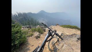
Steep, technical, and high elevation two-way trail up to the top of Fuji Mountain. Many fall-line sections and rock gardens, both of which increase in frequency towards the top of the mountain. The climb up inevitably turns into a hike-a-bike, but the views at the top and the descent is worth it.

Access Info

Access at the bottom from USFS Rd 5897. Crosses the South Waldo Lake trail at about its midpoint up the climb, and a short spur near the top leads to USFS Rd 5883, which in turn will take you to Bunchgrass trail.

Trail Supporters
Local Trail Association

Recent Activity on Trail

Past Week
  • 1 rides
  • 15 miles average
6 Months
  • 1 rides
  • 15 miles avg distance
All
  • 47 rides
  • Last: Jun 14, 2026
c1c2c3c4
January
February
March
April
May
June
July
August
September
October
November
December
update trails status or condition

Fuji Mountain Trail Reports

statusdatedescription
Jun 14, 2026 @ 5:23pm (America/Los_Angeles)
Jun 14, 2026
still too many trees down. still beautiful.
Apr 28, 2026 @ 10:28pm (America/Los_Angeles)
Apr 28, 2026
Too many trees down. It’s not worth the hassle right now
Dec 8, 2025 @ 11:35pm (America/Los_Angeles)
Dec 8, 2025
Wet and juicy. Bunch of trees down but nothing I couldn’t throw my heavy bike over.
Oct 5, 2025 @ 6:23pm (America/Los_Angeles)
Oct 5, 2025
reporter scrappy in a few spots but overall extremely fun. dank loam and scenery overload.
Sep 14, 2025 @ 6:49pm (America/Los_Angeles)
Sep 14, 2025
Large tree down across trail at 43.64485638,-12209312880, can ride over or around
more »
Status:
on Jun 14, 2026
Ideal
Avg: 4.29 (4 votes)
Your vote: 0

view (271)
close
3D
Trail Conditions
  • Unknown
  • Snow Groomed
  • Snow Packed
  • Snow Covered
  • Snow Cover Partial
  • Freeze/thaw Cycle
  • Icy
  • Prevalent Mud
  • Wet
  • Variable
  • Ideal
  • Dry
  • Very Dry
Trail Flow (Ridden Direction)
Trailforks scans users ridelogs to determine the most popular direction each trail is ridden. A good flowing trail network will have most trails flowing in a single direction according to their intension.
The colour categories are based on what percentage of riders are riding a trail in its intended direction.
  • > 96%
  • > 90%
  • > 80%
  • > 70%
  • > 50%
  • < 50%
  • bi-directional trail
  • no data
Trail Last Ridden
Trailforks scans ridelogs to determine the last time a trail was ridden.
  • < 2 days
  • < 1 week
  • < 2 weeks
  • < 1 month
  • < 6 months
  • > 6 months
Trail Ridden Direction
The intended direction a trail should be ridden.
  • Downhill Only
  • Downhill Primary
  • Both Directions
  • Uphill Primary
  • Uphill Only
  • One Direction
Contribute Details
Colors indicate trail is missing specified detail.
  • Description
  • Photos
  • Description & Photos
  • Videos
Trail Popularity ?
Trailforks scans ridelogs to determine which trails are ridden the most in the last 9 months. Trails are compared with nearby trails in the same city region with a possible 25 colour shades. Think of this as a heatmap, more rides = more kinetic energy = warmer colors.
  • most popular
  • popular
  • less popular
  • not popular
ATV/ORV/OHV Filter
Max Vehicle Width
inches
US Cell Coverage
Legend
cell carrier legend

Radar Time
Activity Recordings
Trailforks uses anonymized public activity data. ?
Activity Recordings
Trailforks uses anonymized public activity data. ?
Personal Heatmap
Activity Types
all / none
Options
2
Date range month
Winter Trails
Warning A routing network for winter maps does not exist. Selecting trails using the winter trails layer has been disabled.
Missing Trails
Most Popular
Least Popular
Trails are colored based on popularity. The more popular a trail is, the more red. Less popular trails trend towards green.
Jump Magnitude Heatmap
Heatmap of where riders jump on trails. Zoom in to see individual jumps, click circles to view jump details.
BC Backroad Status

Service Road Atlas is a free to use, community-driven service for viewing and creating reports on the numerous back-country service roads around B.C. and Alberta.

map legend
Slope Aspect
Direction the slope faces
Flat N NE E SE S SW W NW
Trails Deemphasized
Trails are shown in grey.
disable
Only show trails with no bike usage.
Enable
Suggested Layers
Based on selected activity type

    Save the current map location and zoom level as your default home location whenever this page is loaded.

    Save
        Directions to fuji-mountain trailhead (43.659130, -122.103330)

        Photos

        6 more »
        91 |
        Jun 24, 2024 @ 7:51am
        Jun 24, 2024
        101 |
        Jun 24, 2024 @ 7:51am
        Jun 24, 2024
        100 |
        Jun 24, 2024 @ 7:51am
        Jun 24, 2024
        101 |
        Jun 24, 2024 @ 7:51am
        Jun 24, 2024

        Videos

        1 more »
        Fuji Mountain  |  Oregon
        12:37 | 226 | Jul 22, 2024 , Oakridge

        Trail Products

        4 Reviews & Comments


        We hope you've been enjoying Trailforks!

        Create a FREE account to view trail comments and much more.

        Frequently Asked Questions About Fuji Mountain

        Where is Fuji Mountain located?
        Fuji Mountain is located in Waldo Lake Area and Wilderness, Oakridge, Oregon, United States. It is part of the Waldo Lake Area and Wilderness trail network. The trailhead is located at coordinates 43.65913, -122.10333.
        How hard is Fuji Mountain?
        Fuji Mountain is rated as Black Diamond difficulty. The physical rating is Extreme. The average grade is 7.3%. The climb difficulty is rated Black Diamond.
        What is the elevation gain for Fuji Mountain?
        Fuji Mountain has 60 ft of elevation gain. The trail has 2,251 ft of elevation descent. The elevation ranges from 4,945 ft to 7,136 ft.
        Is Fuji Mountain a point to point trail?
        Fuji Mountain is not a point to point trail. The direction is Both Directions. The trail type is singletrack.

        Hit the Trail

        Open in App

        Get this trail on your phone instantly.
        open trail in app

        Download Trail

        Save to wishlist, Garmin & download.
        save the trail

        Find Related Routes

        Find routes and users activities that include this trail.
        find routes for this trail

        You must enter a description before submitting.